Rochester metropolitan area, Minnesota
Rochester, Minnesota MSA | |
|---|---|
 | |
| Country | |
| States |
|
| Principal cities | Rochester |
| Area | |
| • Metro | 2,507 sq mi (6,490 km2) |
| Population (2018) | |
| • MSA | 221,587 |
| • CSA | 259,813 |
| Time zone | UTC−6 (CST) |
| • Summer (DST) | UTC−5 (CDT) |
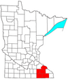
The United States Census Bureau defines the Rochester, Minnesota Metropolitan Statistical Area (MSA) as an area consisting of five counties in southeast Minnesota, anchored by the city of Rochester. As of 2018, the US Census Bureau estimates that the Rochester metropolitan statistical area has a population of 221,587. The Rochester–Austin combined statistical area has a population of 259,813 as of 2018.
Counties[]
- Dodge
- Fillmore
- Mower (Grand Meadow, Racine)
- Olmsted
- Wabasha
Communities[]
Cities[]
- Places with more than 100,000 inhabitants: Rochester.
- Places with 2,500 to 10,000 inhabitants: Byron, Chatfield, Dodge Center, Kasson, Lake City (partial), Pine Island (partial), Plainview, Stewartville, Wabasha.
- Places with 1,000 to 2,500 inhabitants: Blooming Prairie (partial), Eyota, Grand Meadow, Harmony, Hayfield, Mantorville, Oronoco, Preston, Rushford, Spring Valley.
- Places with less than 1,000 inhabitants: Bellechester (partial), Canton, Claremont, Dover, Elgin, Fountain, Hammond, Kellogg, Lanesboro, Mabel, Mazeppa, Millville, Minneiska (partial) Ostrander, Peterson, Racine, Rushford Village, West Concord, Whalan, Wykoff, Zumbro Falls.
- Unincorporated places: Douglas, Simpson, South Troy, Potsdam, Berne, Salem Corners, Chester, Pleasant Grove, Genoa, Post Town, Danesville
Townships[]
- Townships with more than 2,500 inhabitants: Cascade, Marion, Plainview, Rochester.
- Townships with 1,000 to 2,500 inhabitants:Grand Meadow, Greenfield, Haverhill, High Forest, Kalmar, Mantorville, New Haven, Oronoco, Salem.
- Townships with 500 to 1,000 inhabitants: Canisteo, Concord, Elgin, Gillford, Mazeppa, Milton, Orion, Pleasant Grove, Rock Dell, Vernon, Viola, Wasioja, Zumbro.
- Townships with less than 500 inhabitants: Ashland, Chester, Claremont, Dover, Ellington, Elmira, Eyota, Glasgow, Hayfield, Highland, Hyde Park, Lake, Minneiska, Mount Pleasant, Oakwood, Pepin, Quincy, Racine, Ripley, Watopa, West Albany, Westfield.
Demographics[]
As of the census[1] of 2000, there were 163,618 people, 62,504 households, and 43,046 families residing within the MSA. The racial makeup of the MSA was 92.01% White, 2.09% African American, 0.25% Native American, 3.34% Asian, 0.03% Pacific Islander, 0.99% from other races, and 1.29% from two or more races. Hispanic or Latino of any race were 2.35% of the population.
The median income for a household in the MSA was $46,957, and the median income for a family was $55,450. Males had a median income of $35,815 versus $26,738 for females. The per capita income for the MSA was $21,287.
Transportation[]
Highways[]
Interstate Highways[]
 Interstate 90
US Highways[]
 U.S. Highway 14
 U.S. Highway 52
 U.S. Highway 61
 U.S. Highway 63
 U.S. Highway 218 (briefly runs through Dodge County)
Minnesota State Highways[]
 Minnesota State Highway 16
 Minnesota State Highway 30
 Minnesota State Highway 42
 Minnesota State Highway 43
 Minnesota State Highway 44
 Minnesota State Highway 56
 Minnesota State Highway 57
 Minnesota State Highway 60
 Minnesota State Highway 74
 Minnesota State Highway 80
 Minnesota State Highway 139
 Minnesota State Highway 247
 Minnesota State Highway 250
Public Airports[]
Commercial[]
General Aviation[]
Government and Politics[]
Federal Representation[]
Most of the Rochester metropolitan area falls in Minnesota's 1st Congressional District, represented by Republican Jim Hagedorn. Wabasha County falls in , represented by Democrat Angie Craig. Despite Wabasha County falling in a district represented by a Democrat, the county traditionally votes strongly Republican.
State Representation[]
The following list shows the Rochester metropolitan area's representation in the Minnesota Senate:
| Name | District | First Elected | Party | County Represented within MSA |
|---|---|---|---|---|
| Mike Goggin | District 21 | 2016 | Republican | Wabasha |
| John Jasinski | District 24 | 2016 | Republican | Dodge |
| Dave Senjem | District 25 | 2002 | Republican | Olmsted, Dodge |
| Carla Nelson | District 26 | 2010 | Republican | Olmsted |
| Gene Dornink | District 27 | 2020 | Republican | Mower |
| Jeremy Miller | District 28 | 2010 | Republican | Fillmore |
See also[]
- Minnesota census statistical areas
References[]
- ^ "U.S. Census website". United States Census Bureau. Retrieved 2008-01-31.
Rochester, Minnesota Metropolitan Area | ||
|---|---|---|
| Core city |
|  |
| Incorporated Places | ||
| Counties |
| |
‡ indicates that it is partially in the metropolitan area. † indicates a county seat. | ||
Saint Paul (capital) | |||||
| Topics |
| ||||
| Society | |||||
| Regions | |||||
| Largest cities pop. over 25,000 |
| ||||
| Counties |
| ||||
| Attractions |
| ||||

Great Lakes megalopolis as defined by the RPA | ||
|---|---|---|
Includes all metropolitan areas have a population of 150,000 or greater according to the most recent national census. | ||
| Great Lakes region cities |
|  |
| Surrounding cities |
| |
| Cities of states south of region | ||
| Other metro-regions |
| |
- Rochester metropolitan area, Minnesota
- Olmsted County, Minnesota
- Geography of Dodge County, Minnesota
- Wabasha County, Minnesota
- Mower County, Minnesota
- Fillmore County, Minnesota
- Dodge County, Minnesota