Rosemount, Minnesota
Rosemount | |
|---|---|
City | |
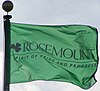 Flag | |
| Motto(s): "Spirit of Pride and Progress" | |
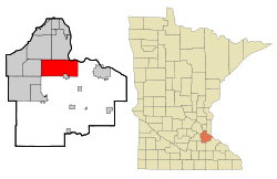 Location of the city of Rosemount within Dakota County, Minnesota | |
| Coordinates: 44°44′28″N 93°7′11″W / 44.74111°N 93.11972°W | |
| Country | United States |
| State | Minnesota |
| County | Dakota |
| Government | |
| • Mayor | Bill Droste |
| Area | |
| • Total | 35.22 sq mi (91.23 km2) |
| • Land | 33.25 sq mi (86.13 km2) |
| • Water | 1.97 sq mi (5.10 km2) |
| Elevation | 965 ft (294 m) |
| Population | |
| • Total | 25,650 |
| • Density | 771.43/sq mi (297.85/km2) |
| Time zone | UTC-6 (Central (CST)) |
| • Summer (DST) | UTC-5 (CDT) |
| ZIP code | 55068 |
| Area code(s) | 651 |
| FIPS code | 27-55726 |
| GNIS feature ID | 0650291[3] |
| Website | City of Rosemount |


Rosemount is a city in Dakota County, Minnesota, United States, in the Twin Cities Metropolitan Area. The population was 25,650 at the 2020 census.[4] Rosemount was established as a township in 1858[5] and incorporated as a city in 1972, encompassing the old village of Rosemount and Pine Bend. According to the city's website, there was some debate over whether to name the township Saratoga or Rosemount, with the latter finally chosen to reflect the town's Irish heritage and remain in keeping with the name given to the post office a few years earlier. In the 1940s it was home to a military gunpowder plant, Gopher Ordnance Works.
Geography[]
According to the United States Census Bureau, the city has a total area of 35.21 square miles (91.19 km2), of which 33.22 square miles (86.04 km2) is land and 1.99 square miles (5.15 km2) is water.[6]
U.S. Highway 52, Minnesota Highway 3, Minnesota Highway 55, and County Road 42 are four of the main routes in Rosemount.
Demographics[]
| Historical population | |||
|---|---|---|---|
| Census | Pop. | %± | |
| 1880 | 116 | — | |
| 1890 | 198 | 70.7% | |
| 1900 | 182 | −8.1% | |
| 1910 | 238 | 30.8% | |
| 1920 | 310 | 30.3% | |
| 1930 | 294 | −5.2% | |
| 1940 | 364 | 23.8% | |
| 1950 | 567 | 55.8% | |
| 1960 | 1,068 | 88.4% | |
| 1970 | 1,337 | 25.2% | |
| 1980 | 5,083 | 280.2% | |
| 1990 | 8,622 | 69.6% | |
| 2000 | 14,619 | 69.6% | |
| 2010 | 21,874 | 49.6% | |
| 2020 | 25,650 | 17.3% | |
| U.S. Decennial Census[7] | |||
| Historical population | |||
|---|---|---|---|
| Census | Pop. | %± | |
| 1860 | 295 | — | |
| 1870 | 681 | 130.8% | |
| 1880 | 848 | 24.5% | |
| 1890 | 589 | −30.5% | |
| 1900 | 625 | 6.1% | |
| 1910 | 662 | 5.9% | |
| 1920 | 599 | −9.5% | |
| 1930 | 692 | 15.5% | |
| 1940 | 718 | 3.8% | |
| 1950 | 808 | 12.5% | |
| 1960 | 944 | 16.8% | |
| 1970 | 2,697 | 185.7% | |
| U.S. Census for Rosemount Township[7] | |||
Rosemount is the home of the Rosemount High School "Irish" and Dakota County Technical College, a member of the Minnesota State Colleges and Universities system.
2010 census[]
As of the census[2] of 2010, there were 21,874 people, 7,587 households, and 5,918 families living in the city. The population density was 658.5 inhabitants per square mile (254.2/km2). There were 7,853 housing units at an average density of 236.4 per square mile (91.3/km2). The racial makeup of the city was 87.3% White, 3.0% African American, 0.4% Native American, 5.6% Asian, 1.1% from other races, and 2.6% from two or more races. Hispanic or Latino of any race were 3.1% of the population.
There were 7,587 households, of which 46.5% had children under the age of 18 living with them, 65.0% were married couples living together, 8.9% had a female householder with no husband present, 4.0% had a male householder with no wife present, and 22.0% were non-families. 16.6% of all households were made up of individuals, and 5.2% had someone living alone who was 65 years of age or older. The average household size was 2.88 and the average family size was 3.27.
The median age in the city was 34.7 years. 30.7% of residents were under the age of 18; 6.8% were between the ages of 18 and 24; 29.8% were from 25 to 44; 25.2% were from 45 to 64; and 7.7% were 65 years of age or older. The gender makeup of the city was 49.4% male and 50.6% female.
2000 census[]
As of the census of 2000, there were 14,619 people, 4,742 households, and 3,931 families living in the city. The population density was 434.2 people per square mile (167.6/km2). There were 4,845 housing units at an average density of 143.9 per square mile (55.6/km2). The city's racial makeup was 92.78% White, 2.03% African American, 0.30% Native American, 2.13% Asian, 0.80% from other races, and 1.96% from two or more races. Hispanics or Latinos of any race were 1.83% of the population.
There were 4,742 households, of which 52.4% had children under the age of 18 living with them, 70.1% were married couples living together, 9.1% had a female householder with no husband present, and 17.1% were non-families. 13.0% of all households were made up of individuals, and 4.0% had someone living alone who was 65 years of age or older. The average household size was 3.08 and the average family size was 3.38.
In the city, the population was spread out, with 35.1% under the age of 18, 6.3% from 18 to 24, 36.5% from 25 to 44, 16.8% from 45 to 64, and 5.4% who were 65 years of age or older. The median age was 31 years. For every 100 females, there were 99.1 males. For every 100 females age 18 and over, there were 96.6 males.
The median income for a household in the city was $65,916, and the median income for a family was $68,929 (these figures had risen to $83,826 and $90,644 respectively as of a 2007 estimate). Males had a median income of $45,567 versus $33,247 for females. The per capita income for the city was $23,116. About 2.2% of families and 3.3% of the population were below the poverty line, including 3.2% of those under age 18 and 6.8% of those age 65 or over.
Politics[]
Rosemount is in Minnesota's 2nd congressional district, represented by Angie Craig, a Democrat.
- State Representative: John Huot (Democrat)
- State Senator: Greg Clausen (Democrat)
- County Commissioner: District 4 Joe Atkins, District 7 Chris Gerlach (Republican)
- Mayor: Bill Droste (Republican)
- Council: Heidi Freske, Jeff Weisensel, Paul Essler, Tammy Block
- City Administrator: Logan Martin
- Assistant City Administrator: Emmy Foster
Events[]
Despite Rosemount's relatively small population, it is the only multiple-time host of the USA Broomball National Championships, welcoming competing teams in 2001, 2002, 2003, and 2005. Three different rinks in the area have hosted games in the men's and co-rec divisions. Rosemount also holds Leprechaun Days, a 10-day community festival with many events.
Schools[]
- Rosemount Elementary School
- Shannon Park Elementary School
- Rosemount Middle School
- Rosemount High School
- Rosemount First Baptist School
Notable people[]
- Robert M. Boche, Wisconsin State Assemblyman
- JT Brown, NHL Player with the Minnesota Wild
- Pierce Butler, Associate Justice of the US Supreme Court
- Tom Compton, Offensive lineman, NFL
- Kirk Cousins, Quarterback, NFL[12]
- Mike Morris, Retired Long-snapper, Minnesota Vikings
- Payton Otterdahl, Olympic Athlete
- Tom Preissing, Retired NHL defenseman
- Mike 'The Marine' Richman, Bellator Featherweight
- Lona Williams, writer/actress/producer
References[]
- ^ "2019 U.S. Gazetteer Files". United States Census Bureau. Retrieved July 26, 2020.
- ^ Jump up to: a b "U.S. Census website". United States Census Bureau. Retrieved 2012-11-13.
- ^ "US Board on Geographic Names". United States Geological Survey. 2007-10-25. Retrieved 2008-01-31.
- ^ "U.S. Census Bureau". U.S. Census Bureau. August 12, 2021. Retrieved August 14, 2021.
- ^ Upham, Warren (1920). Minnesota Geographic Names: Their Origin and Historic Significance. Minnesota Historical Society. p. 166.
- ^ "US Gazetteer files 2010". United States Census Bureau. Archived from the original on 2012-01-25. Retrieved 2012-11-13.
- ^ Jump up to: a b United States Census Bureau. "Census of Population and Housing". Retrieved May 18, 2019.
- ^ "Minnesota Secretary of State - 2020 Precinct Results Spreadsheet".
- ^ "Minnesota Secretary of State - 2016 Precinct Results Spreadsheet".
- ^ "Minnesota Secretary of State - 2012 Precinct Results Spreadsheet".
- ^ "Minnesota Secretary of State - 2008 Precinct Results Spreadsheet".
- ^ https://kirkcousins.org/blogs/news/kirk-cousins-may-have-picked-the-wrong-neighborhood
External links[]
| show Municipalities and communities of Dakota County, Minnesota, United States |
|---|


Coordinates: 44°44′22″N 93°07′33″W / 44.73944°N 93.12583°W
| show Authority control |
|---|
- Cities in Dakota County, Minnesota
- Cities in Minnesota
- Populated places established in 1856
- Minnesota populated places on the Mississippi River