Plymouth, Minnesota
Plymouth | |
|---|---|
City | |
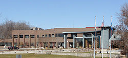 Plymouth City Hall | |
 Location of Plymouth within Hennepin County, Minnesota | |
| Coordinates: 45°00′38″N 93°27′20″W / 45.01056°N 93.45556°WCoordinates: 45°00′38″N 93°27′20″W / 45.01056°N 93.45556°W | |
| Country | United States |
| State | Minnesota |
| County | Hennepin |
| Founded | 1852 by Pete Scherer |
| Incorporated | 1858 |
| Government | |
| • Mayor | Jeffry Wosje (R)[1] |
| Area | |
| • City | 35.28 sq mi (91.38 km2) |
| • Land | 32.71 sq mi (84.72 km2) |
| • Water | 2.57 sq mi (6.66 km2) |
| Elevation | 971 ft (296 m) |
| Population | |
| • City | 70,576 |
| • Estimate (2019)[3] | 79,768 |
| • Rank | US: 438th MN: 7th |
| • Density | 2,438.57/sq mi (941.53/km2) |
| • Metro | 3,629,190 (US: 16th) |
| Time zone | UTC-6 (Central (CST)) |
| • Summer (DST) | UTC-5 (CDT) |
| ZIP codes | 55441, 55442, 55446, 55447 |
| Area code(s) | 763 |
| FIPS code | 27-51730 |
| GNIS feature ID | 0649598[5] |
| Website | plymouthmn.gov |


Plymouth is the seventh largest city in the U.S. state of Minnesota. Located 15 miles (24 km) west of downtown Minneapolis in Hennepin County, the city is the third largest suburb of Minneapolis–Saint Paul, which is the sixteenth largest metropolitan area in the United States, with about 3.63 million residents. According to the 2019 Metropolitan Council estimate, Plymouth's population is 79,768.[6] The population was 70,576 at the 2010 Census.[7] Once named for Medicine Lake, the city's name was chosen by Hennepin County Commissioners during the county's inception.[8]
History[]
This section does not cite any sources. (March 2021) |
Plymouth's history can be traced back to the pre-Columbian period around 1400 to 1500 AD. The original inhabitants were the Dakota. Their encampment was at the north end of Medicine Lake. The name Medicine Lake is derived from the Dakota word Mdewakanton, meaning "Lake of the Spirit." The Dakota named the lake after a warrior overturned his canoe and his body was never recovered.[citation needed]
Antoine LeCounte, a guide and explorer, was the first settler to this area. He arrived in 1848, but did not settle until 1852. He carried mail from the Red River country to points south, trading goods to Native Americans for horses on the way. LeCounte built the first cabin at what is now East Medicine Lake Boulevard at 29th Avenue North.
Plymouth's beginning as a town occurred in 1855 on the northwest shores of what is now known as Parkers Lake. A gristmill and other structures were built in the area. In the spring of 1857, when Parkers Lake flooded, the mill was taken down and moved to Freeport. Freeport is now named Wayzata.
As new settlers arrived in the area, they decided to organize. The Hennepin County Board of Commissioners named the new settlement Plymouth. On April 19, 1858, a group of townspeople met at the home of Francis Day to open elections for town offices. On May 11, 1858, the group voted to change the town's name to Medicine Lake. This was used once at the town meeting, but for reasons, which were not recorded, it was never used again.
During the Dakota War of 1862 between white settlers and the Dakota at Fort Ridgely, near New Ulm, the settlers of Plymouth formed a militia. When the Civil War started, Plymouth paid its volunteers $25 to enlist. At about this time, Plymouth's growth began to take on a new look. Schools and churches were built and a post office was in Plymouth. By 1863, hotels were being built.
More changes occurred after the Civil War. By 1880, Plymouth boasted a population of 1,074, and reaped $667 in annual taxes. Farming became the trade of most settlers. Roads were built across Plymouth, making access to other towns possible. Medicine Lake had become a major tourist attraction and resorts were built around its shores.
As the character of the community evolved, so did local government. Plymouth incorporated as a village on May 18, 1955. The city adopted the Council–Manager form of government on August 1, 1968. Plymouth became a statutory city on February 7, 1974. It remained a statutory city until voters opted to make it a home rule charter city by adopting a City Charter on November 3, 1992. The City Charter went into effect on January 1, 1993. The Charter continued the Council–Manager form of government, and increased the size of the City Council. Before the adoption of the Charter, the City Council was made up of five members elected at-large. The Charter increased the Council to seven members elected from four wards.
Plymouth was named by Money Magazine the number one city in which to live in the United States in 2008. The magazine gave top honors to Plymouth because of its inclusion of residential areas, industry, parks, schools, and other aspects which make Plymouth a self-contained and essentially autonomous city.
Geography[]
According to the United States Census Bureau, the city has a total area of 35.33 square miles (91.50 km2), of which 32.68 square miles (84.64 km2) is land and 2.65 square miles (6.86 km2) is water.[9]
Interstate 494, U.S. Highway 169, and Minnesota State Highway 55 are three of the main routes in the city. Plymouth has 863 cul-de-sacs and 300 miles of city streets, which are maintained by the city's public works crews.[10]
Climate[]
Plymouth has a humid continental climate, typical of the Midwestern United States, with very cold winters, and relatively hot, often humid summer days. Summer daytime temperatures average 83 °F (28 °C), with a low of around 60 °F (15 °C), while winter temperatures average only 23 °F (-5 °C) and a low of 3 °F (-16 °C). The highest recorded temperature in Plymouth was 99 °F (37 °C) in 1964, and the lowest was -39 °F (-39.4 °C) in 1977. Rain falls throughout the year, with the highest concentration falling in the summer months, with June being the rainiest with 120.3 mm of rain.
| hideClimate data for Plymouth, Minnesota | |||||||||||||
|---|---|---|---|---|---|---|---|---|---|---|---|---|---|
| Month | Jan | Feb | Mar | Apr | May | Jun | Jul | Aug | Sep | Oct | Nov | Dec | Year |
| Record high °F (°C) | 55 (13) |
59 (15) |
83 (28) |
92 (33) |
95 (35) |
102 (39) |
99 (37) |
96 (36) |
96 (36) |
87 (31) |
73 (23) |
61 (16) |
102 (39) |
| Average high °F (°C) | 23 (−5) |
29 (−2) |
41 (5) |
57 (14) |
71 (22) |
78 (26) |
83 (28) |
80 (27) |
72 (22) |
59 (15) |
41 (5) |
27 (−3) |
55 (13) |
| Average low °F (°C) | 3 (−16) |
10 (−12) |
27 (−3) |
34 (1) |
47 (8) |
56 (13) |
60 (16) |
58 (14) |
49 (9) |
37 (3) |
24 (−4) |
10 (−12) |
35 (1) |
| Record low °F (°C) | −39 (−39) |
−31 (−35) |
−27 (−33) |
−5 (−21) |
18 (−8) |
33 (1) |
42 (6) |
36 (2) |
22 (−6) |
9 (−13) |
−19 (−28) |
−33 (−36) |
−39 (−39) |
| Average precipitation inches (mm) | 0.90 (22.8) |
0.66 (16.7) |
1.68 (42.6) |
2.41 (61.2) |
3.54 (89.9) |
4.74 (120.3) |
4.16 (105.6) |
4.02 (102.1) |
3.3 (85) |
2.50 (63.5) |
1.64 (41.6) |
0.90 (22.8) |
30.45 (774.1) |
| Source: http://www.weather.com/weather/wxclimatology/monthly/graph/55447?from=tenDay_bottomnav_undeclared | |||||||||||||
Demographics[]
| Historical population | |||
|---|---|---|---|
| Census | Pop. | %± | |
| 1860 | 393 | — | |
| 1870 | 872 | 121.9% | |
| 1880 | 1,072 | 22.9% | |
| 1890 | 1,053 | −1.8% | |
| 1900 | 1,164 | 10.5% | |
| 1910 | 1,221 | 4.9% | |
| 1920 | 1,275 | 4.4% | |
| 1930 | 1,683 | 32.0% | |
| 1940 | 2,989 | 77.6% | |
| 1950 | 5,813 | 94.5% | |
| 1960 | 9,576 | 64.7% | |
| 1970 | 18,077 | 88.8% | |
| 1980 | 31,615 | 74.9% | |
| 1990 | 50,889 | 61.0% | |
| 2000 | 65,894 | 29.5% | |
| 2010 | 70,576 | 7.1% | |
| 2020 | 81,026 | 14.8% | |
| U.S. Decennial Census[11] 2018 Estimate[12] | |||
According to a 2007 estimate, the median income for a household in the city was $80,949, and the median income for a family was $101,630.
2000 census[]
As of the census of 2000, there were 65,894 people, 24,820 households, and 17,647 families living in the city. The population density was 2,002.0 persons per square mile (773.1/km2). There were 25,258 housing units at an average density of 767.4 per square mile (296.3/km2). The racial makeup of the city was 91.36% White, 2.71% African American, 0.33% Native American, 3.79% Asian, 0.01% Pacific Islander, 0.50% from other races, and 1.31% from two or more races. Hispanic or Latino of any race were 1.64% of the population. 27.0% were of German, 13.1% Norwegian, 7.8% Irish and 7.5% Swedish ancestry.
There were 24,820 households, out of which 37.8% had children under the age of 18 living with them, 61.2% were married couples living together, 7.6% had a female householder with no husband present, and 28.9% were non-families. 21.8% of all households were made up of individuals, and 4.7% had someone living alone who was 65 years of age or older. The average household size was 2.60 and the average family size was 3.09.
In the city, the population was spread out, with 27.1% under the age of 18, 7.4% from 18 to 24, 33.0% from 25 to 44, 25.0% from 45 to 64, and 7.6% who were 65 years of age or older. The median age was 36 years. For every 100 females, there were 97.1 males. For every 100 females age 18 and over, there were 95.5 males.
The median income for a household in the city was $77,008, and the median income for a family was $90,134. Males had a median income of $59,751 versus $38,111 for females. The city's per capita income was $36,309. About 1.5% of families and 2.6% of the population were below the poverty line, including 2.0% of those under age 18 and 1.5% of those age 65 or over.
2010 census[]
As of the census[4] of 2010, there were 70,576 people, 28,663 households, and 19,230 families living in the city. The population density was 2,159.6 inhabitants per square mile (833.8/km2). There were 29,982 housing units at an average density of 917.4 per square mile (354.2/km2). The city's racial makeup was 84.2% White, 5.2% African American, 0.3% Native American, 6.9% Asian, 1.0% from other races, and 2.3% from two or more races. Hispanic or Latino of any race were 3.0% of the population.
There were 28,663 households, of which 32.4% had children under the age of 18 living with them, 55.6% were married couples living together, 8.5% had a female householder with no husband present, 3.0% had a male householder with no wife present, and 32.9% were non-families. 26.4% of all households were made up of individuals, and 8% had someone living alone who was 65 years of age or older. The average household size was 2.42 and the average family size was 2.96.
The median age in the city was 39.5 years. 23.9% of residents were under the age of 18; 6.9% were between the ages of 18 and 24; 27.1% were from 25 to 44; 30.1% were from 45 to 64; and 12.1% were 65 years of age or older. The gender makeup of the city was 48.4% male and 51.6% female.
Government and politics[]
Plymouth operates under a council-manager form of government. The council comprises a mayor and six council members.[1]
Plymouth is an independent district currently represented by state senators Ann Johnson Stewart (D), and Ron Latz (D). Plymouth's state representatives are Democrats Ryan Winkler, Ginny Klevorn Carlson, and Patty Acomb. Plymouth is in Minnesota's 3rd congressional district and is currently represented by Democrat Dean Phillips in the U.S. House of Representatives.
| Plymouth Election results from statewide races | ||
|---|---|---|
| Year | Office | Results |
| 2018 | Governor | Walz 56.47 – 40.92% |
| U.S. Senator | Klobuchar 65.00 – 32.86% | |
| U.S. Senator | Smith 56.31 – 40.53% | |
| U.S. Representative | Phillips 57.77 – 42.06% | |
| 2016 | President | Clinton 53.32 – 37.74% |
| U.S. Representative | Paulsen 53.85 – 45.89% | |
| 2014 | Governor | Johnson 49.59 – 47.08% |
| U.S. Senator | Franken 49.59 – 48.04% | |
| U.S. Representative | Paulsen 61.68 – 38.22% | |
| 2012 | President | Obama 50.07 – 48.13% |
| U.S. Senator | Klobuchar 63.33 – 34.05% | |
| U.S. Representative | Paulsen 57.92 – 41.97% | |
| Amendment 1 | No 59.40 – 40.60% | |
| 2010 | Governor | Emmer 48.25 – 37.19 – 14.05% |
| U.S. Representative | Paulsen 60.00 – 35.90% | |
| 2008 | President | Obama 52.10 – 46.44% |
| U.S. Senator | Coleman 48.53 – 37.11 – 13.73% | |
| U.S. Representative | Paulsen 49.92 – 40.15 – 9.83% | |
| 2006 | Governor | Pawlenty 54.99 – 38.16 – 6.19% |
| U.S. Senator | Klobuchar 55.17 – 41.83% | |
| U.S. Representative | Ramstad 68.94 – 30.96% | |
| 2004 | President | Bush 51.90 – 47.17% |
| U.S. Representative | Ramstad 67.61 – 32.32% | |
| 2002 | Governor | Pawlenty 52.71 – 30.84% – 14.59% |
| U.S. Senator | Coleman 59.10 – 38.96% | |
| U.S. Representative | Ramstad 76.78 – 23.15% | |
| 2000 | President | Bush 51.60 – 44.27% |
| U.S. Senator | Grams 48.59 – 43.48 –6.67% | |
| U.S. Representative | Ramstad 72.23 – 25.78% | |
Education[]
Public schools[]
Five school districts serve Plymouth, Wayzata Public Schools (ISD 284), Robbinsdale Area Schools (ISD 281), Osseo School District (279), West Metro Education Program (ISD 6069) and Hopkins School District (ISD 270). The majority of the city, particularly the western, northwestern, and southern areas, is served by Wayzata Public Schools. Robbinsdale Area Schools serves the east-central area of Plymouth. The Osseo District includes the northeast area and Hopkins includes the southeast corner of Plymouth. Some students attend public schools in other school districts chosen by their families under Minnesota's open enrollment statute.[13]
- Birchview Elementary School
- Fair School Pilgrim Lane
- Gleason Lake Elementary School
- Greenwood Elementary School
- Kimberly Lane Elementary School
- Meadow Ridge Elementary School
- North Woods Elementary School
- Oakwood Elementary School
- Plymouth Creek Elementary School
- Plymouth Middle School
- Robbinsdale Armstrong High School
- Sunset Hill Elementary School
- Wayzata East Middle School
- Wayzata Central Middle School
- Wayzata West Middle School
- Wayzata High School
- Zachary Lane Elementary School
Wayzata High School is operated by the Wayzata School District, has approximately 3500 students in grades 9 to 12 (2011), making it the largest secondary school by enrollment in Minnesota. Projected enrollment for the 2012-2013 School Year is 3617. It is also the largest Minnesota secondary school by structural size, with an interior of 487,000 square feet (45,200 m2). The school is part of the Lake Conference. In 2008, Newsweek ranked the school #940 "List of the 1300 Top High Schools in America."
Robbinsdale School District
- Robbinsdale Armstrong High School
- Robbinsdale Plymouth Middle School
- Fair School Pilgrim Lake
- Zachary Lane Elementary School
West Metro Education Program (WMEP) District 6069
Private schools and colleges[]
- Association Free Lutheran Bible School and Seminary
- Fourth Baptist Christian School
- Central Baptist Theological Seminary
- Providence Academy
- West Lutheran High School
Economy[]
OneBeacon, Select Comfort, Christopher & Banks and Tonka Water are headquartered in Plymouth.
Principal employers[]
According to Plymouth's 2014 Comprehensive Annual Financial Report,[14] the principal employers in the city are:
| # | Employer | # of Employees |
|---|---|---|
| 1 | Wayzata Public Schools | 1,505 |
| 2 | Aimia | 1,000 |
| 3 | Select Comfort | 900 |
| 4 | Medtronic | 875 |
| 5 | St. Jude Medical | 800 |
| 6 | Prudential | 598 |
| 7 | City of Plymouth | 571 |
| 8 | Honeywell | 525 |
| 9 | Nilfisk-Advance | 500 |
| 10 | US Foods | 500 |
Notable people[]
- Marion Barber III – former NFL running back
- Rudy Boschwitz – US Senator who while serving in office also lived in Plymouth.[15]
- Ariya Daivari – Professional wrestler signed to WWE
- Jonas H. Howe – abolitionist, artist, and state legislator
- Jeff Johnson – Hennepin County Commissioner
- Evan Kaufmann (born 1984) – professional ice hockey player in Germany
- Amy Klobuchar – US Senator and 2020 Democratic presidential candidate
- James Laurinaitis – NFL linebacker
- Mark Parrish – former NHL All Star
- Andrew Tang - chess grandmaster
- A.J. Tarpley – NFL linebacker with the Buffalo Bills
- Blake Wheeler – NHL player
- Dani Cameranesi - Former Olympic Gold Medalist
References[]
- ^ Jump up to: a b "City Council Members". City of Plymouth. Retrieved January 3, 2019.
- ^ "2019 U.S. Gazetteer Files". United States Census Bureau. Retrieved July 26, 2020.
- ^ "Population and Housing Unit Estimates". United States Census Bureau. May 24, 2020. Retrieved May 27, 2020.
- ^ Jump up to: a b "U.S. Census website". United States Census Bureau. Retrieved November 13, 2012.
- ^ "US Board on Geographic Names". United States Geological Survey. October 25, 2007. Retrieved January 31, 2008.
- ^ "Population and Housing Unit Estimates". Retrieved May 21, 2020.
- ^ "2010 Census Redistricting Data (Public Law 94-171) Summary File". American FactFinder. U.S. Census Bureau, 2010 Census. Retrieved April 23, 2011.[dead link]
- ^ "City of Plymouth, Minnesota". plymouth.mn.us. Archived from the original on September 25, 2006. Retrieved April 2, 2018.
- ^ "US Gazetteer files 2010". United States Census Bureau. Archived from the original on January 25, 2012. Retrieved November 13, 2012.
- ^ "Streets - City of Plymouth, MN". www.ci.plymouth.mn.us. Retrieved April 2, 2018.
- ^ United States Census Bureau. "Census of Population and Housing". Retrieved June 15, 2013.
- ^ "Population Estimates". United States Census Bureau. Retrieved July 14, 2019.
- ^ "Open Enrollment". Minnesota Department of Education. Archived from the original on August 26, 2010. Retrieved November 19, 2010.
- ^ "City of Plymouth CAFR". plymouthmn.gov. Retrieved April 2, 2018.
- ^ Barone, Michael; Ujifusa, Grant (1987). The Almanac of American Politics 1988. National Journal. p. 628.
External links[]
- City website
- U.S. Geological Survey Geographic Names Information System: Plymouth
- Movies and television shows filmed in Plymouth
| show Municipalities and communities of Hennepin County, Minnesota, United States |
|---|


| show Authority control |
|---|
- Plymouth, Minnesota
- Cities in Minnesota
- Cities in Hennepin County, Minnesota
- Populated places established in 1852
- 1852 establishments in Minnesota Territory