Fort Snelling unorganized territory
Fort Snelling unorganized territory | |
|---|---|
Unincorporated district of Hennepin County | |
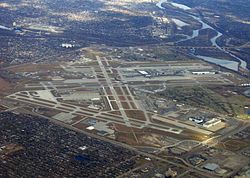 Aerial photograph of Minneapolis–St. Paul International Airport showing much of the unorganized territory of Fort Snelling. The historic fort is by the confluence of the Mississippi and Minnesota toward the upper right of the photograph, and Fort Snelling National Cemetery is at center right. | |
 Fort Snelling unorganized territory Location within the state of Minnesota | |
| Coordinates: 44°53′34″N 93°10′50″W / 44.89278°N 93.18056°WCoordinates: 44°53′34″N 93°10′50″W / 44.89278°N 93.18056°W | |
| Country | United States |
| State | Minnesota |
| County | Hennepin County |
| Time zone | UTC-6 (Central (CST)) |
| • Summer (DST) | UTC-5 (CDT) |

Fort Snelling unorganized territory is an unincorporated area under the jurisdiction of Hennepin County in the U.S. state of Minnesota that is named after historic Fort Snelling, which is located within its boundaries.[1] The district also includes Coldwater Spring park, Minneapolis-Saint Paul International Airport, parts of the Mississippi National River and Recreation Area, and several government facilities. As of the 2020 census the territory had a population of 322 people.
Geography[]
The unorganized territory of Fort Snelling is a division of Hennepin County lying just east of the city of Richfield. Historic Fort Snelling is located at the eastern end of the territory, near the confluence of the Mississippi River with the Minnesota River. Within Hennepin County it also borders Minneapolis to the north and Bloomington to the southwest, while across the Mississippi River is Saint Paul in Ramsey County, and across the Minnesota River are Mendota and Mendota Heights in Dakota County.
For postal purposes, the eastern portion addresses in the unorganized territory (including Terminal 1 of the Minneapolis St. Paul International Airport and the Fort Snelling historic site) are in zip code 55111 with a Saint Paul mailing address, while addresses in the western part of the territory (including the airport's Terminal 2 and the Metropolitan Airports Commission offices) are in zip code 55450 and have a Minneapolis mailing address.[2] According to the United States Census Bureau, this unorganized territory has a total area of 17.2 km2 (6.7 mi2). 16.5 km2 (6.4 mi2) of it is land and 0.8 km2 (0.3 mi2) of it is water.
Fort Snelling's territory contains numerous military and other federal facilities. These facilities include the current National Guard base at Fort Snelling, Fort Snelling National Cemetery, and the Minneapolis Veterans Health Administration Medical Center.
Several facilities belonging to Minnesota state government agencies such as the Minnesota Department of Transportation are also located in the territory, as are the headquarters and portions of Fort Snelling State Park and the Minnesota Valley National Wildlife Refuge.
Minneapolis-Saint Paul International Airport, however, includes most of the land area of the unorganized territory. Delta Air Lines Building C is located on the property of Minneapolis–St. Paul International Airport and in Fort Snelling.[3][4][5][6] Delta uses it for northern and regional operations.[7]
Demographics[]
| Historical population | |||
|---|---|---|---|
| Census | Pop. | %± | |
| 1880 | 352 | — | |
| 1890 | 550 | 56.3% | |
| 1930 | 2,043 | — | |
| 1940 | 2,972 | 45.5% | |
| 1950 | 2,584 | −13.1% | |
| 1960 | 898 | −65.2% | |
| 1970 | 624 | −30.5% | |
| 1980 | 223 | −64.3% | |
| 1990 | 97 | −56.5% | |
| 2000 | 442 | 355.7% | |
| 2010 | 149 | −66.3% | |
| 2020 | 322 | 116.1% | |
| U.S. Decennial Census[8] | |||
Fort Snelling was listed as an incorporated village during the 1890 Census.[8]
Most people resident in the unorganized territory are service members stationed at the barracks at Fort Snelling.[citation needed] The number of troops stationed there has declined over the years; for example, between the 2000 and 2010 censuses the population dropped from 442 to 149. Since then, however, a small amount of private housing in the old fort's Upper Post area has been developed or planned, so the population may increase again.
As of the census[9] of 2020, 322 people resided in 239 households in the unorganized territory. Of these, 20.7% were naturalized American citizens and 70.3% were not American citizens. 83.5% of households spoke English at home and 14.6% spoke Spanish. The median household income was $18,594. 31.1% of the population was below the poverty line.
References[]
- ^ "Unorganized Territory Of Fort Snelling MN Demographic Data and Boundary Map". minnesota.hometownlocator.com. Retrieved 2020-11-02.
- ^ "Minnesota Zip Code Boundary Map (MN)". www.zipmap.net. Retrieved 2018-03-04.
- ^ "delta air lines' farmers market-building c". Minneapolis–St. Paul International Airport. Retrieved on January 19, 2012. "Location: MSP Airport-Delta Building C, North Side near Compass Airlines Entrance"
- ^ "Fort Snelling UT, Hennepin county, Minnesota". (Archive) U.S. Census Bureau. Retrieved on December 19, 2009.
- ^ "Expanded Branch and ATM Access Comes to the Twin Cities Archived 2012-03-18 at the Wayback Machine". Wings Financial. Retrieved on January 19, 2012. "Delta Air Lines Bldg. C* 7500 Airline Drive Minneapolis, MN"
- ^ "Blood Drive | Delta Air Lines Bldg C". Memorial Blood Centers. Retrieved on January 19, 2012. "Street: 7500 Airline Drive City: Bloomington State: Minnesota Country: USA"
- ^ Niemela, Jennifer. "Delta reaches deal on Minnesota jobs". Minneapolis / St. Paul Business Journal. Tuesday December 16, 2008. Retrieved on January 19, 2012.
- ^ Jump up to: a b United States Census Bureau. "Census of Population and Housing". Retrieved July 23, 2014.
- ^ "U.S. Census website". United States Census Bureau. Retrieved 2021-09-03.
| show Municipalities and communities of Hennepin County, Minnesota, United States |
|---|

- Mississippi National River and Recreation Area
- Unorganized territories in Minnesota
- Populated places in Hennepin County, Minnesota
- Minnesota populated places on the Mississippi River
- Former municipalities in Minnesota