Dayton, Minnesota
Dayton | |
|---|---|
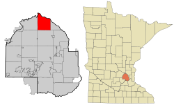 Location of the city of Dayton within Hennepin County, Minnesota | |
| Coordinates: 45°12′N 93°30′W / 45.200°N 93.500°W | |
| Country | United States |
| State | Minnesota |
| Counties | Hennepin, Wright |
| Government | |
| • Mayor | Dennis Fisher |
| Area | |
| • City | 25.18 sq mi (65.22 km2) |
| • Land | 23.42 sq mi (60.65 km2) |
| • Water | 1.76 sq mi (4.57 km2) |
| Elevation | 879 ft (268 m) |
| Population | |
| • City | 4,671 |
| • Estimate (2019)[5] | 6,686 |
| • Density | 285.49/sq mi (110.23/km2) |
| • Metro | 2,968,805 |
| Time zone | UTC-6 (Central) |
| • Summer (DST) | UTC-5 (Central) |
| ZIP codes | 55327, 55369 |
| Area code(s) | 763 |
| FIPS code | 27-15022[3] |
| GNIS feature ID | 0642665[4] |
| Website | www.cityofdaytonmn.com |

Dayton is a city in Hennepin and Wright counties in the U.S. state of Minnesota. The population was 4,671 at the 2010 census.[6] Dayton is mainly located within Hennepin County, but a part of the city extends into Wright County as well. It is the northernmost city in Hennepin County and is a suburb of the Minneapolis- St Paul “Twin Cities” metropolitan area.
The city of Dayton, platted in 1855, is named for city founder, Lyman Dayton. Through his energy and finances, Lyman Dayton was instrumental in bringing the railroad into Minnesota and development of the Lake Superior and Mississippi Railroad, of which he was President until 1865.[7] The line is now part of the Burlington Northern Santa Fe Railroad.
Geography[]
According to the United States Census Bureau, the city has a total area of 25.15 square miles (65.14 km2), of which 23.25 square miles (60.22 km2) is land and 1.90 square miles (4.92 km2) is water.[8] On January 15, 2003 the city's most recent geographical expanse extended its boundaries.
Fernbrook Lane (County 121); North Diamond Lake Road (County 144); South Diamond Lake Road; and Dayton River Road (County 12) are four of the main routes in Dayton. Interstate 94 and County Road 81 pass briefly through the southwest corner of Dayton. Brockton Lane (County 13) runs north–south along Dayton's western boundary line with adjacent city of Rogers.
The neighboring cities are Champlin, Rogers, Maple Grove, Anoka, Ramsey, Elk River, and Otsego. Corcoran is nearby, but does not border Dayton.
Dayton is located at the confluence of the Mississippi and Crow Rivers.
Economy[]
Dayton is a small town in regards to the economy scale with few retail outlets. Dayton's economy comes from mostly small business operations such as Two golf courses, various car repair shops, famous local manor, and custom home builders. Until October 2013, it was also home to a PDQ convenience store.
City Government[]
In 2011, the City was forced to lay off several staff members and reduce services due to budget cuts.
Demographics[]
| Historical population | |||
|---|---|---|---|
| Census | Pop. | %± | |
| 1880 | 255 | — | |
| 1910 | 343 | — | |
| 1920 | 299 | −12.8% | |
| 1930 | 265 | −11.4% | |
| 1940 | 253 | −4.5% | |
| 1950 | 363 | 43.5% | |
| 1960 | 456 | 25.6% | |
| 1970 | 517 | 13.4% | |
| 1980 | 4,070 | 687.2% | |
| 1990 | 4,443 | 9.2% | |
| 2000 | 4,699 | 5.8% | |
| 2010 | 4,671 | −0.6% | |
| 2020 | 7,212 | 54.4% | |
| U.S. Decennial Census[9] | |||
| Historical population | |||
|---|---|---|---|
| Census | Pop. | %± | |
| 1860 | 540 | — | |
| 1870 | 951 | 76.1% | |
| 1880 | 1,197 | 25.9% | |
| 1890 | 1,075 | −10.2% | |
| 1900 | 1,138 | 5.9% | |
| 1910 | 778 | −31.6% | |
| 1920 | 744 | −4.4% | |
| 1930 | 718 | −3.5% | |
| 1940 | 741 | 3.2% | |
| 1950 | 715 | −3.5% | |
| 1960 | 804 | 12.4% | |
| 1970 | 2,162 | 168.9% | |
| U.S. Census for Dayton Township[9] | |||
2010 census[]
As of the census[2] of 2010, there were 4,671 people, 1,638 households, and 1,319 families living in the city. The population density was 200.9 inhabitants per square mile (77.6/km2). There were 1,699 housing units at an average density of 73.1 per square mile (28.2/km2). The racial makeup of the city was 93.7% White, 0.5% African American, 0.2% Native American, 2.0% Asian, 0.1% Pacific Islander, 1.8% from other races, and 1.7% from two or more races. Hispanic or Latino of any race were 8.8% of the population.
There were 1,638 households, of which 35.5% had children under the age of 18 living with them, 66.8% were married couples living together, 7.4% had a female householder with no husband present, 6.3% had a male householder with no wife present, and 19.5% were non-families. 14.3% of all households were made up of individuals, and 4.2% had someone living alone who was 65 years of age or older. The average household size was 2.85 and the average family size was 3.12.
The median age in the city was 41.7 years. 24.6% of residents were under the age of 18; 8.2% were between the ages of 18 and 24; 22.5% were from 25 to 44; 35.7% were from 45 to 64; and 9% were 65 years of age or older. The gender makeup of the city was 52.2% male and 47.8% female.
2000 census[]
As of the census of 2000,[3] there were 4,699 people, 1,550 households, and 1,292 families living in the city. The population density was 200.4 people per square mile (77.4/km2). There were 1,566 housing units at an average density of 66.8 per square mile (25.8/km2). The racial makeup of the city was 95.28% White, 0.64% African American, 0.64% Native American, 0.81% Asian, 1.87% from other races, and 0.77% from two or more races. Hispanic or Latino of any race were 2.75% of the population. 31.6% were of German, 13.5% Swedish, 11.0% Norwegian and 7.9% Irish ancestry.
There were 1,550 households, out of which 45.7% had children under the age of 18 living with them, 71.9% were married couples living together, 7.9% had a female householder with no husband present, and 16.6% were non-families. 11.7% of all households were made up of individuals, and 2.1% had someone living alone who was 65 years of age or older. The average household size was 3.03 and the average family size was 3.29.
In the city, the population was spread out, with 30.5% under the age of 18, 7.8% from 18 to 24, 33.2% from 25 to 44, 23.7% from 45 to 64, and 4.7% who were 65 years of age or older. The median age was 35 years. For every 100 females, there were 103.1 males. For every 100 females age 18 and over, there were 105.1 males.
The median income for a household in the city was $66,875, and the median income for a family was $71,356. Males had a median income of $41,476 versus $30,386 for females. The per capita income for the city was $27,756. About 1.0% of families and 2.7% of the population were below the poverty line, including 3.7% of those under age 18 and none of those age 65 or over.
Politics[]
From 1960 to 1996, Dayton was a Democrat Stronghold, having voted Democrat in every election except for 1984 when it voted narrowly for then incumbent Ronald Reagan, who won in a landslide over Minnesota Senator Walter Mondale. Since 2000 however, the city hsa drifted more and more Republican, having voted Republican in every election at the presidential level since 2000 when it voted by 12% for George W. Bush. The city was last won by Donald Trump in 2020.
Points of interest[]
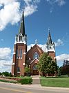
St. John the Baptist Catholic Church, constructed in 1904, can be seen for miles and from four different counties.
References[]
- ^ "2019 U.S. Gazetteer Files". United States Census Bureau. Retrieved July 26, 2020.
- ^ Jump up to: a b "American FactFinder". United States Census Bureau. Archived from the original on 2020-02-12. Retrieved 2012-11-13.
- ^ Jump up to: a b "American FactFinder". United States Census Bureau. Archived from the original on 2020-02-12. Retrieved 2008-01-31.
- ^ "US Board on Geographic Names". United States Geological Survey. 2007-10-25. Retrieved 2008-01-31.
- ^ "Population and Housing Unit Estimates". United States Census Bureau. May 24, 2020. Retrieved May 27, 2020.
- ^ "2010 Census Redistricting Data (Public Law 94-171) Summary File". American FactFinder. U.S. Census Bureau, 2010 Census. Retrieved 23 April 2011.[dead link]
- ^ Upham, Warren (1920). Minnesota Geographic Names: Their Origin and Historic Significance. Minnesota Historical Society. p. 221.
- ^ "US Gazetteer files 2010". United States Census Bureau. Archived from the original on 2012-01-24. Retrieved 2012-11-13.
- ^ Jump up to: a b "Census of Population and Housing". Census.gov. Archived from the original on May 12, 2015. Retrieved May 4, 2019.
- ^ "Minnesota Secretary of State - 2020 Precinct Results Spreadsheet".
- ^ "Minnesota Secretary of State - 2016 Precinct Results Spreadsheet".
- ^ "Minnesota Secretary of State - 2012 Precinct Results Spreadsheet".
- ^ "Minnesota Secretary of State - 2008 Precinct Results Spreadsheet".
- ^ "Minnesota Secretary of State - 2004 Precinct Results Spreadsheet".
- ^ "Minnesota Secretary of State - 2000 Precinct Results Spreadsheet".
- ^ (PDF) https://www.lrl.mn.gov/archive/sessions/electionresults/1996-11-05-g-sec.pdf. Missing or empty
|title=(help) - ^ (PDF) https://www.lrl.mn.gov/archive/sessions/electionresults/1992-11-03-g-sec.pdf. Missing or empty
|title=(help) - ^ (PDF) https://www.lrl.mn.gov/archive/sessions/electionresults/1988-11-08-g-sec.pdf. Missing or empty
|title=(help) - ^ (PDF) https://www.lrl.mn.gov/archive/sessions/electionresults/1984-11-06-g-sec.pdf. Missing or empty
|title=(help) - ^ (PDF) https://www.lrl.mn.gov/archive/sessions/electionresults/1980-11-04-g-sec.pdf. Missing or empty
|title=(help) - ^ (PDF) https://www.lrl.mn.gov/archive/sessions/electionresults/1976-11-02-g-sec.pdf. Missing or empty
|title=(help) - ^ (PDF) https://www.lrl.mn.gov/archive/sessions/electionresults/1968-11-05-g-man.pdf. Missing or empty
|title=(help) - ^ (PDF) https://www.lrl.mn.gov/archive/sessions/electionresults/1964-11-03-g-man.pdf. Missing or empty
|title=(help) - ^ (PDF) https://www.lrl.mn.gov/archive/sessions/electionresults/1960-11-08-g-man.pdf. Missing or empty
|title=(help)
External links[]
| show Municipalities and communities of Hennepin County, Minnesota, United States |
|---|

| show Municipalities and communities of Wright County, Minnesota, United States |
|---|

| show Authority control |
|---|
- Cities in Hennepin County, Minnesota
- Cities in Wright County, Minnesota
- Cities in Minnesota
- Minnesota populated places on the Mississippi River
- Populated places established in 1855
- 1855 establishments in Minnesota Territory