Iron Range
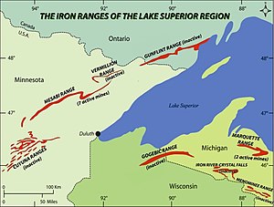
The term Iron Range refers collectively or individually to a number of elongated iron-ore mining districts around Lake Superior in the United States and Canada. Despite the word "range", the iron ranges are not mountain chains, but outcrops of Precambrian sedimentary formations containing high percentages of iron.[1] These cherty iron ore deposits are Precambrian in age for the Vermilion Range and middle Precambrian in age for the Mesabi and Cuyuna ranges, all in Minnesota. The Gogebic Range in Wisconsin and the Marquette Iron Range and Menominee Range in Michigan have similar characteristics and are of similar age. Natural ores and concentrates were produced from 1848 until the mid 1950s, when taconites and jaspers were concentrated and pelletized, and started to become the major source of iron production.[2]
The region's far eastern area, containing the Duluth Complex along the shore of Lake Superior, and the far northern area, along the Canada–US border, are not associated with iron ore mining. Due to its shape, the area is collectively known as the Arrowhead region of Minnesota. It consists of seven counties: Aitkin, Carlton, Cook, Itasca, Koochiching, Lake, and Saint Louis.
The Iron Range and its economy[]


From a geological perspective, Minnesota's Iron Range includes these four major iron deposits:[3]
- Mesabi Range, the largest iron range, largely within Itasca and Saint Louis counties;
- Vermilion Range, northeast of the Mesabi, in Saint Louis and Lake counties;
- Gunflint Range , in the extreme northern portion of Cook County and extending into Canada; and
- Cuyuna Range, southwest of the Mesabi, largely within Crow Wing County.
Within Minnesota, "The Iron Range Resources and Rehabilitation is a State Department, established by the legislature of 1941 to render public service through research and the actual development of all the state's resources both natural and human."[4] The Iron Range Resources and Rehabilitation Board (IRRRB), known as "the I-triple-R-B" or Iron Range Resources,[5] is an economic development agency funded partly by state taxes on taconite-producing companies and charged with creating jobs.
History[]
Geologically, the iron ranges in Minnesota belong to the Animikie Group. The geologic history of the formations containing iron are typical of banded iron formations worldwide.[2]: 502–504
Before the 19th century, Native American groups mined native copper on the Keweenaw Peninsula[citation needed]. William Austin Burt discovered iron ore in the Marquette Range near Negaunee, Michigan in 1844. Iron ore was discovered on the Menominee Range in 1867, on the Gogebic Range in 1884, on the Vermilion Range in 1885, the Mesabi Range in 1890, and the Cuyuna Range in 1903.[2]
Underground mines were developed to remove the valuable ore of most ranges. But on the Mesabi and Cuyuna Ranges, iron mining operations evolved into enormous open pit mines, where steamshovels and other industrial machines could remove massive amounts of ore. "Large-scale commercial production of magnetite taconite ore on the Mesabi Range started in 1956 at the Peter Mitchell Mine near Babbitt, Minnesota."[2]
Cities[]
The Iron Range contains several smaller towns. Some of the more significant communities in the region include:
A large part of the Iron Range is also included in the Duluth MN-WI MSA.
- Aitkin (pop. 2,165) is on the Cuyuna Range 's eastern edge.
- Aurora (pop. 1,853) is on the Eastern Mesabi Range. The former St. James, Meadow, Miller and Stephens mines lie within the city limits.
- Babbitt (pop. 1,475)
- Biwabik (pop. 969)
- Bovey (pop. 804) is along U.S. Highway 169 between Coleraine and Taconite .
- Buhl (pop. 1,000) is along U.S. Highway 169 between Chisholm and Virginia.
- Chisholm (pop. 4,976) is the Mesabi Range's geographic center.
- Coleraine (pop. 1,970) has been called the "start place of the Iron Range."
- Crosby (pop. 2,386) is an old mining boomtown on the Iron Range's southwestern edge.
- Duluth (pop. 86,265) The fourth largest city in the state, while not part of the Iron Range, is a destination for much of its production shipped via the DM&IR railroad.
- Deerwood (pop. 529) Mining engineer Cuyler Adams discovered the Cuyuna Range near Deerwood in 1895.
- Ely (pop. 3,460), in the Vermillion Range, is perhaps best known as the most popular entry point for the Boundary Waters Canoe Area Wilderness.
- Eveleth (pop. 3,718) Home of the U.S. Hockey Hall of Fame
- Grand Rapids (pop. 10,869) is named for the local rapids in the Mississippi River.
- Gilbert (pop. 1,799) is the location of Lake Ore-be-gone, an artificial lake created by flooding three open-pit iron ore mines.
- Grand Marais (pop. 1,351) The area was a bustling fur trading station since the 1700s, and the French voyageurs called the settled village Grand Marais ("Great Marsh"), referring to a marsh that in early fur-trading times was 20 acres (8.1 ha) or less in area, nearly at the level of Lake Superior, and situated at the head of the little bay and harbor that led to the settlement of the village. The town comprises much of the Gunflint Trail, which extends to the former Paulson Mine site.
- Hibbing (pop. 16,361) is the largest city by area in the state of Minnesota. It is home to the Hull–Rust–Mahoning Open Pit Iron Mine, one of the world's largest open pit iron mines.
- Hoyt Lakes (pop. 1,888) is in the eastern Mesabi Range. Erie Mining Company previously mined ore and testing to mine new minerals is ongoing.
- Keewatin (pop. 1,068) is between Nashwauk and Hibbing. It is home to U.S. Steel's KeeTac taconite mining and processing plant.
- Kinney (pop. 169) is an old mining boomtown on the Iron Range, between Buhl and Mountain Iron.
- Mountain Iron (pop. 2,869) is home to Minntac, the world's largest taconite processing plant.
- Nashwauk (pop. 983) is a small town between Grand Rapids and Hibbing, 4 miles from Keewatin.
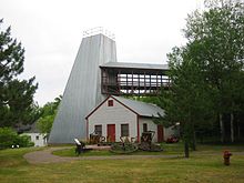
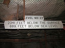
- Soudan is an unincorporated community in Breitung Township, Saint Louis County immediately east of the city of Tower on Minn.Highway 169 / Minn.Highway 1. It is the home of the Soudan Underground Mine State Park , which contained the University of Minnesota's Soudan Underground Laboratory, which housed detectors, including MINOS, over 700 meters below the earth's surface.
- Taconite (pop. 360), named after the taconite pellets from iron ore, was a town many miners lived in.
- Two Harbors (pop. 3,745) is the county seat of Lake County, along the shore of Lake Superior. The town was historically an important port for loading and shipping iron ore from the Range.
- Virginia (pop. 8,712) is next to the Rouchleau mine pit , which is nearly three miles long, a half-mile wide and 450 feet deep.
- Winton (pop 172). Once several times larger than Ely, Winton sits just 3 miles north of Ely, and was once home to a very large lumber mill and a lumber boomtown.
Culture[]
The area has Finnish, Italian, Slavic, and Scandinavian/Nordic heritage, with immigration strongly linked to the mining industry. A noticeable northern Minnesota accent is present in the area, especially among older people, hence the popular nickname "Da Range"[citation needed]. Ice hockey is a predominant sport in the region, which has produced several NHL players as well as all three members of the "" from the 1980 U.S.A. Hockey Miracle on Ice team.
The regional culture is strongly linked to former periods of steady, usually well-paid mining employment, although in recent decades, the region's outdoor recreation and relative remoteness has attracted new residents unconnected to the industry.[6] There are tensions between supporters and detractors of mining, especially over the potential reuse of ironworks to exploit copper ores. Bob Dylan, who grew up in Hibbing, memorialized the Iron Range in the 1963 song "North Country Blues", a lament portraying hard times in the region. Presented in his 1964 album The Times They Are a-Changin', it includes such lines as:
- So the mining gates locked and the red iron rotted
- And the room smelled heavy from drinking
- When the sad, silent song made the hour twice as long
- As I waited for the sun to go sinking [7]
The Iron Range is known for Cornish pasties stuffed with a combination of ground beef and pork, rutabaga, onion, carrots, and potatoes. Pasties were an easy lunch for those working deep in the iron mines.[8] Slovenian and Croatian immigrants brought the honey-nut bread potica to the Iron Range; it is still served on Easter and Christmas in northern Minnesota.[9]
Politics[]
| Year | Democratic | Republican | Others |
|---|---|---|---|
| 2020 | 51.9% 100,997 | 45.8% 89,032 | 2.3% 4,387 |
| 2016 | 47.6% 85,673 | 43.8% 78,884 | 8.6% 15,465 |
| 2012 | 60.7% 111,518 | 36.7% 67,422 | 2.6% 4,747 |
| 2008 | 62.0% 116,749 | 35.6% 67,027 | 2.3% 4,411 |
| 2004 | 61.7% 116,856 | 37.0% 70,024 | 1.3% 2,521 |
| 2000 | 56.2% 94,923 | 36.5% 61,581 | 7.3% 12,277 |
| 1996 | 58.1% 91,333 | 27.5% 43,194 | 14.5% 22,749 |
| 1992 | 53.7% 90,464 | 24.3% 40,901 | 22.0% 37,034 |
| 1988 | 65.0% 102,348 | 34.0% 53,552 | 1.0% 1,631 |
| 1984 | 65.2% 112,105 | 34.0% 58,455 | 0.9% 1,497 |
| 1980 | 58.2% 102,952 | 32.2% 56,925 | 9.6% 16,975 |
| 1976 | 64.6% 110,411 | 32.2% 55,064 | 3.2% 5,518 |
| 1972 | 56.4% 87,367 | 42.0% 64,982 | 1.6% 2,550 |
| 1968 | 69.2% 104,151 | 26.9% 40,457 | 3.9% 5,806 |
| 1964 | 75.3% 116,567 | 24.4% 37,734 | 0.3% 520 |
| 1960 | 62.0% 99,703 | 37.5% 60,283 | 0.5% 801 |
The area has remained a Democratic-Farmer-Labor Party stronghold despite its predominantly white and rural population because of its history of a largely unionized workforce in the mining industry, the mainstay of the economy of the Iron Range. In 2004, John Kerry carried most of the counties in the region by a comfortable margin. This was perhaps aided by George W. Bush calling the area the "Iron Ridge" in a campaign speech. Barack Obama outperformed McCain in 2008, carrying every county in the Range. The area was the largest rural Democratic stronghold in Minnesota outside of the urban centers in Minneapolis and St. Paul. In 2016, Donald Trump's populist economic policies changed the Range's electoral profile. He won multiple counties, reduced past Democratic winning margins and received endorsements from local Democratic mayors.[11][12]
Climate[]
The region is known for harsh winters and pleasant summers. The average year-round temperature is in the 30s °F (between about 2 °C and 4 °C). Temperatures below −40 °F/°C occur somewhere in the region during most winters. The Midwestern Regional Climate Center climate summaries[13] record that Virginia has a mean annual temperature of 38 °F, with an average January low temperature of −6.2 °F (about −21 °C) and July high of 77.4 °F (25 °C). Precipitation there averages 27 in (690 mm) annually and snowfall 53.2 in (135 cm). Near Lake Superior, the temperature differences are somewhat less extreme, but due to its proximity to the lake annual snowfall over 100 inches is common.
See also[]
References[]
- ^ Aldrich, Henry (1929). The Geology of the Gogebic Iron Range of Wisconsin. State of Wisconsin. p. 5.
- ^ Jump up to: a b c d Marsden, Ralph (1968). John D. Ridge (ed.). Geology of the Iron Ores of the Lake Superior Region in the United States, in Volume 1 of Ore Deposits of the United States, 1933–1967. The American Institute of Mining, Metallurgical, and Petroleum Engineers, Inc. pp. 490–492.
- ^ "2 Billion Years Ago: Iron Range Beginnings". Minnesota Historical Society. Archived from the original (Timepieces) on August 9, 2011.
- ^ Gruner, John (1946). The Mineralogy and Geology of the Taconites and Iron Ores of the Mesabi Range, Minnesota. Office of the Commissioner of the Iron Range Resources and Rehabilitation. p. Foreword.
- ^ "IRRR Advisory Board Members". Department of Iron Range Resources & Rehabilitation.
- ^ Erik Kojola. 2020. Divergent memories and visions of the future in conflicts over mining development. Journal of Political Ecology 27: 898-916. https://doi.org/10.2458/v27i1.23210
- ^ "Bob Dylan - North Country Blues Lyrics". Metro Lyrics.
- ^ Pease, Krystyna (December 2, 2015). "Appetites: Preserving Iron Range recipes". MPRNews. Minnesota Public Radio.
- ^ Ostman, Eleanor (February 21, 2007). "Memories of potica". Chicago Tribune.
- ^ "Our Campaigns". Retrieved February 20, 2021.
- ^ McGreal, Chris (October 16, 2020). "'The Democratic party left us': how rural Minnesota is making the switch to Trump". the Guardian. Retrieved October 16, 2020.
- ^ Slater, Brady (September 4, 2020). "Some Iron Range mayors surprised, disapproving of Trump endorsement". Duluth News Tribune.
- ^ "Midwest Climate: Climate Summaries". Midwestern Regional Climate Center. Retrieved November 1, 2020.
External links[]
| Wikimedia Commons has media related to Iron Range. |
- Mining Communities in Northeastern Minnesota with a map
- Mn DNR
- Minnesota Historical Society
- Iron Range Research Center Digital Collection Minnesota Reflections


- Regions of Minnesota
- Iron
- Geography of Aitkin County, Minnesota
- Geography of Carlton County, Minnesota
- Geography of Cook County, Minnesota
- Geography of Itasca County, Minnesota
- Geography of Koochiching County, Minnesota
- Geography of Lake County, Minnesota
- Geography of St. Louis County, Minnesota