Bluegrass region
Coordinates: 38°00′N 84°30′W / 38.0°N 84.5°W


The Bluegrass region is a geographic region in the U.S. state of Kentucky. It makes up the northern part of the state, roughly bounded by the cities of Frankfort, Paris, Richmond and Stanford.[1] The Bluegrass region is characterized by underlying fossiliferous limestone, dolomite, and shale of the Ordovician geological age. Hills are generally rolling, and the soil is highly fertile for growing pasture. Since the antebellum years, the region has been a center for breeding quality livestock, especially thoroughbred race horses. Since the late 20th century, the area has become increasingly developed with residential and commercial properties, particularly around Lexington, the business center. Although Bluegrass music is popular throughout the region, the genre is indirectly named for the state rather than the region.
History[]
Before European-American settlement, various cultures of Indigenous peoples of the Americas adapted to the region. The region had mostly a savannah of wide grasslands, with interspersed enormous oak trees. The local indigenous peoples hunted its large herds of bison and other game, especially near mineral licks. The name "Kentucky" likely comes from the word for "meadow lands" in Iroquoian, but has several other possible origins.[citation needed] Europeans adopted the name to apply to the state. "Bluegrass" is a common name given in the United States for grass of the Poa genus, the most famous being the Kentucky bluegrass.[2]
Americans settled in number in the region, during the decades which followed the American Revolutionary War (1775–1783). They migrated mostly from Virginia. By 1800 these planters noticed that horses grazed in the Bluegrass region were more hardy than those from other regions; this is due to the soil's high calcium content.[3] Within decades of increased settlement, the remaining herds of bison had moved west. The breeding of Thoroughbred horses was developed in the region, as well as of other quality livestock. Kentucky livestock was driven to Tennessee and other areas of the Ohio River valley for sale.
Planters, supported by slave labor, also cultivated major commodity crops, such as tobacco, hemp (see Hemp in Kentucky), and grapes (see Kentucky wine). The first commercial winery in the United States was opened in the Bluegrass region in 1801, in present-day Jessamine County by a group of Swiss immigrants.[4] It was authorized by the Kentucky General Assembly.
20th century to present[]
Since the late 20th century, the area has become increasingly developed with residential and commercial properties, particularly around Lexington, the business center. Farms are losing ground to development and slowly disappearing. In 2006, The World Monuments Fund included the Bluegrass region on its global list of 100 most endangered sites.
The Kentucky Bluegrass is bounded on the east by the Cumberland Plateau, with the Pottsville Escarpment forming the boundary. On the south and west, it borders the Pennyroyal Plateau, (also called the Pennyrile), with Muldraugh Hill , another escarpment, forming the boundary. Much of the region is drained by the Kentucky River and its tributaries. The river cuts a deep canyon called the Kentucky River Palisades through the region, preserving meanders that indicate that the river was once a mature low valley that was suddenly uplifted. Particularly near the Kentucky River, the region exhibits Karst topography, with sinkholes, caves, and disappearing streams that drain underground to the river.
Although Bluegrass music is popular throughout the region, the genre is indirectly named for the state rather than the region.[5]
Gallery[]

Bluegrass and rock fence of local limestone in central Kentucky
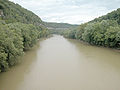
Kentucky River in the Bluegrass region
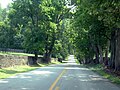
Narrow country roads bounded by stone and wood plank fences are a fixture in the Bluegrass region.


References[]
- ^ Hammon, Neal O. "Early Kentucky Land Records, 1773–1780". Genealogy Trails History Group. Genealogy Trails. Retrieved 24 March 2019.
- ^ Dag Ryen (letter to the editor) (June 3, 1993). "What Makes Kentucky's Bluegrass Blue". The New York Times. p. 22. Retrieved 2018-06-15.
- ^ "Bluegrass region - region, Kentucky, United States". Encyclopedia Britannica.
- ^ "Home". www.firstvineyard.net.
- ^ Bill Monroe, considered the "Father of bluegrass music", named his band the Blue Grass Boys after his home state. He was from Rosine in western Kentucky. The music takes its name from that band, and hence from the state's nickname rather than the region.
Further reading[]
- Klotter, James C. and Daniel Rowland, eds. Bluegrass Renaissance: The History and Culture of Central Kentucky, 1792–1852 (Lexington: University Press of Kentucky, 2012),
- Raitz, Karl, and Nancy O'Malley, "The Nineteenth-Century Evolution of Local-Scale Roads in Kentucky's Bluegrass," Geographical Review, 94 (October 2005), 415–39
External links[]
| Wikivoyage has a travel guide for Bluegrass Region. |
- Bluegrass Heritage Museum
- Local Directory for Frankfort, the State Capital
- Slayman, Andrew (Spring 2007). "A Race Against Time for Kentucky's Bluegrass Country". World Monuments Fund. Archived from the original on 2009-10-13. Retrieved 2009-11-07.
- Raitz, Carl; Nancy O'Malley (January 2007). "Local-scale turnpike roads in nineteenth-century Kentucky". Journal of Historical Geography. 33 (1): 1–23. doi:10.1016/j.jhg.2005.12.003.

- Regions of Kentucky