Mercer County, Kentucky
Mercer County | |
|---|---|
U.S. county | |
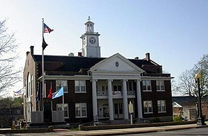 Mercer County Courthouse in Harrodsburg | |
 Location within the U.S. state of Kentucky | |
 Kentucky's location within the U.S. | |
| Coordinates: 37°48′N 84°53′W / 37.8°N 84.88°W | |
| Country | |
| State | |
| Founded | 1785 |
| Named for | Hugh Mercer |
| Seat | Harrodsburg |
| Largest city | Harrodsburg |
| Area | |
| • Total | 253 sq mi (660 km2) |
| • Land | 249 sq mi (640 km2) |
| • Water | 4.5 sq mi (12 km2) 1.8%% |
| Population | |
| • Estimate (2018) | 21,774 |
| • Density | 86/sq mi (33/km2) |
| Time zone | UTC−5 (Eastern) |
| • Summer (DST) | UTC−4 (EDT) |
| Congressional district | 2nd |
| Website | www |

Mercer County is a county located in the U.S. Commonwealth of Kentucky. As of the 2010 census, the population was 21,331.[1] Its county seat is Harrodsburg.[2] The county was formed from Lincoln County, Virginia in 1785[3] and is named for Revolutionary War General Hugh Mercer, who was killed at the Battle of Princeton in 1777.[4]
It is a prohibition or dry county, though the city of Harrodsburg allow the sale of alcohol by the drink and in package stores. Beer and wine are also available for sale in grocery stores in the city of Harrodsburg. Pleasant Hill allows the sale of alcohol by the drink. In Kentucky this is referred to as being a "moist" county; wet counties sell package liquor, wine and beer, dry counties sell no alcoholic beverages (legally), while "moist" counties serve only by the drink, primarily in restaurants. Boyle County (Danville) immediately to the south along US Hwy 127, is wet, with two large liquor outlet stores, plus several smaller, privately owned ones.
History[]
Harrodsburg was the first city formally chartered in Kentucky County, the Virginia district that later became the 15th state. It was originally the county seat of Lincoln County when it was formed in 1780, but it became the seat of Mercer County when it was created.
Pleasant Hill, also known as Shakertown, is the site of a former Shaker community, active especially in the years before the American Civil War. It is a National Historic Landmark District, consisting of more than 30 historic buildings. The district also includes acres of farm and parkland.
During the Civil War, the county was divided in sentiment. Union control permitted the organization 2 Union regiments, the 19th Regiment Kentucky Volunteer Infantry and the 11th Regiment Kentucky Volunteer Cavalry. However, many county men also served in the Confederate Army. The 19th Kentucky Infantry (Union)was organized at Camp Harwood for a three-year enlistment commencing January 2, 1862, commanded Col. William J. Landram. Companies A, C, D, and F of the 11th Kentucky Cavalry (Union) were organized at Harrodsburg in July 1862. The remainder of the regiment was organized in Louisville, Kentucky, and mustered in for three years on September 26, 1862, under the Colonel Alexander W. Holeman. Following the Battle of Perryville, much of Harrodsburg and surrounding towns were converted into makeshift hospitals; 1600 sick and wounded Confederate soldiers were captured during a raid in Harrodsburg by the 9th Kentucky Cavalry on October 10, 1862. The city then remained under martial law for the remainder of the war.[citation needed]
The Louisville Southern Railroad reached Harrodsburg in 1888. Louisville Southern Railway's construction commenced in 1884 and ran from Louisville through Shelbyville and Lawrenceburg to Harrodsburg, which was reached in 1888. The rail yard and station were located at the corner of Office Street and Merimon Avenue. A spur was later constructed from the station to Burgin, where the Louisville Southern joined the Cincinnati Southern's Cincinnati, New Orleans and Texas Pacific Railway CNO&TP mainline which runs through the eastern part of the country from High Bridge of Kentucky to Burgin to Danville was opened in 1877. Now all run and operated by Norfolk Southern Railway.
Company D of the 192nd Tank Battalion, which took part in the World War II Battle of Bataan was from Harrodsburg.[5]
Geography[]
According to the U.S. Census Bureau, the county has a total area of 253 square miles (660 km2), of which 249 square miles (640 km2) is land and 4.5 square miles (12 km2) (1.8%) is water.[6]
Adjacent counties[]
- Anderson County (north)
- Woodford County (northeast)
- Jessamine County (east)
- Garrard County (southeast)
- Boyle County (south)
- Washington County (west)
Demographics[]
| Historical population | |||
|---|---|---|---|
| Census | Pop. | %± | |
| 1790 | 7,091 | — | |
| 1800 | 9,646 | 36.0% | |
| 1810 | 12,630 | 30.9% | |
| 1820 | 15,587 | 23.4% | |
| 1830 | 17,694 | 13.5% | |
| 1840 | 18,720 | 5.8% | |
| 1850 | 14,067 | −24.9% | |
| 1860 | 13,701 | −2.6% | |
| 1870 | 13,144 | −4.1% | |
| 1880 | 14,142 | 7.6% | |
| 1890 | 15,034 | 6.3% | |
| 1900 | 14,426 | −4.0% | |
| 1910 | 14,063 | −2.5% | |
| 1920 | 14,795 | 5.2% | |
| 1930 | 14,471 | −2.2% | |
| 1940 | 14,629 | 1.1% | |
| 1950 | 14,643 | 0.1% | |
| 1960 | 14,596 | −0.3% | |
| 1970 | 15,960 | 9.3% | |
| 1980 | 19,011 | 19.1% | |
| 1990 | 19,148 | 0.7% | |
| 2000 | 20,817 | 8.7% | |
| 2010 | 21,331 | 2.5% | |
| 2018 (est.) | 21,774 | [7] | 2.1% |
| U.S. Decennial Census[8] 1790-1960[9] 1900-1990[10] 1990-2000[11] 2010-2013[1] | |||
As of the census[12] of 2000, there were 20,817 people, 8,423 households, and 6,039 families residing in the county. The population density was 83 per square mile (32/km2). There were 9,289 housing units at an average density of 37 per square mile (14/km2). The racial makeup of the county was 94.00% White, 3.69% Black or African American, 0.21% Native American, 0.47% Asian, 0.03% Pacific Islander, 0.63% from other races, and 0.96% from two or more races. 1.27% of the population were Hispanics or Latinos of any race.
There were 8,423 households, out of which 31.80% had children under the age of 18 living with them, 57.80% were married couples living together, 10.40% had a female householder with no husband present, and 28.30% were non-families. 25.10% of all households were made up of individuals, and 11.60% had someone living alone who was 65 years of age or older. The average household size was 2.45 and the average family size was 2.93.
By age, 24.40% of the population was under 18, 7.40% from 18 to 24, 29.10% from 25 to 44, 24.50% from 45 to 64, and 14.60% were 65 or older. The median age was 38 years. For every 100 females there were 94.00 males. For every 100 females age 18 and over, there were 89.70 males.
The median income for a household in the county was US$35,555, and the median income for a family was $43,121. Males had a median income of $33,657 versus $22,418 for females. The per capita income for the county was $17,972. About 10.00% of families and 12.90% of the population were below the poverty line, including 17.40% of those under age 18 and 12.00% of those age 65 or over.
Notable people[]
- Ralph G. Anderson, founder Belcan Corporation, philanthropist
- Jacqueline Coleman, 58th Lieutenant Governor of Kentucky (2019- )
- Maria Thompson Daviess (1872–1924), author
- Jason Dunn, National Football League player
- David Winfield Huddleston, Christian author and minister
- Rachel Jackson, wife of President Andrew Jackson
- Frances Wisebart Jacobs, philanthropist
- Ann O'Delia Diss Debar, late 19th and early 20th century medium and criminal.
- Dennis Johnson, National Football League player
- William Logan, politician
- Beriah Magoffin, Governor of Kentucky (1859 − 1862) and namesake of Magoffin County, Kentucky
- William Sullivan, politician and lawyer
- John Burton Thompson, politician
- Al Wilson, actor and stunt pilot
- Craig Yeast, National Football League player
Law and government[]
|
|
|
Local attractions[]
- Old Fort Harrod State Park, features a reconstruction of Fort Harrod, the first permanent settlement in the state of Kentucky.
- Shaker Village of Pleasant Hill, a living history museum.
- Herrington Lake
Communities[]
Cities[]
Census-designated place[]
Unincorporated communities[]
Ghost town[]
- Hilltop
Notable residents[]
- John Adair, member of the United States House of Representatives and United States Senate, also governor of Kentucky[14]
See also[]
References[]
- ^ Jump up to: a b "State & County QuickFacts". United States Census Bureau. Archived from the original on June 25, 2011. Retrieved March 6, 2014.
- ^ "Find a County". National Association of Counties. Retrieved 2011-06-07.
- ^ Collins, Lewis (1882). Collins' Historical Sketches of Kentucky: History of Kentucky, Volume 2. Collins & Company. p. 26.
- ^ The Register of the Kentucky State Historical Society, Volume 1. Kentucky State Historical Society. 1903. pp. 36.
- ^ Life Magazine 1942
- ^ "2010 Census Gazetteer Files". United States Census Bureau. August 22, 2012. Archived from the original on August 12, 2014. Retrieved August 18, 2014.
- ^ "Population and Housing Unit Estimates". Retrieved July 29, 2019.
- ^ "U.S. Decennial Census". United States Census Bureau. Retrieved August 18, 2014.
- ^ "Historical Census Browser". University of Virginia Library. Retrieved August 18, 2014.
- ^ "Population of Counties by Decennial Census: 1900 to 1990". United States Census Bureau. Retrieved August 18, 2014.
- ^ "Census 2000 PHC-T-4. Ranking Tables for Counties: 1990 and 2000" (PDF). United States Census Bureau. Retrieved August 18, 2014.
- ^ "U.S. Census website". United States Census Bureau. Retrieved 2008-01-31.
- ^ Leip, David. "Dave Leip's Atlas of U.S. Presidential Elections". uselectionatlas.org. Retrieved 2018-07-04.
- ^ Who Was Who in America, Historical Volume, 1607-1896. Marquis Who's Who. 1963.
External links[]
| show Municipalities and communities of Mercer County, Kentucky, United States |
|---|


Coordinates: 37°48′N 84°53′W / 37.80°N 84.88°W
| show Authority control |
|---|
- Kentucky counties
- Mercer County, Kentucky
- 1785 establishments in Virginia
- Populated places established in 1785
- Former counties of Virginia