Argentera
Argentera
L'Argentiera | |
|---|---|
| Comune di Argentera | |
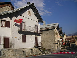 View of Bersezio | |
 Coat of arms | |
show Location of Argentera | |
 Argentera Location of Argentera in Italy | |
| Coordinates: 44°24′N 6°56′E / 44.400°N 6.933°E | |
| Country | Italy |
| Region | Piedmont |
| Province | Cuneo (CN) |
| Frazioni | Bersezio (municipal seat), Ferrere, Le Grange and Severagno (ruinied boroughs), Villaggio Primavera, Prinardo, Serre |
| Government | |
| • Mayor | Monica Ciaburro |
| Area | |
| • Total | 77.7 km2 (30.0 sq mi) |
| Elevation | 1,684 m (5,525 ft) |
| Population | |
| • Total | 78 |
| • Density | 1.0/km2 (2.6/sq mi) |
| Demonym(s) | Argentesi or Argenters |
| Time zone | UTC+1 (CET) |
| • Summer (DST) | UTC+2 (CEST) |
| Postal code | 12010 |
| Dialing code | 0171 |


Argentera is a comune (municipality) in the Province of Cuneo in the Italian region Piedmont, located about 100 kilometres (62 mi) southwest of Turin and about 60 kilometres (37 mi) west of Cuneo, on the border with France. It consists of a series of sparse hamlets in the upper Valle Stura di Demonte. The municipal seat is in Bersezio, on the road to the Maddalena Pass.
Argentera borders the following municipalities: Acceglio, Canosio, Larche (France), Pietraporzio, and Saint-Etienne-de-Tinée (France). Its territory includes peaks such as the at an elevation of 2,860 metres (9,380 ft) above sea level, Enciastraia at 2,955 metres (9,695 ft) and the Rocca dei Tre Vescovi at 2,867 metres (9,406 ft).
References[]
- ^ "Superficie di Comuni Province e Regioni italiane al 9 ottobre 2011". Istat. Retrieved 16 March 2019.
- ^ "Popolazione Residente al 1° Gennaio 2018". Istat. Retrieved 16 March 2019.
- ^ All demographics and other statistics: Italian statistical institute Istat.
| Authority control |
|
|---|
This article on a location in the Province of Cuneo is a stub. You can help Wikipedia by . |
- Municipalities of the Province of Cuneo
- Cities and towns in Piedmont
- Province of Cuneo geography stubs