Arly
| Arly | |
|---|---|
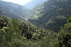 The Arly Gorge near Cohennoz | |
 | |
| Location | |
| Country | France |
| Physical characteristics | |
| Source | |
| • location | Mégève |
| Mouth | Isère |
• location | Albertville |
• coordinates | 45°39′42″N 6°23′25″E / 45.6617°N 6.3904°ECoordinates: 45°39′42″N 6°23′25″E / 45.6617°N 6.3904°E |
| Length | 32 km (20 mi) |
| Basin features | |
| Progression | Isère→ Rhône→ Mediterranean Sea |

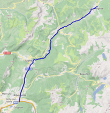
The Arly (French pronunciation: [aʁli]) is a 32.1 km long river in the departments of Savoie and Haute-Savoie, France.[1] It is a tributary of the Isère, which it joins at Albertville.
Towns crossed by the river[]
- Megève
- Praz-sur-Arly
- Flumet
- Saint-Nicolas-la-Chapelle
- Crest-Voland
- Héry-sur-Ugine
- Cohennoz
- Ugine
- Marthod
- Albertville
Tributaries[]
See also[]
- Rivers of France
References[]
External links[]
| hide Authority control | |
|---|---|
| General |
|
| National libraries | |
This Auvergne-Rhône-Alpes geographical article is a stub. You can help Wikipedia by . |
Categories:
- Tributaries of the Isère
- Rivers of France
- Rivers of Savoie
- Rivers of Haute-Savoie
- Rivers of Auvergne-Rhône-Alpes
- Rivers of the Alps
- Auvergne-Rhône-Alpes geography stubs
- France river stubs