Armenochori, Greece
Armenochori, Armenovo
Αρμενοχώρι, Арменово | |
|---|---|
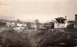 Armenochori (c. 1915-1916) | |
 Armenochori, Armenovo | |
| Coordinates: 40°48′N 21°28′E / 40.800°N 21.467°ECoordinates: 40°48′N 21°28′E / 40.800°N 21.467°E | |
| Country | Greece |
| Administrative region | West Macedonia |
| Regional unit | Florina |
| Municipality | Florina |
| Municipal unit | Florina |
| Community | |
| • Population | 986 (2011) |
| Time zone | UTC+2 (EET) |
| • Summer (DST) | UTC+3 (EEST) |
| Postal code | 531 00 |
| Vehicle registration | ΡΑ |

Armenochori (Greek: Αρμενοχώρι), (Macedonian: Арменово, Armenovo), (Bulgarian: Арменово or Арменохор, Armenovo or Armenohor) is a village in the Florina regional unit, northern Greece. It is situated along the Greek National Road 2, 4 km northeast of Florina.

In 1990 the Armenochori Cultural Society started collecting objects from folk culture which led to the creation of the Folklore Collection. The collection is housed in the old primary school of Armenochori in the centre of the village. Displayed in the three rooms of the building are objects from folk culture, which come exclusively from the families of Armenochori. There are men's and women's traditional costumes, domestic utensils, various metal, earthenware or wooden objects used in the home, objects relating to cottage industry, the most notable among them being a nineteenth-century loom, farming tools and tools of a number of other occupations, as well as the old pulpit from the village church.[2]
History[]
In 1845 the Russian slavist Victor Grigorovich recorded Arminor as mainly Bulgarian village.[3] According to the statistics of Geographers Dimitri Mishev and D. M. Brancoff, the town had a total Christian population of 776 in 1905, consisting of 424 Patriarchist Bulgarians (Grecomans) and 352 Exarchist Bulgarians.[4] It also had 2 schools, 1 Bulgarian and 1 Greek.[4]
References[]
- ^ a b "Απογραφή Πληθυσμού - Κατοικιών 2011. ΜΟΝΙΜΟΣ Πληθυσμός" (in Greek). Hellenic Statistical Authority.
- ^ Museums of Macedonia web site
- ^ Григорович, В. Очеркъ путешествiя по Европейской Турцiи, Москва, 1877 "...населено преимущественно Болгарами с примесью Валахов и Турков. Поименую села их: Владово, Острово, Кочено, Кадрево, Гугово, Русилово, Дружко, Ослово, Пачетин, Ниссие, Чегано, Крмско, Учин, Грамматиново, Ракита, Каменек, Баината, Орево, Жерве, Петерско у озера, Рошава, Пътеле, Суровичево, Гулинци, [93] Любетино, Зеленич, Палиора, Дебрец, Невеска и Судир (в обоих сел. Влахи), Вербини, еще Вербини, Црево, Баньци, Забердин, Вуштарни, Крушораде, Ситина, Совиче, Добровина, Бачь, Куйнавите, Ромалия, Саново село, Секулево, Кальник, Клештина, Арминор, Кодорево, Клобучище, Арменско, Неволино, Лежини, Кучковини, Пешошница, Вартолом, Лесковец..."
- ^ a b Dimitri Mishev and D. M. Brancoff, La Macédoine et sa Population Chrétienne, p. 176
- Folk museums in Western Macedonia
- Populated places in Florina (regional unit)