Proti, Florina

Proti (Greek: Πρώτη, Bulgarian/Macedonian Slavic: Кладошница, Kladošnica or Кабасница, Kabasnica) is a small village in the Florina regional unit of Macedonia, northern Greece, located approximately 5 kilometres northwest from the city of Florina, to which it belongs administratively.
History[]
The village first appears in two chysobulls of the Serbian Tsar Stefan Dušan preserved in the archives of Treskavec monastery near Prilep. The documents, dated to 1343-44 and 1344–45, mention the village under its Aromanian name Klbasnicu in connection with a transhumant "route of the Vlachs," a toponym (vlaški pat) preserved today for a footpath following the crest of a hill to the west of the village. An Ottoman defter of 1481 records eighty households in the village.[1]
In the book “Ethnographie des Vilayets d'Adrianople, de Monastir et de Salonique”, published in Constantinople in 1878, that reflects the statistics of the male population in 1873, Kladochnitza was noted as a village with 40 households and 110 male Bulgarian inhabitants.[2] According to the statistics of Geographers Dimitri Mishev and D. M. Brancoff, the village had a total Christian population of 520 in 1905, all Patriarchist Bulgarians (Grecomans).[3] It also had 1 Greek school.[3]
At one time a flourishing community of 500 people whose primary occupation was wheat farming, Proti today is an agricultural hamlet with 120 residents (2011 census).[4]
There are a number of public buildings in the hamlet. The school, though unused, is in good condition. The church is impeccably maintained. In the rear of the church is the graveyard with many stones that are centuries old.
Proti was ravaged during World War II. Many residents left in the 1950s and 1960s in search of a better life and went to the U.S., Canada, and Australia.
Demographics[]
|
Notes[]
- ^ Kravari, Vassiliki (1989). Villes et villages de Macédoine occidentale. Réalités byzantines (in French). 2. Paris: Editions P. Lethielleux. p. 280. ISBN 2-283-60452-4.
- ^ Македония и Одринско. Статистика на населението от 1873 г. Македонски научен институт, 1995. стр. 84-85. (in Bulgarian)
- ^ Jump up to: a b Dimitri Mishev and D. M. Brancoff, La Macédoine et sa Population Chrétienne, p. 176
- ^ Απογραφή Πληθυσμού - Κατοικιών 2011. ΜΟΝΙΜΟΣ Πληθυσμός (in Greek). Hellenic Statistical Authority.

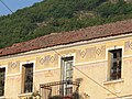
A house
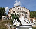
The cemetery

The church
The schoolhouse


- Populated places in Florina (regional unit)