Arrondissement of Torcy
Torcy | |
|---|---|
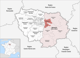 Location within the region Île-de-France | |
| Country | France |
| Region | Île-de-France |
| Department | Seine-et-Marne |
| No. of communes | 142 |
| Subprefecture | Torcy |
| Area | 354.8 km2 (137.0 sq mi) |
| Population (Jan. 2018)[1] | 456,847 |
| • Density | 1,288/km2 (3,340/sq mi) |
| INSEE code | 775 |
The arrondissement of Torcy is an arrondissement of France in the Seine-et-Marne department in the Île-de-France region. It has 43 communes.[2] Its population is 432,090 (2016), and its area is 354.8 km2 (137.0 sq mi).[3]
Composition[]
The communes of the arrondissement of Torcy, and their INSEE codes, are:[2]
- Bailly-Romainvilliers (77018)
- Brie-Comte-Robert (77053)
- Brou-sur-Chantereine (77055)
- Bussy-Saint-Georges (77058)
- Bussy-Saint-Martin (77059)
- Carnetin (77062)
- Chalifert (77075)
- Champs-sur-Marne (77083)
- Chanteloup-en-Brie (77085)
- Chelles (77108)
- Chessy (77111)
- Chevry-Cossigny (77114)
- Collégien (77121)
- Conches-sur-Gondoire (77124)
- Coupvray (77132)
- Courtry (77139)
- Croissy-Beaubourg (77146)
- Dampmart (77155)
- Émerainville (77169)
- Férolles-Attilly (77180)
- Gouvernes (77209)
- Gretz-Armainvilliers (77215)
- Guermantes (77221)
- Jablines (77234)
- Jossigny (77237)
- Lagny-sur-Marne (77243)
- Lesches (77248)
- Lésigny (77249)
- Lognes (77258)
- Magny-le-Hongre (77268)
- Montévrain (77307)
- Noisiel (77337)
- Ozoir-la-Ferrière (77350)
- Pomponne (77372)
- Pontault-Combault (77373)
- Roissy-en-Brie (77390)
- Saint-Thibault-des-Vignes (77438)
- Serris (77449)
- Servon (77450)
- Thorigny-sur-Marne (77464)
- Torcy (77468)
- Tournan-en-Brie (77470)
- Vaires-sur-Marne (77479)
- Villeneuve-le-Comte (77508)
- Villeneuve-Saint-Denis (77510)
History[]
In February 1993 the arrondissement of Noisiel was created from parts of the arrondissements of Melun (cantons of Roissy-en-Brie and Pontault-Combault) and Meaux (cantons of Claye-Souilly, Lagny-sur-Marne, Torcy, Vaires-sur-Marne, Champs-sur-Marne and Noisiel.[4][5] Torcy replaced Noisiel as subprefecture in April 1994.[4][6] At the January 2017 reorganisation of the arrondissements of Seine-et-Marne, it received seven communes from the arrondissement of Melun, and it lost five communes to the arrondissement of Meaux and two communes to the arrondissement of Provins.[7] In August 2018 the communes Villeneuve-le-Comte and Villeneuve-Saint-Denis passed from the arrondissement of Provins to the arrondissement of Torcy.[8][9]
As a result of the reorganisation of the cantons of France which came into effect in 2015, the borders of the cantons are no longer related to the borders of the arrondissements. The cantons of the arrondissement of Torcy were, as of January 2015:[10]
References[]
- ^ "Téléchargement du fichier d'ensemble des populations légales en 2018". The National Institute of Statistics and Economic Studies. 28 December 2020.
- ^ a b "Arrondissement de Torcy (775)". INSEE. Retrieved 2019-10-03.
- ^ "Comparateur de territoire, géographie au 01/01/2019". INSEE. Retrieved 2019-10-03.
- ^ a b Historique de Seine-et-Marne
- ^ Décret n° 93-260 du 26 février 1993 portant modification de cantons et création de l'arrondissement de Noisiel (Seine-et-Marne)
- ^ Décret no 94-336 du 28 avril 1994 portant transfert du chef-lieu de l'arrondissement de Noisiel à Torcy (Seine-et-Marne)
- ^ "Arrêté préfectoral, 30 December 2016" (PDF). pp. 11–23. Retrieved 2019-10-27.
- ^ Commune de Villeneuve-le-Comte (77508), INSEE
- ^ Commune de Villeneuve-Saint-Denis (77510), INSEE
- ^ "Populations légales 2012" (PDF). INSEE. December 2014. Retrieved 2019-10-07.

- Arrondissements of Seine-et-Marne