Île-de-France
Île-de-France | |
|---|---|
 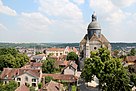   Clockwise from top: western Paris and La Défense in the distance, the Viaduc of Saint-Mammès, the Palace of Versailles, and the UNESCO World Heritage Site of Provins | |
 Coat of arms Brandmark | |
 | |
| Country | France |
| Prefecture | Paris |
| Departments | |
| Government | |
| • President of the Regional Council | Valérie Pécresse (SL) |
| Area | |
| • Total | 12,012 km2 (4,638 sq mi) |
| Area rank | 13th |
| Population (Jan. 2020)(INSEE) | |
| • Total | 12,278,210 |
| • Density | 1,000/km2 (2,600/sq mi) |
| Demonym(s) | French: Francilien |
| Time zone | UTC+01:00 (CET) |
| • Summer (DST) | UTC+02:00 (CEST) |
| ISO 3166 code | FR-IDF |
| GRP[1] | Ranked 1st |
| –Total | €738 billion ($882 billion) in 2019 |
| –Per capita | €60,100 ($71,900) |
| NUTS Region | FR1 |
| Website | www |
The Île-de-France (/ˌiːl də ˈfrɒ̃s/, French: [il də fʁɑ̃s] (![]() listen); literally "Isle of France") is the most populous of the eighteen regions of France. Centred on the capital Paris, it is located in the north-central part of the country and often called the Région Parisienne ("Paris Region"). Île-de-France is densely populated and retains a prime economic position on the national stage: though it covers only 12,012 square kilometres (4,638 square miles), about 2% of metropolitan French territory, its estimated 2020 population of 12,278,210 was nearly one-fifth of the national total; its economy accounts for nearly one-third of the French gross domestic product.[2]
listen); literally "Isle of France") is the most populous of the eighteen regions of France. Centred on the capital Paris, it is located in the north-central part of the country and often called the Région Parisienne ("Paris Region"). Île-de-France is densely populated and retains a prime economic position on the national stage: though it covers only 12,012 square kilometres (4,638 square miles), about 2% of metropolitan French territory, its estimated 2020 population of 12,278,210 was nearly one-fifth of the national total; its economy accounts for nearly one-third of the French gross domestic product.[2]
The region is made up of eight administrative departments: Paris, Essonne, Hauts-de-Seine, Seine-Saint-Denis, Seine-et-Marne, Val-de-Marne, Val-d'Oise and Yvelines. It was created as the "District of the Paris Region" in 1961. In 1976, its status was aligned with the French administrative regions that were created in 1972, it was renamed after the historic province of Île-de-France. Residents are sometimes referred to as Franciliens, an administrative word created in the 1980s. The GDP of the region in 2018 was €734 billion (or US$882 billion at market exchange rates). It has the highest per capita GDP of any French region and the third highest of any region in the European Union. The Île-de-France region alone accounts for 5% of the European Union's GDP, for only about 2.7% of the Union's population. In 2018, nearly all of the twenty-eight French companies listed in the Fortune Global 500 were based in the Île-de-France.[3][failed verification]
Beyond the city limits of Paris, the region has many other important historic sites, including the palaces of Versailles and Fontainebleau, as well as the most-visited tourist attraction in France, Disneyland Paris. Though it is the richest French region, a significant number of residents live in poverty: the official poverty rate in the Île-de-France was 15.9% in 2015. The region has witnessed increasing income inequality in recent decades and rising housing prices have pushed the less affluent outside Paris.[4]
Etymology[]
Although the modern name Île-de-France literally means "Island of France", its etymology is in fact unclear. The "island" may refer to the land between the rivers Oise, Marne and Seine, or it may also have been a reference to the Île de la Cité, where the French royal palace and cathedral were located.
History[]
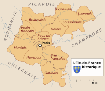
Historic province of Île-de-France before the French Revolution

The modern départements covered by the historical Île-de-France
Modern region of Île-de-France and départements


The Île-de-France was inhabited by the Parisii, a sub-tribe of the Celtic Senones, from around the middle of the 3rd-century BC.[5][6] One of the area's major north–south trade routes crossed the Seine on the île de la Cité; this meeting place of land and water trade routes gradually became an important trading centre.[7] The Parisii traded with many river towns (some as far away as the Iberian Peninsula) and minted their own coins for that purpose.[8]
The Romans conquered the area in 52 BC and began their settlement on Paris's Left Bank.[9] It became a prosperous city with a forum, baths, temples, theatres, and an amphitheatre.[10] Christianity was introduced in the middle of the 3rd century AD by Saint Denis, the first Bishop of Paris. According to legend, when Denis refused to renounce his faith before Roman authorities he was beheaded on the hill that became known as Mons Martyrum (Latin "Hill of Martyrs"), later "Montmartre". The legend further states that Denis walked headless from this hill to the north of the city. The place where he finally fell and was buried became an important religious shrine, the Basilica of Saint-Denis.[11]
Clovis the Frank, the first king of the Merovingian dynasty, made the city his capital from 508. As the Frankish domination of Gaul began, there was a gradual immigration by the Franks to Paris and the Parisian Francien dialects were born. Fortification of the Île de la Cité failed to avert sacking by Vikings in 845, but Paris's strategic importance—with its bridges preventing ships from passing—was established by successful defence in the Siege of Paris (885–86). In 987, Hugh Capet, Count of Paris (comte de Paris) and Duke of the Franks (duc des Francs), was elected King of the Franks (roi des Francs). Under the rule of the Capetian kings, Paris gradually became the largest and most prosperous city in France.[11]
The Kings of France enjoyed getting away from Paris and hunting in the game-filled forests of the region. They built palatial hunting lodges, most notably Palace of Fontainebleau and the Palace of Versailles. From the time of Louis XIV until the French Revolution, Versailles was the official residence of the Kings and the seat of the French government. Île-de-France became the term used for the territory of Paris and the surrounding province, which was administered directly by the King.
During the French Revolution, the royal provinces were abolished and divided into departments, and the city and region were governed directly by the national government. In the period after World War II, as Paris faced a major housing shortage, hundreds of massive apartment blocks for low-income residents were built around the edges of Paris. In the 1950s and the 1960s, thousands of immigrants settled in the communes bordering the city. In 1959, under President Charles De Gaulle, a new region was created out of six departments, which corresponded approximately with the historic region, with the name District de la région de Paris ("District of the Paris Region"). On 6 May 1976, as part of the process of regionalisation, the district was reconstituted with increased administrative and political powers and renamed the Île-de-France region.
Geography[]
Île-de-France is in the north of France, neighboring Hauts-de-France to the north, Grand Est to the east, Bourgogne-Franche-Comté to the southeast, Centre-Val-de-Loire to the southwest, and Normandy to the west.

View of the forest of Fontainebleau in Seine-et-Marne

The Seine in Paris
Vineyard in Luzarches, Val-d'Oise
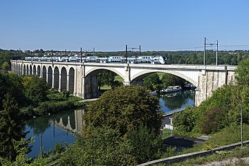
Transilien Line R train between Veneux-les-Sablons and Saint-Mammès


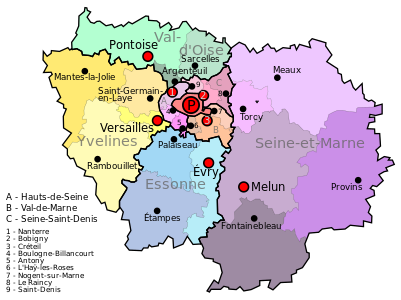
Departments[]
Île-de-France has a land area of 12,011 km2 (4,637 sq mi). It is composed of eight departments centred on its innermost department and capital, Paris. Around the department and municipality of Paris, urbanisation fills a first concentric ring of three departments commonly known as the petite couronne ("small ring"); it extends into a second outer ring of four departments known as the grande couronne ("large ring"). The former department of Seine, abolished in 1968, included the city proper and parts of the petite couronne.
The petite couronne consists of the departments of Hauts-de-Seine, Seine-Saint-Denis and Val-de-Marne; the grande couronne consists of those of Seine-et-Marne, Yvelines, Essonne and Val-d'Oise. Politically, the region is divided into 8 departments, 25 arrondissements, 155 cantons and 1,276 communes, out of the total of 35,416 in metropolitan France.[12]
Topography[]
The outer parts of the Île-de-France remain largely rural. Agriculture land, forest and natural spaces occupy 78.9 percent of the region, Twenty-eight percent of the region's land is in urban usage, while the remaining 24 percent is rivers, forests, woods, and ponds.[13]
The River Seine flows through the middle of the region, and the region is crisscrossed by its tributaries and sub-tributaries, including the Rivers Marne, Oise and Epte. The River Eure does not cross the region but receives water from several rivers in the Île-de-France, including the Drouette and the Vesgre. The major rivers are navigable, and, because of the modest variations of altitude in the region (between 10 and 200 meters), they have a tendency to meander and curve. They also create many lakes and ponds, some of which have been transformed into recreation areas. (Moisson-Mousseaux, Cergy-Neuville, Villeneuve-Saint-Georges, etc.).
Economy[]

Headquarters of Total in La Défense
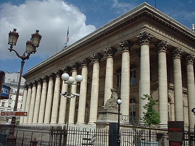
The historic Bourse de Paris, or Paris stock market, now called Euronext Paris

Headquarters of Société Générale in La Défense


The Paris Region is France's most important center of economic activity. In 2016, the region had a gross domestic product (GDP) of €681 billion (US$850 billion). The region accounts for nearly 30 percent of the French Gross Domestic Product (GDP). < All but one of the twenty-nine French companies listed in the Fortune Global 500 have their headquarters in Paris.[14]
The regional economy has gradually shifted toward high-value-added service industries (finance, IT services, etc.) and high-tech manufacturing (electronics, optics, aerospace, etc.).[15] In 2014 industry represented just under five percent of active enterprises in the region, and 10.2 percent of salaried workers. Commerce and services account for 84 percent of the business establishments in the region, and have 83.3 percent of the salaried employees.[16]
Financial services and insurance are important sectors of the regional economy; the major French banks and insurance companies, including BNP Paribas, Société générale, and Crédit agricole, all have their headquarters in the region, The region also hosts the headquarters of the top French telecom companies and utilities, including Orange S.A., Veolia and EDF, The French stock market, the Bourse de Paris, now known as Euronext Paris, occupies a historical building in the center of Paris, is in ranked fourth among global stock markets, after New York, Tokyo and London.,
Other major sectors of the regional economy include energy companies (Orano, Engie, Électricité de France. and Total S.A., the top French company in the Fortune Global 500, The two major French automobile manufacturers Renault at Flins-sur-Seine, and Groupe PSA at Poissy, do much of their assembly work outside of France, but still have research centers and large plants in the region. The leading French and European aerospace and defense companies, including (Airbus] industries; Thales Group, Dassault Aviation, Safran Aircraft Engines, the European Space Agency, Alcatel-Lucent, and Arianespace have a large presence in the region. The automotive industry: Renault Groupe PSA [17]
The Energy sector is also well established in the region. The nuclear power industry, with its major firm Orano, has its headquarters in Île-de-France, as does he main French oil company Total S.A., the top French company in the Fortune Global 500, and the main electric utility, Électricité de France. The energy firm Engie also has its main offices in the region at La Défense.
All the major French banks, including BNP Paribas, Société générale, and Crédit agricole, have their main offices in the Paris Region, as well as the major French telecom and utility companies, including Orange S.A., Veolia, and EDF. The French stock market, the Bourse de Paris, now known as Euronext Paris, occupies a historical building in the center of Paris and is ranked fourth among global stock markets, after New York, Tokyo, and London.[18]
Employment[]
In 2018 just 7.2 percent of employees in the Region were engaged in industry; 62.3 percent were engaged in commerce and market services; 25.5 percent in non-market services, including government, health and education; 4.8 percent in construction; and 0.2 percent in agriculture.[19]
The largest non-government employers in the Region as of the end of 2015 were the airline Air France (40,657); the SNCF (French Railways): 31,955; the telecom firm Orange S.A. (31,497); the bank Société Générale (27,361); the automotive firm Groupe PSA (19,648); EDF (Electricité de France); 18,199; and Renault (18,136).[20] While the Petite Couronne, or departments closest to Paris, previously employed the most industrial workers, the largest number is now in the Grande Couronne, the outer departments.[21]
The unemployment rate in the region stood at 8.6% at the end of 2016. It varied within the region from 7.8 percent in the city of Paris, to a high of 12.7 percent in Seine-Saint-Denis; 10 percent in Val-d'Oise; to regional lows of 7.5 percent in Hauts-de-Seine; 7.4 percent in Yvelines 7.7 percent in Essonne; and 7.9 percent in Seine et Marne, and 8.8 percent in Val de Marne.[22]
Agriculture[]
In 2018 48 percent of the land of the Île-de-France was devoted to agriculture; 569,000 hectares were cultivated. The most important crops are grains (66 percent), followed by beets (7 percent), largely for industrial use, and grass for grazing. In 2014, 9,495 hectares were devoted to bio-agriculture. However, the number of persons employed in agriculture in the region dropped thirty-three percent between 2000 and 2015, to just 8,460 persons in 2015.[23]
Tourism[]
The Île-de-France is one of the world's top tourist destinations, with a record 23.6 million hotel arrivals in 2017, and an estimated 50 million visitors in all types of accommodation. The largest number of visitors came from the United States, followed by England, Germany and China.[24] [25][26] It was ranked as the third most visited travel destination in the world in 2017, after Bangkok and London.[27] The top tourist attraction in the region in 2017 was Disneyland Paris, which received 14.8 million visitors in 2017, followed by the Cathedral of Notre-Dame (est. 12 million) and the Basilica of Sacre-Coeur at Montmartre (est. 11.1 million visitors).[28]

Notre-Dame Cathedral (12 million visitors in 2017)
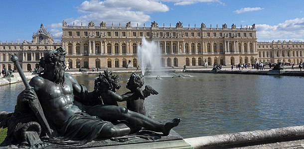
Palace of Versailles (7.7 million visitors in 2017)
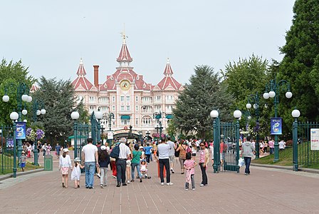
Disneyland Paris (14.8 million visitors in 2017)
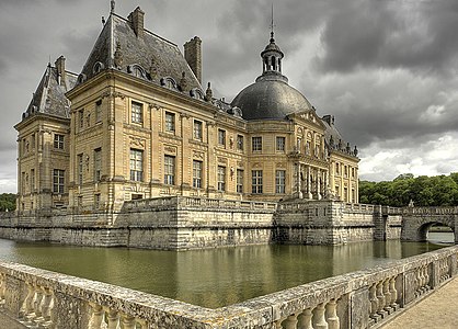
Château of Vaux le Vicomte


Notable historic monuments in the Region outside of Paris include the Palace of Versailles (7,700,000 visitors), the Palace of Fontainebleau (500,000 visitors), the chateau of Vaux-le-Vicomte (300,000 visitors), and the Château de Malmaison, Napoleon's former country house; and the Basilica of Saint-Denis, where the Kings of France were interred before the French Revolution.[29]
Regional government and politics[]

The Regional Council is the legislative body of the region. Its seat is in Paris, at 33 rue Barbet-de-Jouy in the 7th arrondissement. On 15 December 2015, a list of candidates of the Union of the Right, a coalition of centrist and right-wing parties, led by Valérie Pécresse, narrowly won the regional election, defeating the Union of the Left, a coalition of socialists and ecologists. The socialists had governed the region for the preceding seventeen years.
Since 2016 the regional council has 121 members from the Union of the Right, 66 from the Union of the Left and 22 from the far-right National Front.[30]
Holders of the executive office[]
- Delegates General for the District of the Paris Region
- 1961–1969: Paul Delouvrier (civil servant) – Very influential term. Responsible for the creation of the RER express subway network in the Île-de-France and beyond.
- 1969–1975: Maurice Doublet (civil servant)
- 1975–1976: Lucien Lanier (civil servant)
- Presidents of the Regional Council of Île-de-France
- 1976–1988: Michel Giraud (RPR politician) – (1st time)
- 1988–1992: Pierre-Charles Krieg (RPR politician)
- 1992–1998: Michel Giraud (RPR politician) – (2nd time)
- 1998-2015: Jean-Paul Huchon (PS)
- 2016- Valérie Pécresse (Union of the Centre-Right)
Demographics[]
Population density[]
As of 1 January 2017, the population density of the region was 1010.9 inhabitants per square kilometer. The densest area is Paris itself, with 21,066 inhabitants per square kilometer. The least-densely populated département is Seine-et-Marne with 239 residents per square kilometer.[31]
Wealth and poverty[]
As of 2015 according to the official government statistics agency INSEE, 15.9 percent of residents of the region had an income below the poverty level; for residents of the city of Paris, this proportion was 16.2 percent. Poverty was highest in the departments of Seine-Saint-Denis (29 percent), Val-d'Oise (17.1 percent), and Val-de-Marne (16.8 percent). It was lowest in Yvelines (9.7 percent); Seine-et-Marne (11.8 percent), Essone (12.9 percent), and Hauts-de-Seine (12.4 percent). The department of Hauts-de-Seine is the wealthiest in France in terms of per capita GDP.[32]
Immigration[]
| 2015 Census Paris Region[33][34] | |||
|---|---|---|---|
| Country/territory of birth | Population | ||
| 9,165,570 | |||
| 310,019 | |||
| 243,490 | |||
| 241,403 | |||
| 117,161 | |||
| 80,062 | |||
| 77,300 | |||
| 69,835 | |||
| 67,540 | |||
| 60,438 | |||
| 56,692 | |||
| 55,022 | |||
| 52,758 | |||
| 49,124 | |||
| 47,091 | |||
| 47,058 | |||
| |||
In 2013, 2,206,000 residents of the Île-de-France were immigrants, born outside of France. This amounts to 18.5% of the population of the region, twice the national average. Four out of ten immigrants living in France reside in the region. The immigrant population of the Île-de-France has a higher proportion of non-Europeans, as well as a higher proportion of immigrants with an advanced level of education, than the rest of France. The population of immigrants is more widely distributed throughout the region than it was in the early 2000s, though the concentrations remain high in certain areas, particularly Paris and the department of Seine-Saint-Denis. The proportion of residents born outside of Metropolitan France has dropped since the 1999 (19.7%) and the 2010 censuses (23%).[35]
Petite Couronne[]
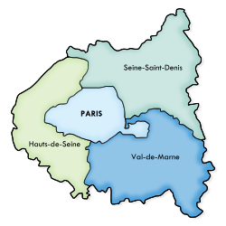

The Petite Couronne[36] (literally "Little Crown" or inner ring) is formed by the three departments bordering Paris, forming a geographical crown around it. These departments, until 1968 part of the disbanded Seine department, are Hauts-de-Seine, Seine-Saint-Denis and Val-de-Marne. The most populated towns of the Petite Couronne are Boulogne-Billancourt, Montreuil, Saint-Denis, Nanterre and Créteil.
The Métropole du Grand Paris is an administrative structure that comprises Paris and the three departments of the Petite Couronne, plus seven additional communes in the Grande Couronne.
The table below shows some statistical information about the area including Paris:
| Department | Area (km2) | Population (2011)[37] | Municipalities |
|---|---|---|---|
| Paris (75) | 105.4
|
2 249 975
|
1 (Paris)
|
| Hauts-de-Seine (92) | 176
|
1 581 628
|
36 (list)
|
| Seine-Saint-Denis (93) | 236
|
1 529 928
|
40 (list)
|
| Val-de-Marne (94) | 245
|
1 333 702
|
47 (list)
|
| Petite Couronne | 657
|
4 445 258
|
123
|
| Paris + Petite Couronne | 762.4
|
6 695 233
|
124
|
Grande Couronne[]
The Grande Couronne[38] (Large Crown, i.e. outer ring) includes the outer four departments of Île-de-France not bordering Paris. They are Seine-et-Marne (77), Yvelines (78), Essonne (91) and Val-d'Oise (95). The latter three departments formed the Seine-et-Oise department until this was disbanded in 1968. The city of Versailles is part of this area.
Historical population[]
|
|
| ||||||||||||||||||||||||||||||||||||||||||||||||||||||||||||||||||||||||||||||||||||||||||||||||||||||||||||||||||||||||
| Census returns until 2017; official January estimates from INSEE from 2018 on. | ||||||||||||||||||||||||||||||||||||||||||||||||||||||||||||||||||||||||||||||||||||||||||||||||||||||||||||||||||||||||||
International relations[]
Twin regions[]
Île-de-France is twinned with:
 Comunidad de Madrid in Spain (since 2000)
 Yerevan in Armenia (since 2011)[39]
 Hanoi in Vietnam (since 2013)[40]
See also[]
References[]
- ^ "Database - Regions - Eurostat".
- ^ "Ile-de-France- Portrait of the Region- Key figures (in French)". Regional Council of the Ile-de-France. Retrieved 24 November 2018.
- ^ "Ile-de-France- Portrait of the Region- Key figures (in French)". Regional Council of the Ile-de-France. Retrieved 24 November 2018.
- ^ "En quinze ans, Paris s'est enrichi, mais sa région s'est appauvrie, révèle une étude". France Info (in French). 3 June 2019.
- ^ Arbois de Jubainville & Dottin 1889, p. 132.
- ^ Cunliffe 2004, p. 201.
- ^ Lawrence & Gondrand 2010, p. 25.
- ^ Schmidt 2009, pp. 65–70.
- ^ Schmidt 2009, pp. 88–104.
- ^ Schmidt 2009, pp. 154–167.
- ^ Jump up to: a b Schmidt 2009, pp. 210–11.
- ^ "Ile-de-France- Portrait of the Region- Key figures (in French)". Regional Council of the Ile-de-France. Retrieved 24 November 2018.
- ^ "Ile-de-France- Portrait of the Region- Key figures (in French)". Regional Council of the Ile-de-France. Retrieved 24 November 2018.
- ^ "Ile-de-France- Portrait of the Region- Key figures (in French)". Regional Council of the Ile-de-France. Retrieved 24 November 2018.
- ^ "L'Industrie en Île-de-France, Principaux Indicateurs Régionaux" (PDF). INSEE. Retrieved 24 November 2014.
- ^ "Leading industrial enterprises in Ile-de-France".
- ^ "Key figures on economy of Ile-de-France (2018) (in French)" (PDF).
- ^ "Key figures on economy of Ile-de-France (2018) (in French)" (PDF).
- ^ "Key Figures 2018: Employment statistics from Government of the Ile-de-France, retrieved December 1, 2018" (PDF).
- ^ "Chamber of Commerce and Industry of Ile-de-France, retrieved 12-2-2018)" (PDF).
- ^ "Key Figures 2018: Employment statistics from Government of the Ile-de-France, retrieved December 1, 2018" (PDF).
- ^ "INSEE report, Unemployment in Ile-de-France, by department, end of 2016".
- ^ "Ile-de-France- une region plus agricole que on ne le croit". Regional Council of the Ile-de-France. Retrieved 24 November 2018.
- ^ "Tourism statistics, Paris Region tourism office".
- ^ Key Figures: Paris Convention and Visitors Bureau Key
- ^ Vers une fréquentation touristique record à Paris en 2017 on Les Echos
- ^ Mastercard Global Destinations Index 2017
- ^ Key Figures 2017: Paris Convention and Visitors Bureau
- ^ Annual Report of the Regional Committee on Tourism of the Ile-de-France Region, cited in La Croix, 22 February 2018.
- ^ Île-de-France Region official site. "Results of 2015 Regional Elections". Retrieved 16 December 2015.
- ^ "Site of Ile-de-France Region" (PDF). Retrieved 29 November 2018.
- ^ "Level of poverty according to age and fiscal reference in 2015" (in French). INSEE. Retrieved 29 November 2018.
- ^ INSEE. "Individus localisés à la région en 2015 - Recensement de la population - Fichiers détail" (in French). Retrieved 8 September 2019.
- ^ INSEE. "IMG1B - Population immigrée par sexe, âge et pays de naissance en 2015 - Région d'Île-de-France (11)" (in French). Retrieved 8 September 2019.
- ^ "Fichier Données harmonisées des recensements de la population de 1968 à 2010" (in French). INSEE. Retrieved 25 November 2013.
- ^ (in French) CIG "Petite Couronne" website (Centre Interdépartemental de Gestion)
- ^ INSEE. "Estimation de population au 1er janvier, par département, sexe et grande classe d'âge – Année 2011" (in French). Retrieved 20 February 2014.
- ^ (in French) CIG "Grande Couronne" website (Centre Interdépartemental de Gestion)
- ^ "Yerevan - Partner Cities". Yerevan Municipality Official Website. Technology Management Center of Yerevan. Archived from the original on 5 November 2013. Retrieved 4 November 2013.
- ^ "Hanoi strengthens ties with Ile-de-France". Voice of Vietnam. Retrieved 4 May 2018.
Bibliography[]
- Fierro, Alfred (1996). Histoire et dictionnaire de Paris. Lafont. ISBN 978-0-7859-9300-1.
- Schmidt, Joël (2009). Lutèce: Paris, des origines à Clovis. Perrin. ISBN 978-2-262-03015-5.
External links[]
| Wikimedia Commons has media related to Île-de-France. |
| Wikivoyage has a travel guide for Île-de-France. |
- Paris Region Map, the interactive economic map of Paris Region
- Regional Council of Île-de-France (in French)
- Île-de-France at Curlie

| show Authority control |
|---|

- Île-de-France
- Regions of France
- NUTS 1 statistical regions of the European Union
- NUTS 2 statistical regions of the European Union
- Former provinces of France
- History of Île-de-France
- History of Centre-Val de Loire
- History of Hauts-de-France
- History of Grand Est
- History of Bourgogne-Franche-Comté
- History of Aisne
- History of Ardennes (department)
- History of Essonne
- History of Eure-et-Loir
- History of Hauts-de-Seine
- History of Loiret
- History of Oise
- History of Paris
- History of Seine-et-Marne
- History of Seine-Saint-Denis
- History of Somme (department)
- History of Val-de-Marne
- History of Val-d'Oise
- History of Yonne
- History of Yvelines
- France