Bourgogne-Franche-Comté
Bourgogne-Franche-Comté
Borgogne-Franche-Comtât (Arpitan) | |
|---|---|
 Vineyards in Volnay | |
 Flag  Coat of arms  Brandmark | |
 | |
| Country | |
| Regional council seat | Besançon |
| Prefecture | Dijon |
| Departments | |
| Government | |
| • President of the Regional Council | Marie-Guite Dufay (PS) |
| • Prefect | Bernard Schmeltz |
| Area | |
| • Total | 47,783 km2 (18,449 sq mi) |
| Area rank | 6th |
| Population (2017) | |
| • Total | 2,811,423 |
| • Density | 59/km2 (150/sq mi) |
| Time zone | UTC+01:00 (CET) |
| • Summer (DST) | UTC+02:00 (CEST) |
| ISO 3166 code | FR-BFC |
| GDP | Ranked 11 of 18 |
| Total | 76.6 € billion (EUR€ bn) |
| Per capita | 24,200 € (EUR€) |
| Website | www |
Bourgogne-Franche-Comté (French: [buʁɡɔɲ fʁɑ̃ʃ kɔ̃te] (![]() listen); lit. 'Burgundy-Free County', sometimes abbreviated BFC; Arpitan: Borgogne-Franche-Comtât) is a region in Eastern France created by the 2014 territorial reform of French regions, from a merger of Burgundy and Franche-Comté. The new region came into existence on 1 January 2016, after the regional elections of December 2015, electing 100 members to the regional council of Bourgogne-Franche-Comté.[1]
listen); lit. 'Burgundy-Free County', sometimes abbreviated BFC; Arpitan: Borgogne-Franche-Comtât) is a region in Eastern France created by the 2014 territorial reform of French regions, from a merger of Burgundy and Franche-Comté. The new region came into existence on 1 January 2016, after the regional elections of December 2015, electing 100 members to the regional council of Bourgogne-Franche-Comté.[1]
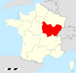
The region covers an area of 47,783 km2 (18,449 sq mi) and eight departments; it had a population of 2,811,423 in 2017.[2] Its prefecture and largest city is Dijon, although the regional council sits in Besançon, making Bourgogne-Franche-Comté one of two regions in France with Normandy in which the prefect does not sit in the same city as the regional council.
Toponymy[]
The text of the territorial reform law gives interim names for most of the merged regions, combining the names of their constituent regions separated by hyphens. Permanent names would be proposed by the new regional councils and confirmed by the Conseil d'État by 1 October 2016.[3] Hence the interim name of the new administrative region is composed of the names of former administrative regions of Burgundy (Bourgogne) and Franche-Comté. The region chose to retain its interim name as its permanent name, a decision made official by the Conseil d'État on 28 September 2016.[4]
The merger represents a historic reunification of the Duchy of Burgundy (Duché de Bourgogne) and the Free County of Burgundy (Franche Comté de Bourgogne) that were created by the partition of the Kingdom of Burgundy in the 843 Treaty of Verdun.
History[]
Middle Ages[]
The territory that is now Burgundy and Franche-Comté was already united under the Kingdom of Burgundy (from the 5th to the 8th century). It was divided into two parts: the Duchy of Burgundy (now Burgundy) of France, and the County of Burgundy (now Franche-Comté) of the Holy Roman Empire. The County was reintegrated as a free province within the Kingdom of France in the 17th century, separately from the Duchy which remained a vassal province of the Kingdom of France. These two former provinces were abolished during the French Revolution.

The Kingdom of Burgundy during the 5th century.

Duchy and County of Burgundy during the 14th century.


Modern times[]

Most of the area making up the region of Bourgogne-Franche-Comté used to belong to the former provinces of Burgundy and Franche-Comté, but it also includes a significant part of the former provinces of Nivernais (now Nièvre), Champagne (now the northern part of Yonne), Orléanais (now the southwestern part of Yonne), the Territoire de Belfort (the region of Alsace that remained French territory after 1871) and a small portion of Île-de-France (now the northwestern part of Yonne).
From 1941 to 1944 the regional prefecture of Vichy reunited Burgundy and Franche-Comté, as did the of Dijon from 1948 to 1964. During the formation of the regions of France, Burgundy and Franche-Comté once again became two separate regions, first as public establishments in 1972, then as territorial collectivities in 1982.
On 14 April 2014, François Patriat and Marie-Guite Dufay (the presidents of Burgundy and Franche-Comté, respectively) announced in a press conference the desire for the reunification of the two regions, further to the declarations of Prime Minister Manuel Valls, who proposed a simplification of the administrative divisions of France. On 2 June 2014 a map presented by President François Hollande showed the two regions as one. These two regions were the only ones to have voluntarily discussed a merger, and their alliance was the only one not needing revision by the National Assembly or the Senate.
Acte III de la décentralisation officially adopted the merger of the two regions on 17 December 2014. It became effective on 1 January 2016.
Geography[]
The region borders Grand Est to the north, Île-de-France to the northwest, Centre-Val de Loire to the west, Auvergne-Rhône-Alpes to the south and Switzerland (the cantons of Vaud, Neuchâtel and Jura) to the east.
The distances from Besançon, where the regional council sits, to other cities, are:[5] Paris, the national capital, 410 km (255 mi); Bordeaux, 729 km (453 mi); Toulouse, 762 km (473 mi); Marseille, 538 km (334 mi); Lyon, 227 km (141 mi); Montpellier, 523 km (325 mi); Nice, 694 km (431 mi).
Departments[]
Bourgogne-Franche-Comté comprises eight departments: Côte-d'Or, Doubs, Jura, Nièvre, Haute-Saône, Saône-et-Loire, Yonne, Territoire de Belfort.
Major communities[]

The largest communes are (population as of 2017):[6]
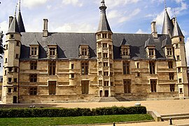
- Dijon (156,920; headquarters regional prefecture)
- Besançon (115,934; headquarters regional council)
- Belfort (47,656)
- Chalon-sur-Saône (45,096)
- Auxerre (34,634)
- Mâcon (33,638)
- Nevers (32,990)
Economy[]
The gross domestic product (GDP) of the region was 75.6 billion euros in 2018, accounting for 3.2% of French economic output. GDP per capita adjusted for purchasing power was 24,200 euros or 80% of the EU27 average in the same year. The GDP per employee was 96% of the EU average.[7]
Gallery[]

The old city of Besançon in the oxbow of the Doubs River

Verrerie Street, Dijon
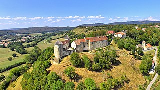
Belvoir Castle
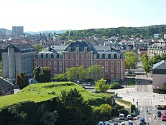
Departmental Council building, Belfort

The Yonne River at Auxerre

The Armançon in Semur-en-Auxois


See also[]
References[]
- ^ "La carte à 13 régions définitivement adoptée" [The 13-region map finally adopted]. Le Monde (in French). Agence France-Presse. 17 December 2014. Retrieved 13 January 2015.
- ^ "Comparateur de territoire: Région de Bourgogne-Franche-Comté (27)". Insee. Retrieved 11 September 2020.
- ^ Loi n° 2015-29 du 16 janvier 2015 relative à la délimitation des régions, aux élections régionales et départementales et modifiant le calendrier électoral (in French)
- ^ Décret n° 2016-1268 du 28 septembre 2016 portant fixation du nom et du chef-lieu de la région Bourgogne-Franche-Comté (in French)
- ^ "Ville de Besançon". Annuaire-Mairie.fr (in French). Retrieved 13 June 2018.
- ^ Téléchargement du fichier d'ensemble des populations légales en 2017, INSEE
- ^ "Regional GDP per capita ranged from 30% to 263% of the EU average in 2018". Eurostat.
External links[]
| Wikivoyage has a travel guide for Bourgogne-Franche-Comté. |
| show Authority control |
|---|
- Bourgogne-Franche-Comté
- Regions of France
- 2016 establishments in France
- States and territories established in 2016