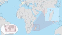
Mayotte
Department of Mayotte
Département de Mayotte | |
|---|---|
 Aerial view of Dzaoudzi and Pamanzi | |
 Coat of arms | |
 | |
| Coordinates: 12°50′35″S 45°08′18″E / 12.84306°S 45.13833°ECoordinates: 12°50′35″S 45°08′18″E / 12.84306°S 45.13833°E | |
| Country | |
| Prefecture | Mamoudzou |
| Departments | 1 |
| Government | |
| • President of the Departmental Council | Soibahadine Ibrahim Ramadani (LR) |
| Area | |
| • Total | 374 km2 (144 sq mi) |
| Area rank | 18th region |
| Population (Jan. 2021)[1] | |
| • Total | 288,926 |
| • Density | 770/km2 (2,000/sq mi) |
| Demonym(s) | Mahoran Maorais |
| Time zone | UTC+03:00 (EAT) |
| ISO 3166 code | |
| GDP (2019)[2] | Ranked 18th among France's 18 regions |
| Total | €2.64 billion (US$2.96 bn) |
| Per capita | €9,600 (US$10,800) |
| NUTS Region | FRA |
| Website | Prefecture Departmental Council |

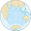
Mayotte (French: Mayotte, pronounced [majɔt]; Shimaore: Maore, IPA: [maˈore]; Malagasy: Maiôty) is an overseas department/region and single territorial collectivity of France officially named the Department of Mayotte (French: Département de Mayotte).[3] is located in the northern Mozambique Channel in the Indian Ocean off the coast of Southeast Africa, between northwestern Madagascar and northeastern Mozambique. Mayotte consists of a main island, Grande-Terre (or Maore), a smaller island, Petite-Terre (or Pamanzi), and several islets around these two. Mayotte is the most prosperous territory in the Mozambique Channel, making it a major destination for illegal immigration.
Mayotte's land area is 374 square kilometres (144 sq mi) and, with its 288,926 people according to January 2021 official estimates,[1] is very densely populated at 773 inhabitants per km2 (2,001 per sq mi). The biggest city and prefecture is Mamoudzou on Grande-Terre. The Dzaoudzi–Pamandzi International Airport is located on the neighbouring island of Petite-Terre. The territory is also known as Maore, the native name of its main island.
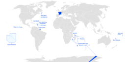
Mayotte is one of the overseas departments of France as well as one of the 18 regions of France, with the same status as the departments of Metropolitan France. It is an outermost region of the European Union and, as an overseas department of France, part of the eurozone.
French is spoken as a second language, while 63% of the population 14 years[4] and older reported in 2007 that they could speak French. The predominant native language of Mayotte is Shimaore.
The next most common native language is Kibushi, a Malagasy language, of which there are two varieties, Kibushi Kisakalava, most closely related to the Sakalava dialect of Malagasy, and Kibushi Kiantalaotra. Both have been influenced by Shimaore. The vast majority of the population is Muslim.
The island was populated from neighbouring East Africa with later arrival of Arabs, who brought Islam. A sultanate was established in 1500. In the 19th century, Mayotte was conquered by Andriantsoly, former king of Iboina on Madagascar.
Mayotte broke away from the Comoros and remained with France[5] after the Comoros declared its independence following in the 1974 referendum.[6] Mayotte became an overseas department on 31 March 2011 and became an outermost region of the European Union on 1 January 2014, following a March 2009 referendum with an overwhelming result in favour of the department status.
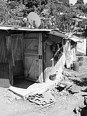
The new department is facing enormous problems and challenges. According to an INSEE report published in 2018, 84% of the population live under the poverty line (established at €959 per month and per household), compared to 16% in metropolitan France, 40% of dwellings are corrugated sheet metal shacks, 29% of households have no running water, and 34% of the inhabitants between the age of 15 and 64 do not have a job.[7] In 2019, with an annual population growth of 3.8%, half the population was less than 17 years old. In addition, as a result of massive illegal immigration from neighboring islands, 48% of the population are foreign nationals.[8]
It is the only French Department and the Region in France without a Arrondissement.
Geography[]
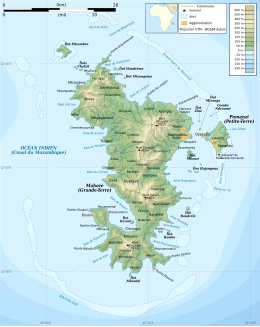
The term Mayotte (or Maore) may refer to all of the department's islands, of which the largest is known as Maore (French: Grande-Terre) and includes Maore's surrounding islands, most notably Pamanzi (French: Petite-Terre), or only to the largest island. The name is believed to come from Mawuti, contraction of the Arabic جزيرة الموت Jazīrat al-Mawt – meaning "island of death" (maybe due to the dangerous reefs circling the island) and corrupted to Mayotta in Portuguese, later turned into French. However, the local name is Mahore, and the Arabic etymology is doubtful.
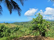
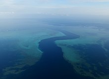
The main island, Grande-Terre (or Maore), geologically the oldest of the Comoro Islands, is 39 kilometres (24 mi) long and 22 kilometres (14 mi) wide, and its highest point is Mount Benara, at 660 metres (2,165 ft) above sea level. Because of the volcanic rock, the soil is relatively rich in some areas. A coral reef encircling much of the island ensures protection for ships and a habitat for fish. Dzaoudzi was the capital of Mayotte (and earlier the capital of all the colonial Comoros) until 1977, when the capital was relocated to Mamoudzou on the main island of Grande-Terre. It is situated on Petite-Terre (or Pamanzi), which at 10 square kilometres (4 sq mi) is the largest of several islets adjacent to Maore. The area of the lagoon behind the reef is approximately 1,500 square kilometres (580 sq mi), reaching a maximum depth of about 80m. It is described as "the largest barrier-reef-lagoon complex within the southwestern Indian Ocean".[9]
Topography[]
Mayotte is the oldest of the four large islands of the Comoros archipelago,[10] a chain of land emerging from a crescent-shaped submarine relief at the entrance to the Mozambique Channel. Located 295 km west of Madagascar and 67 km southeast of Anjouan, sometimes visible at sunset in the shade, it is composed of several islands and islets covered with lush vegetation. The two largest islands are Grande-Terre and Petite-Terre, backed by a coral reef.
This 160 km long coral reef surrounds a 1,100 km2 lagoon, one of the largest and deepest in the world.[10] Part of the barrier reef features a double barrier that is rare on the planet. It protects almost all of Mayotte from ocean currents and waves, except for a dozen passes, including one in the east called the "S-pass". The lagoon, which averages 5 to 10 km wide, is up to 100 meters deep.
It is dotted with about a hundred coral islets, such as Mtsamboro. This reef serves as a refuge for boats and oceanic fauna. The volcanic activity that created the islands makes the soil particularly fertile.
The total area of Mayotte is about 374 km2, which makes it by far the smallest French overseas department (after Martinique, which is three times larger at 1,128 km2). However, this area is difficult to assess accurately, given the number of small uninhabited islets, some of which are completely underwater at high tide, but may reveal significant areas at low tide. The main islands are
- Grande-Terre, 363 km2, is 39 km long and 22 km wide. Its highest points are: Mount Bénara or Mavingoni (660 m), Mount Choungui (594 m), Mount Mtsapéré (572 m) and Mount Combani (477 m). It is home to Mamoudzou, which is the economic capital of Mayotte and houses the departmental council and the prefecture;
- Petite-Terre (or Pamanzi Island), with Dzaoudzi (official capital of Mayotte) and Pamandzi (where the airport is located). It is 11 km2;
- Mtsamboro is the third largest island (2 km2). It is permanently inhabited, mainly by fishermen;
- Mbouzi islet (84 hectares or 0.84 km2) is classified as a nature reserve;
- Bandrélé islet is the fifth largest island;
- Sable Blanc islet is located near the Saziley Marine Park (marine protected area).
Environment[]
Geology[]

Mayotte is a primarily volcanic island rising steeply from the bed of the ocean to a height of 660 metres (2,170 ft) on Mont Bénara (Open Street Map gives this as 661 metres (2,169 ft)).
Two volcanic centres are reported, a southern one (Pic Chongui, 594 metres (1,949 ft)) with a breached crater to the NW, and a northern centre (Mont M'Tsapéré, 572 metres (1,877 ft)) with a breached crater to the south-east. Mont Bénara is on the curving ridge between these two peaks, approximately at the contact point of the two structures. Volcanic activity started about 7.7 million years ago in the south, ceasing about 2.7 million years ago. In the north, activity started about 4.7 million years ago and lasted until about 1.4 million years ago. Both centres had several phases of activity.[11] The most recent age reported for an ash band is 7000 year BP.[9]
Earthquake swarm[]
The November 11, 2018, seismic event occurred about 15 miles (24 km) off the coast of Mayotte. It was recorded by seismograms in many places, including Kenya, Chile, New Zealand, Canada, and Hawaii located almost 11,000 miles (18,000 km) away.[12] The seismic waves lasted for more than 20 minutes, but despite this, no one felt it.[13][12]
Subsequently, the earthquake swarm has been linked to a newly discovered undersea volcano located 50 km away from Mayotte at a depth of 3500m.[14]
Marine environment[]

Mayotte is surrounded by a typical tropical coral reef. It consists in a large outer barrier reef, enclosing one of the world's largest and deepest lagoons, followed by a fringing reef, interrupted by many mangroves. All Mayotte waters are ruled by a National marine Park, and many places are natural reserves.
The outer coral reef is 195 km long, housing 1,500 km2 of lagoon, including 7.3 km2 of mangrove. There are at least 250 different species of coral, 760 tropical fish species, and the National Natural Heritage Inventory (INPN) has no fewer than 3,616 marine species, but this is probably a far cry from the actual count. As this region of the world is still poorly inventoried by scientists, the waters of Mayotte continue to harbour many species unknown to science, and allow important scientific discoveries each year.[15]
Terrestrial environment[]

Mayotte has a great diversity in its plant life: more than 1,300 species are recorded, half of them being endemic, making this island one of the richest in plant diversity in the world compared to its size.[16] 15% of the island is classified as natural reserve; however, the primal forest now covers barely 5% of the island due to illegal deforestation.
Just like many volcanic islands, Mayotte shelters quite a limited mammal biodiversity, the only native species being flying foxes (Pteropus seychellensis comorensis). However, there are 18 species of reptiles, 23 of terrestrial mollusks, 116 butterflies, 38 dragonflies, 50 grasshoppers, 150 beetles.[16]
History[]
In 1500, the Maore sultanate was established on the island. In 1503, Mayotte was observed and named (firstly Espirito Santo) by Portuguese explorers, but not colonized. The island has known several eras of wealth (especially during the 11th century at Acoua or between 9th and 12th centuries at Dembéni), being an important part of the Swahili coast culture. However, its sister island Anjouan was preferred by international traders due to its better suitability to large boats, and, for a long time, Mayotte remained poorly developed compared to the three other Comoros islands, often being targeted by pirates and Malagasy or Comorian raids.

In 1832, Mayotte was conquered by Andriantsoly, former king of Iboina on Madagascar; in 1833, it was conquered by the neighbouring sultanate of Mwali (Mohéli island in French). On 19 November 1835, Mayotte was again conquered by the Ndzuwani Sultanate (Anjouan sultanate in French); a governor was installed with the unusual Islamic style of Qadi (from the Arabic قاض which means judge). However, in 1836 it regained its independence under a last local Sultan. Andriantsoly won again the island in 1836, but his depopulated and unfortified island was in a weak position towards the sultans of Comoros, Malagasy kings and pirates. Looking for the help of a powerful ally, he began to negotiate with the French, installed in the nearby Malagasy island of Nosy Bé in 1840.
Mayotte was purchased by France in 1841, and integrated to the Crown. This also entailed the end of the slavery regime which had dominated the island for centuries: the slaves were set free and most of the masters, ruined, had to leave the island.
Mayotte therefore became a French island, but it remained an island emptied of its inhabitants by decades of wars, as well as by the exodus of former elites and part of their slaves: most of the cities were abandoned, and nature regained its rights over the old plantations. The French administration therefore tried to repopulate the island, recalling first of all the Mayotte exiles or refugees in the region (Comoros, Madagascar), proposing the former exiled masters return in exchange for compensation, then by inviting wealthy Anjouan families to come and set up trade. France launched some first major works, such as the realization in 1848 of the Boulevard des Crabes connecting the rock of Dzaoudzi to Pamandzi and the rest of Petite-Terre.
In the wake of the West Indies and Réunion, the French government planned to make Mayotte a sugar island: despite the steep slopes, large plantations were developed, 17 sugar factories were built and hundreds of foreign workers (mainly African, in particular Mozambic Makwas) hired from 1851 onwards. However, production remained mediocre, and the sugar crisis of 1883–1885 quickly led to the end of this crop in Mayotte (which had just reached its peak of production), leaving only a few factory ruins, some of which are still visible now. The last sugar plant to be closed was Dzoumogné in 1955: the best preserved, and now heritage, is Soulou, in the west of the island.
At the Berlin conference in 1885, France took control over the whole Comoros archipelago, which was actually already ruled by French traders; the colony took the name of "Mayotte and dependencies".
In 1898, two cyclones razed the island to the ground, and a smallpox epidemic decimated the survivors. Mayotte had to start from the beginning once again, and the French government had to repopulate the island with workers from Mozambique, Comoros and Madagascar. The sugar industry was abandoned, replaced by vanilla, coffee, copra, sisal, then fragrant plants such as vetiver, citronelle, sandalwood and especially ylang-ylang, which later became one of the symbols of the island.

Mayotte was the only island in the archipelago that voted in referenda in 1974 and 1976 to retain its link with France and forgo independence (with 63.8% and 99.4% of votes respectively). The United Nations' constant policy regarding decolonisation has been that independence must be effected in the framework of the colonial borders and for that reason it has not recognized the validity of that referendum; during the late 20th century, over twenty UN resolutions have condemned France's annexation of Mayotte, while the independent Comoros have never ceased to claim the island.[17] A draft 1976 United Nations Security Council resolution recognizing Comorian sovereignty over Mayotte, supported by 11 of the 15 members of the council, was vetoed by France.[18] It was the only time, as of 2020, that France cast a lone veto in the council.[19] The United Nations General Assembly adopted a series of resolutions on the issues, under the title "Question of the Comorian Island of Mayotte" up to 1995. Since 1995, the subject of Mayotte has not been discussed by the General Assembly, and all the following referenda over Mayotte independence have shown a strong will of Mayotte people to remain French, self-determination being the main value of the UN.
Mayotte became an overseas department of France in March 2011 in consequence of a 29 March 2009 referendum.[20] The outcome was a 95.5 percent vote in favour of changing the island's status from a French "overseas community" to become France's 101st département.[21] Its non-official traditional Islamic law, applied in some aspects of the day-to-day life, will be gradually abolished and replaced by the uniform French civil code.[22] Additionally, French social welfare and taxes apply in Mayotte, though some of each will be brought in gradually.[23] Comoros continues to claim the island, while criticising the French military base there.[24][needs update]
In 2018, the department experienced civil unrest over migration from the Comoros.[25]
Politics[]

The politics of Mayotte takes place in a framework of a parliamentary representative democratic government and of a multi-party system, whereby the President of the Departmental Council is the head of the local assembly. Executive power is exercised by the French government.
Mayotte also sends two deputies to the French National Assembly and two senators to the French Senate. The deputies represent Mayotte's 1st constituency and Mayotte's 2nd constituency.
Unlike the other overseas regions and departments of France, Mayotte possesses a single local assembly, officially called the "departmental council" (conseil départemental), which acts both as a regional and departmental council.
The situation of Mayotte proved to be awkward for France: while a significant majority of the local population did not want to join the Comoros in becoming independent of France, some post-colonial leftist governments voiced criticism of Mayotte's ongoing ties to France.[citation needed] Furthermore, the peculiar local administration of Mayotte, largely ruled by customary Muslim law, would be difficult to integrate into the legal structures of France, not to mention the costs of bringing the standards of living to levels close to those of Metropolitan France. For these reasons, the laws passed by the national parliament had to state specifically that they applied to Mayotte for them to be applicable on Mayotte.
The status of Mayotte was changed in 2001 towards one very close to the status of the departments of France, with the particular designation of departmental collectivity. This change was approved by 73% of voters in a referendum. After the constitutional reform of 2003 it became an overseas collectivity while retaining the title "departmental collectivity" of Mayotte.
Mayotte became an overseas department of France (département d'outre-mer, DOM) on 31 March 2011 following the result of the March 2009 Mahoran status referendum, which was overwhelmingly approved by around 95% of voters.[27][28] Becoming an overseas department will mean it will adopt the same legal and social system as used in the rest of France. This will require abandoning some customary laws, adopting the standard French civil code, and reforming the judiciary, educational, social and fiscal systems, and will take place over a period of about 20 years.[29]
Despite its domestic constitutional evolution from the status of an overseas collectivity to that of an overseas department, effectively becoming a full constituent territory within the French Republic, with regards to the European Union, Mayotte remained an 'overseas country and territory' (OCT) in association with the Union (as per Article 355(2) TFEU) and not a constituent territory of the European Union in the same way as the other four overseas departments. However following a directive of the European Council in December 2013, Mayotte became an outermost region of the European Union on 1 January 2014.[30] This successful agreement between the 27 member states follows a petition made by the French government for Mayotte to become an integral territory of the European Union nonetheless benefiting from the derogation clause applicable in existing outermost regions, namely Article 349 TFEU, as favoured in a June 2012 European Commission opinion on Mayotte's European constitutional status.[31]
Administrative divisions[]
Mayotte is divided into 17 communes. There are also 13 cantons (not shown here). There are no arrondissements.
| Number on Map | Name | Area (km2) | Population | Individual map | Labelled map |
|---|---|---|---|---|---|
| 1 | Dzaoudzi | 6.66 | 17,831 | 
|

|
| 2 | Pamandzi | 4.29 | 11,442 | 
| |
| 3 | Mamoudzou | 41.94 | 71,437 | 
| |
| 4 | Dembeni | 38.8 | 15,848 | 
| |
| 5 | Bandrélé | 36.46 | 10,282 | 
| |
| 6 | Kani-Kéli | 20.51 | 5,507 | 
| |
| 7 | Bouéni | 14.06 | 6,189 | 
| |
| 8 | Chirongui | 28.31 | 8,920 | 
| |
| 9 | Sada | 11.16 | 11,156 | 
| |
| 10 | Ouangani | 19.05 | 10,203 | 
| |
| 11 | Chiconi | 8.29 | 8,295 | 
| |
| 12 | Tsingoni | 34.76 | 13,934 | 
| |
| 13 | M'Tsangamouji | 21.84 | 6,432 | 
| |
| 14 | Acoua | 12.62 | 5,192 | 
| |
| 15 | Mtsamboro | 13.71 | 7,705 | 
| |
| 16 | Bandraboua | 32.37 | 13,989 | 
| |
| 17 | Koungou | 28.41 | 32,156 | 
|
Transport[]
- Waterways
- Ferry between Dzaoudzi and Mamoudzou.
- Highways:
- Total: 93 kilometres (58 mi)
- Paved: 72 kilometres (45 mi)
- Unpaved: 21 kilometres (13 mi)
- Total: 93 kilometres (58 mi)
- Ports and harbours:
- Dzaoudzi
- "Longoni" (Koungou)
- Airport: Dzaoudzi Pamandzi International Airport
- With paved runways: 1 (2002)
Economy[]
The official currency in Mayotte is the euro.[32]
In 2019, the GDP of Mayotte at market exchange rates was €2.64 billion (US$2.96 bn).[2] In that same year the GDP per capita of Mayotte at market exchange rates, not at PPP, was €9,600 (US$10,800),[2][1] which was 8 times larger than the GDP per capita of the Comoros that year, but only 42% of the GDP per capita of Réunion and 26% of the GDP per capita of Metropolitan France. Living standards are therefore lower than in metropolitan France. At the 2017 census, 10% of dwellings in Mayotte had no electricity, 29% of dwellings had no running water inside the dwelling, and 54% of dwellings had no toilets inside the dwelling.[33]
The local agriculture is threatened by insecurity, and due to a more expensive workforce cannot compete on the export ground with Madagascar or the Comoros union.[citation needed] The major economic potential of the island remains tourism, however hampered by delinquency rates.[citation needed]
Demographics[]
| Year | Pop. | ±% p.a. |
|---|---|---|
| 1958 | 23,364 | — |
| 1966 | 32,607 | +3.94% |
| 1978 | 47,246 | +3.17% |
| 1985 | 67,205 | +5.09% |
| 1991 | 94,410 | +5.81% |
| 1997 | 131,320 | +5.67% |
| 2002 | 160,265 | +4.08% |
| 2007 | 186,452 | +3.07% |
| 2012 | 212,645 | +2.63% |
| 2017 | 256,518 | +3.79% |
| 2021 | 288,926 | +3.65% |
| Official population figures from past censuses up to 2017.[34] Last INSEE 2021 estimate.[1] | ||
On 1 January 2021, a record 288,926 people were living in Mayotte (official INSEE estimate).[1] According to the 2017 census, 58.5% of the people living in Mayotte were born in Mayotte (down from 63.5% at the 2007 census), 5.6% were born in the rest of the French Republic (either metropolitan France or overseas France except Mayotte) (up from 4.8% in 2007), and 35.8% were immigrants born in foreign countries (up from 31.7% at the 2007 census, with the following countries of birth in 2007: 28.3% born in the Union of the Comoros, 2.6% in Madagascar, and the remaining 0.8% in other countries).[35][36]

Most of the inhabitants of the island are culturally Comorians. The Comorians are a blend of settlers from many areas: Iranian traders, mainland Africans, Arabs and Malagasy. Comorian communities can also be found in other parts of the Comoros chain as well as in Madagascar.
In 2017, mothers born in foreign countries (predominantly the Union of the Comoros) were responsible for 75.7% of the births that took place in Mayotte although many of these births were to French fathers: 58% of children born in Mayotte in 2017 had at least one French parent.[37]
Religions[]
The main religion in Mayotte is Islam.[38] The French census does not collect religious data, but the CIA World Factbook estimates that the population is 97% Muslim and 3% Christian.[39]
The main religious minority, Roman Catholicism, has no proper diocese but is served, together with the Comoros, by a missionary jurisdiction, the Apostolic Vicariate of Comoros Archipelago.
Languages[]
French is the sole official language of Mayotte. It is the language used for administration, education, most television and radio, as well as in commercial announcements and billboards. In spite of this, knowledge of French in Mayotte is lower than in any other part of France. The native languages of Mayotte are:
- Shimaore, a dialect of Comorian (a close relative of Swahili)
- Kibushi, a western dialect of Malagasy (the predominant language of Madagascar) heavily influenced by Shimaore and Arabic
- Kiantalaotsi, another western dialect of the Malagasy language also heavily influenced by Shimaore and Arabic
Kibushi is spoken in the south and north-west of Mayotte, while Shimaore is spoken elsewhere.
Besides French, other non-indigenous languages are also present in Mayotte:
- Arabic, essentially learned in the Quranic schools
- various non-Shimaore dialects of the Comorian language, essentially imported by immigrants who have arrived in Mayotte since 1974: Shindzwani (the dialect of Anjouan, or Nzwani), Shingazidja (the dialect of Grande Comore, or Ngazidja), and Shimwali (the dialect of Mohéli, or Mwali).
Shingazidja and Shimwali on the one hand and Shimaore on the other hand are generally not mutually intelligible. Shindzwani and Shimaore are perfectly mutually intelligible.
2012 and 2017 censuses[]
No questions regarding the knowledge and/or use of languages were asked in the 2012 and 2017 censuses, and no question relative to languages will be asked in the future censuses of Mayotte, leaving the now quite outdated census data from 2007 as the last official data on the topic of languages. Improvement in schooling has markedly increased French literacy and knowledge since 2007.
2007 census[]
At the 2007 census, 63.2% of people 14 years and older reported that they could speak French, with large differences with age. 87.1% of those whose age was 14 to 19 years old reported that they could speak it, whereas only 19.6% of those aged 65 and older reported that they could speak it. 93.8% of the population whose age was 14 or older reported that they could speak one of the local languages of Mayotte (Shimaore, Kibushi, Kiantalaotsi, or any of the Comorian dialects, which the census included in the 'local languages'). 6.2% of the population aged 14 and older reported that they spoke none of the local languages and could speak only French.[40]
2006 survey[]
A survey was conducted by the French Ministry of National Education in 2006 among pupils registered in CM2 (equivalent to fifth grade in the US and Year 6 in England and Wales). Questions were asked regarding the languages spoken by the pupils as well as the languages spoken by their parents. According to the survey, the ranking of mother tongues was the following (ranked by number of first language speakers in the total population; note that percentages add up to more than 100% because some people are natively bilingual):[41]
- Shimaore: 55.1%
- Shindzwani: 22.3%
- Kibushi: 13.6%
- Shingazidja: 7.9%
- French: 1.4%
- Shimwali: 0.8%
- Arabic: 0.4%
- Kiantalaotsi: 0.2%
- Other: 0.4%
When also counting second language speakers (e.g. someone whose mother tongue is Shimaore but who also speaks French as a second language) then the ranking became:
- Shimaore: 88.3%
- French: 56.9%
- Shindzwani: 35.2%
- Kibushi: 28.8%
- Shingazidja: 13.9%
- Arabic: 10.8%
- Shimwali: 2.6%
- Kiantalaotsi: 0.9%
- Other: 1.2%
With the mandatory schooling of children and the economic development both implemented by the French central state, the French language has progressed significantly on Mayotte in recent years. The survey conducted by the Ministry of National Education showed that while first and second language speakers of French represented 56.9% of the population in general, this figure was only 37.7% for the parents of CM2 pupils, but reached 97.0% for the CM2 pupils themselves (whose age is between 10 and 14 in general).
Nowadays there are instances of families speaking only French to their children in the hope of helping their social advancement. With French schooling and French-language television, many young people turn to French or use many French words when speaking Shimaore and Kibushi, leading some to fear that these native languages of Mayotte could either disappear or become some sort of French-based creole.[42]
Culture[]
Approximately 26% of the adult population, and five times as many women as men, report entering trance states in which they believe they are possessed by certain identifiable spirits (Djinns) who maintain stable and coherent identities from one possession to the next.[43]
Tourism[]


The island of Mayotte, which has very varied coastal relief, offers fewer sandy beaches than its neighbors Grande Comore, Mohéli, the Seychelles, Mauritius and Madagascar, but has a great diversity of coastlines and sand colors (black, brown, gray, red, beige, white ...). Its lagoon is the largest (1,500 km2) and deepest in this part of the world (and one of the largest on the planet), and its double barrier reef is a biological curiosity that has only a dozen occurrences on our planet, hosting a great diversity of animals, including large cetaceans, which is extremely rare.
Some touristic activities are structured:
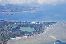
- hiking to the extinct volcano Dziani Dzaha of Petite-Terre and its lake Dziani ;
- hiking to Mount Combani and Mount Choungui;
- Trek to the governor's house;
- observation of the maki lemurs of the M'Bouzy islet;
- Diving and snorkeling on the coral reef among tropical fish in the "Passe en S", in N'Gouja, Saziley or on the outer barrier ;
- the lagoon allows the observation of green and hawksbill turtles (which come to lay their eggs on deserted beaches), dolphins (common long-billed, spotted and tursiops in particular), whales and their calves (which give birth there);
- nautical activities or relaxation on the many beaches of Mayotte;
- swimming and visits to the isolated beaches of the northern and southern white sand islets;
- bivouacs on the deserted islands;
- the Soulou waterfall, on the beach of the same name, is a natural curiosity;
- the Badamiers mudflat, in Petite-Terre, is a marsh rich in biodiversity and beautiful landscapes;
- the wrecks like that of the sailing schooner Dwyn Wen in front of the Badamiers (two masts of which are still standing out of the water);
- the tour of the island by microlight allows you to observe the reefs from the sky;
- the museum of Mayotte, the MuMa at Dzaoudzi, labeled Musée de France.
Several associations such as Les Naturalistes de Mayotte offer guided outings (hikes, visits, bivouacs...), and several marine operators accompany tourists to discover the lagoon and in particular its marine mammals, not to mention the many scuba diving clubs.
The departmental committee of tourism of Mayotte is the official body that administers everything related to tourism for the territory of Mayotte. It is in itself the central official authority that oversees the development and enhancement of tourism in Mayotte.

See also[]
- Outline of Mayotte
- 2008 invasion of Anjouan
- Administrative divisions of France
- Colonial and Departmental Heads of Mayotte
- Communications in Mayotte
- Islands administered by France in the Indian and Pacific oceans
- Music of the Comoro Islands
- Caring for the Lagoon, a documentary on the preservation of Mayotte's lagoon.
- Islam in Mayotte
Bibliography[]
- Olivier Hawlitschek, Rémy Eudeline & Antoine Rouillé, Terrestrial fauna of the Comoros Archipelago, (Field Guides, 2020), 338 p. (ISBN 979-10-699-5956-9).
References[]
- ^ Jump up to: a b c d e INSEE. "Estimation de population par région, sexe et grande classe d'âge – Années 1975 à 2021" (in French). Retrieved 22 March 2021.
- ^ Jump up to: a b c "Gross domestic product (GDP) at current market prices by NUTS 2 regions". Eurostat. Retrieved 22 March 2021.
- ^ Mayotte devient le 101e département français le 31 mars 2011 (PDF) (in French), Ministère de l'intérieur, de l'Outre-Mer, des collectivités territoriales et de l'immigration, p. 4, archived from the original (PDF) on 4 March 2016, retrieved 30 July 2015
- ^ "Mayotte : les langues en 2007 | Insee". www.insee.fr. Retrieved 16 July 2021.
- ^ "Ce qu'il faut savoir sur Mayotte, le 101e département français". LExpress.fr (in French). 12 March 2018. Retrieved 5 August 2021.
- ^ "Ce qu'il faut savoir sur Mayotte, le 101e département français". LExpress.fr (in French). 12 March 2018. Retrieved 5 August 2021.
- ^ Mayotte. Le gouvernement annonce 1,9 million d’euros pour le plan pauvreté à Mayotte.
- ^ Patrick Roger, Le gouvernement craint un regain des tensions sociales à Mayotte , Le Monde, 20 June 2019.
- ^ Jump up to: a b Zinke, J.; Reijmer, J. J. G.; Thomassin, B. A.; Dullo, W.-C.; Grootes, P. M.; Erlenkeuser, H. (2003). "Postglacial flooding history of Mayotte Lagoon (Comoro Archipelago, southwest Indian Ocean)". Marine Geology. 194 (3–4): 181–196. Bibcode:2003MGeol.194..181Z. doi:10.1016/S0025-3227(02)00705-3.
- ^ Jump up to: a b Ornella Lamberti, "L'île aux parfums : mémoires d'une indépendante", dans Glitter – hors-série spécial nouveaux arrivants, Mayotte, 2017
- ^ Volcano Discovery.
- ^ Jump up to: a b Nace, Trevor (3 December 2018). "Strange Waves Rippled Across Earth And Only One Person Spotted Them". Forbes. Retrieved 26 January 2019.
- ^ Berman, Robber (29 November 2018). "An unexplained seismic event 'rang' across the Earth in November". The Big Think Inc. Retrieved 26 January 2019.
- ^ AT Editor (17 May 2019). "Mayotte quake swarm linked to newly discovered undersea volcano". Africa Times. Retrieved 13 April 2021.
- ^ Ducarme, Frédéric (3 July 2017). "Du nouveau dans le lagon". Mayotte Hebdo. Retrieved 30 January 2020.
- ^ Jump up to: a b Découvrons Mayotte, on naturalistesmayotte.fr.
- ^ "Bras de fer franco-comorien au sujet de Mayotte". www.diploweb.com. Retrieved 12 December 2018.
- ^ "France Cast UN Veto". Pittsburgh Post-Gazette. 7 February 1976. Retrieved 13 April 2011.
The vote was 11–1 with three abstentions – the United States, Britain and Italy.
- ^ "Security Council – Veto List". UN. Retrieved 16 May 2020.
- ^ "Enquête sur le Futur 101e Département" (in French). 13 March 2009.
- ^ "Mayotte votes to become France's 101st department". The Telegraph. 29 March 2009. Retrieved 1 April 2011.
- ^ (in French) Mayotte vote en faveur de la départementalisation, Le Monde, 29 March 2009.
- ^ "Mayotte becomes 101st department". The Connexion. 31 March 2011. Retrieved 2 April 2011.
- ^ "Comoros". General Assembly of the United Nations. 26 September 2012. Retrieved 12 December 2018.
- ^ "Uneasy Calm on Mayotte after Anti-Immigration Protests". Future Directions International. 21 March 2018. Retrieved 4 February 2021.
- ^ "PHOTOS. Mayotte : la vie misérable à Kawéni, plus grand bidonville de France". Nouvelobs.com. Retrieved 3 May 2021.
- ^ Cannuel, Elise (31 March 2011). "EU shores spread to Indian Ocean island". Deutsche Welle.
- ^ "Mayotte accède à son statut de département dans la confusion". Le Monde.
- ^ Mielczarek, Marina (31 March 2011). "Mayotte devient le 101ème département français". Radio France Internationale.
- ^ "Council Directive 2013/61/EU of December 2013". 17 December 2013. Retrieved 1 January 2014.
- ^ Secretary-General of the European Commission. "Commission Opinion under Article 355(6) of the Treaty on the Functioning of the European Union on a French Government initiative to amend the status of Mayotte with regard to the European Union" (PDF). parlament.gv.at. COUNCIL OF THE EUROPEAN UNION. Retrieved 13 April 2021.
- ^ Minister of the Economy, Industry and Employment (France). "L'évolution du régime monétaire outre-mer" (in French). Archived from the original on 19 November 2004. Retrieved 30 November 2008.
- ^ INSEE. "Recensement 2017 - Quatre logements sur dix sont en tôle en 2017".
- ^ INSEE, Government of France. "256 500 habitants à Mayotte en 2017" (in French). Retrieved 1 January 2018.
- ^ INSEE, Government of France. "Figure 3 – Répartition de la population de Mayotte en 2017, par lieu de naissance et nationalité". Retrieved 8 April 2019.
- ^ INSEE, Government of France. "Population de Mayotte selon le lieu de naissance – RP 07" (in French). Archived from the original on 5 October 2013. Retrieved 4 October 2013.
- ^ INSEE, Government of France. "Les naissances en 2017 – État civil – Fichiers détail". Retrieved 8 April 2019.
- ^ "Europe | Mayotte backs French connection". BBC News. 29 March 2009. Retrieved 1 April 2011.
- ^ "CIA - The World Factbook -- Mayotte". teacherlink.ed.usu.edu. Retrieved 10 May 2021.
- ^ INSEE, Government of France. "LANG1M- Population de 14 ans ou plus par sexe, âge et langues parlées" (in French). Retrieved 10 October 2013.
- ^ Barreteau, Daniel. "Premiers résultats d'une enquête sociolinguistique auprès des élèves de CM2 de Mayotte" (PDF) (in French). Archived from the original (PDF) on 14 June 2007. Retrieved 17 May 2007.
- ^ Mayotte, Malango (2 October 2009). "Le shimaoré fout le camp" (in French). Archived from the original on 18 December 2013. Retrieved 10 October 2013.
- ^ Lambek, Michael 1988 Spirit Possession/Spirit Succession: Aspects of Social Continuity among Malagasy Speakers in Mayotte. American Ethnologist: 15 (4): 710–731.
External links[]
| Wikimedia Commons has media related to: Mayotte (category) |
| Wikivoyage has a travel guide for Mayotte. |
 Wikimedia Atlas of Mayotte
- Mayotte : a preserved archipelago – Official French website (in English)
- IleMayotte.com, the Mayotte Portal.
- Mayotte Archived 21 September 2012 at the Wayback Machine. The World Factbook. Central Intelligence Agency.
- Mayotte at Curlie
- Comité du tourisme de Mayotte Official tourism website (in French)
- Analysis of the linguistic situation on Mayotte (in French)

| show Articles relating to Mayotte |
|---|

| show Authority control |
|---|
- Mayotte
- Comoros archipelago
- Dependent territories in Africa
- Islands of Africa
- Island countries of the Indian Ocean
- Islands of Overseas France
- Overseas departments of France
- Outermost regions of the European Union
- East African countries
- Southeast African countries
- Disputed islands
- Disputed territories in Africa
- Territorial disputes of France
- Territorial disputes of the Comoros
- French-speaking countries and territories
- States and territories established in 1974
- 1974 establishments in Africa
- 1974 establishments in France
- Irredentism