Ashington, West Sussex
| Ashington | |
|---|---|
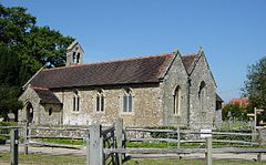 St Peter and St Paul's Church | |
 Ashington Location within West Sussex | |
| Area | 8.05 km2 (3.11 sq mi) [1] |
| Population | 2,351 [1] 2001 Census 2,526 (2011 Census)[2] |
| • Density | 292/km2 (760/sq mi) |
| OS grid reference | TQ131161 |
| • London | 41 miles (66 km) NNE |
| Civil parish |
|
| District |
|
| Shire county | |
| Region | |
| Country | England |
| Sovereign state | United Kingdom |
| Post town | PULBOROUGH |
| Postcode district | RH20 |
| Dialling code | 01903 |
| Police | Sussex |
| Fire | West Sussex |
| Ambulance | South East Coast |
| UK Parliament |
|
| Website | http://www.ashingtonpc.org.uk/ |

Ashington is a village and civil parish in the Horsham District of West Sussex, England. It lies on the A24 road 3 miles (4.8 km) northeast of Storrington.
The parish has a land area of 805 hectares (1989 acres). In the 2001 census 2351 people lived in 905 households, of whom 1286 were economically active. The 2011 Census population was 2,526[2]
The ancient Anglican parish church is dedicated to St Peter and St Paul.
Ashington won two regional categories (Business and Community Life) in the Calor Village of the Year competition in 2001 and was the overall Southern region winner in 2003.[3]
Metrobus operate bus route 23 which links the village to Worthing, Horsham and Crawley.
Sport[]
Ashington Cougars has football teams from under 6 to under 16 and play in the Horsham and District Youth Football League. Started in 1999 it has grown into a successful club attaining Charter Development status with Sussex FA in 2009, one of only 14 clubs in the whole of Sussex. 2011 saw the club become a finalist in the Sussex "Sports Club of the Year" awards where it was recognised for its work in player and community development.[4]
References[]
- ^ Jump up to: a b "2001 Census: West Sussex – Population by Parish" (PDF). West Sussex County Council. Archived from the original (PDF) on 8 June 2011. Retrieved 12 April 2009.
- ^ Jump up to: a b "Civil Parish population 2011". Neighbourhood Statistics. Office for National Statistics. Retrieved 27 September 2016.
- ^ Calor results website Archived September 15, 2008, at the Wayback Machine
- ^ "F A CHARTER STANDARD CLUBS" (PDF). The FA. 10 January 2011. Archived from the original (PDF) on 20 July 2011. Retrieved 17 May 2011.
External links[]
 Media related to Ashington, West Sussex at Wikimedia Commons
- Ashington in the Domesday Book
| show Authority control |
|---|
This West Sussex location article is a stub. You can help Wikipedia by . |
- Villages in West Sussex
- West Sussex geography stubs