RH postcode area
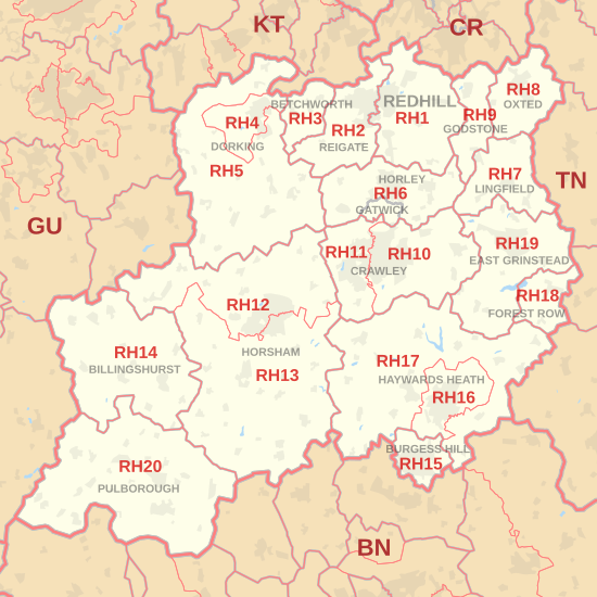
Postcode district boundaries:

Redhill | |
|---|---|
 RH | |
| Coordinates: 51°06′32″N 0°12′36″W / 51.109°N 0.210°W | |
| Country | United Kingdom |
| Postcode area | RH |
| Postcode area name | Redhill |
| Post towns | 17 |
| Postcode districts | 21 |
| Postcode sectors | 89 |
| Postcodes (live) | 16,011 |
| Postcodes (total) | 24,131 |
| Statistics as at May 2020[1] | |
The RH postcode area, also known as the Redhill postcode area,[2] is a group of twenty postcode districts in South East England, within seventeen post towns. These cover east Surrey (including Redhill, Reigate, Betchworth, Dorking, Lingfield, Horley, Oxted and Godstone) and northeastern West Sussex (including Crawley, Gatwick, Haywards Heath, Billingshurst, East Grinstead, Burgess Hill, Horsham and Pulborough) plus small parts of northwestern East Sussex (including Forest Row).
The main sorting office is in Crawley (Gatwick Mail Centre), and the area served includes parts of the Surrey districts of Guildford, Mole Valley, Reigate and Banstead and Tandridge, as well as most of the West Sussex districts of Crawley, Horsham and Mid Sussex, and small parts of the East Sussex districts of Lewes and Wealden.
Coverage[]
The approximate coverage of the postcode districts:
| Postcode district | Post town | Coverage | Local authority area(s) |
|---|---|---|---|
| RH1 | REDHILL | Redhill, Merstham, Earlswood, South Earlswood, Whitebushes, Salfords, Nutfield, Nutfield Marsh, South Nutfield, Bletchingley, Outwood | Reigate and Banstead, Tandridge |
| RH2 | REIGATE | Reigate, Woodhatch, South Park, Skimmington, Leigh, Dawes Green, Bunce Common, Shellwood Cross, Nalderswood, Sidlow, Irons Bottom | Reigate and Banstead, Mole Valley |
| RH3 | BETCHWORTH | Betchworth, Brockham, Buckland, Strood Green, Gadbrook | Mole Valley |
| RH4 | DORKING | Dorking, Pixham, Westcott | Mole Valley |
| RH5 | DORKING | Abinger, Capel, Westhumble, Mickleham, Ockley, Holmbury St Mary, Beare Green | Mole Valley, Guildford |
| RH6 | GATWICK | Gatwick Airport | Crawley |
| HORLEY | Horley, Burstow, Smallfield | Reigate and Banstead, Crawley, Mole Valley, Tandridge | |
| RH7 | LINGFIELD | Lingfield, Dormansland, Crowhurst | Tandridge |
| RH8 | OXTED | Oxted, Limpsfield, Limpsfield Chart, Hurst Green, Merle Common, Tandridge, Crowhurst Lane End | Tandridge |
| RH9 | GODSTONE | Godstone, South Godstone | Tandridge |
| RH10 | CRAWLEY | Copthorne, Crawley Down, Domewood, Furnace Green, Northgate, Maidenbower, Pound Hill, Rowfant, Southgate, Three Bridges, Tilgate | Crawley, Mid Sussex |
| RH11 | CRAWLEY | Bewbush, Broadfield, Gossops Green, Ifield, Langley Green, Lowfield Heath, Pease Pottage, Southgate West, West Green | Crawley, Mid Sussex, Horsham |
| RH12 | HORSHAM | Horsham, Broadbridge Heath, Rusper, Rudgwick, Warnham | Horsham |
| RH13 | HORSHAM | Barns Green, Cowfold, Mannings Heath, Partridge Green, Slinfold, Southwater, West Grinstead | Horsham |
| RH14 | BILLINGSHURST | Billingshurst, Ifold, Kirdford, Loxwood, Plaistow, Wisborough Green | Chichester, Horsham |
| RH15 | BURGESS HILL | Burgess Hill, Ditchling Common | Mid Sussex, Lewes |
| RH16 | HAYWARDS HEATH | Haywards Heath, Lindfield | Mid Sussex |
| RH17 | HAYWARDS HEATH | Ansty, Ardingly, Balcombe, Bolney, Chelwood Gate, Cuckfield, Danehill, Handcross, Hickstead, Horsted Keynes, Wivelsfield, Wivelsfield Green | Mid Sussex, Lewes, Wealden |
| RH18 | FOREST ROW | Forest Row | Wealden |
| RH19 | EAST GRINSTEAD | East Grinstead, Ashurst Wood, Dormans Park, Felbridge, Felcourt, Hammerwood, Sharpthorne, West Hoathly | Mid Sussex, Tandridge |
| RH20 | PULBOROUGH | Pulborough, Ashington, Storrington, West Chiltington, West Chiltington Common, Bury, Watersfield, Sutton, Fittleworth | Chichester, Horsham |
| RH77 | REDHILL | Jobcentre Plus | non-geographic |
Map[]
| ( • help)
|
See also[]
References[]
- ^ "ONS Postcode Directory Version Notes" (ZIP). National Statistics Postcode Products. Office for National Statistics. May 2020. Table 2. Retrieved 19 June 2020. Coordinates from mean of unit postcode points, "Code-Point Open". OS OpenData. Ordnance Survey. February 2012. Retrieved 21 April 2012.
- ^ Royal Mail, Address Management Guide, (2004)
External links[]
- Crawley
- Postcode areas covering South East England