BH postcode area
Postcode district boundaries:

Bournemouth | |
|---|---|
 BH | |
| Coordinates: 50°45′00″N 1°53′31″W / 50.750°N 1.892°W | |
| Country | United Kingdom |
| Postcode area | BH |
| Postcode area name | Bournemouth |
| Post towns | 11 |
| Postcode districts | 26 |
| Postcode sectors | 103 |
| Postcodes (live) | 15,163 |
| Postcodes (total) | 22,188 |
| Statistics as at May 2020[1] | |
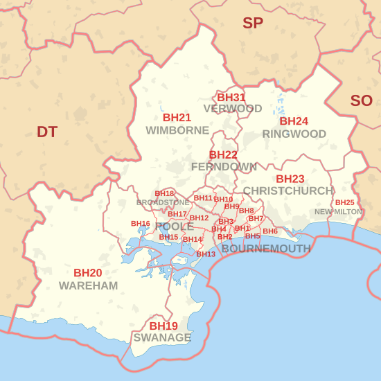
The BH postcode area, also known as the Bournemouth postcode area,[2] is a group of 26 postcode districts in southern England, within eleven post towns. These cover east Dorset (including Bournemouth, Poole, Broadstone, Christchurch, Ferndown, Swanage, Verwood, Wareham and Wimborne) and part of south-west Hampshire (including New Milton and Ringwood).
Coverage[]
The approximate coverage of the postcode districts:
| Postcode district | Post town | Coverage | Local authority area(s) |
|---|---|---|---|
| BH1 | BOURNEMOUTH | Bournemouth Town Centre, East Cliff, Springbourne, Boscombe town centre | Bournemouth, Christchurch and Poole |
| BH2 | BOURNEMOUTH | Bournemouth Town Centre, West Cliff | Bournemouth, Christchurch and Poole |
| BH3 | BOURNEMOUTH | Talbot Woods, Winton south | Bournemouth, Christchurch and Poole |
| BH4 | BOURNEMOUTH | Westbourne, Branksome Woods | Bournemouth, Christchurch and Poole |
| BH5 | BOURNEMOUTH | Boscombe, Pokesdown | Bournemouth, Christchurch and Poole |
| BH6 | BOURNEMOUTH | Southbourne, Tuckton, Wick | Bournemouth, Christchurch and Poole |
| BH7 | BOURNEMOUTH | Littledown, Iford | Bournemouth, Christchurch and Poole |
| BH8 | BOURNEMOUTH | Bournemouth railway station, Malmesbury Park, Richmond Park, Queens Park, Charminster, Strouden Park, Townsend, Holdenhurst, Throop | Bournemouth, Christchurch and Poole |
| BH9 | BOURNEMOUTH | Winton, Moordown, Throop, Muscliff | Bournemouth, Christchurch and Poole |
| BH10 | BOURNEMOUTH | Kinson, East Howe, Northbourne, Redhill, Ensbury Park, Slades Farm, Talbot Village, Wallisdown | Bournemouth, Christchurch and Poole |
| BH11 | BOURNEMOUTH | Kinson, Bear Cross, West Howe, Wallisdown, Bearwood | Bournemouth, Christchurch and Poole |
| BH12 | POOLE | Branksome, Alderney, Upper Parkstone, Newtown, Bournemouth University | Bournemouth, Christchurch and Poole |
| BH13 | POOLE | Canford Cliffs, Sandbanks, Branksome Park, Brownsea Island | Bournemouth, Christchurch and Poole; Dorset |
| BH14 | POOLE | Lower Parkstone, Lilliput, Penn Hill | Bournemouth, Christchurch and Poole |
| BH15 | POOLE | Poole Town Centre, Hamworthy, Longfleet, Oakdale, Poole Harbour minor islands | Bournemouth, Christchurch and Poole; Dorset |
| BH16 | POOLE | Upton, Turlin Moor, Lytchett Minster, Lytchett Matravers, Holton Heath | Dorset; Bournemouth, Christchurch and Poole |
| BH17 | POOLE | Canford Heath, Creekmoor | Bournemouth, Christchurch and Poole |
| BH18 | BROADSTONE | Broadstone | Bournemouth, Christchurch and Poole |
| BH19 | SWANAGE | Swanage, Studland, Langton Matravers, Worth Matravers | Dorset |
| BH20 | WAREHAM | Wareham, Arne, Corfe Castle, West Lulworth, Wool, Bovington Camp, Bere Regis | Dorset |
| BH21 | WIMBORNE | Wimborne, Corfe Mullen, Sturminster Marshall, Cranborne, Merley, Oakley, Three Legged Cross, Knowlton | Dorset; Bournemouth, Christchurch and Poole |
| BH22 | FERNDOWN | Ferndown, West Moors, West Parley | Dorset |
| BH23 | CHRISTCHURCH | Christchurch, Highcliffe, Burton, Sopley, Bransgore, Hurn, Bournemouth Airport | Bournemouth, Christchurch and Poole; New Forest |
| BH24 | RINGWOOD | Ringwood, St Leonards, Ashley Heath, Burley, Holmsley | New Forest; Dorset |
| BH25 | NEW MILTON | New Milton, Barton on Sea, Bashley, Wootton, Ossemsley | New Forest |
| BH31 | VERWOOD | Verwood | Dorset |
Map[]
| ( • help)
|
See also[]
References[]
- ^ "ONS Postcode Directory Version Notes" (ZIP). National Statistics Postcode Products. Office for National Statistics. May 2020. Table 2. Retrieved 19 June 2020. Coordinates from mean of unit postcode points, "Code-Point Open". OS OpenData. Ordnance Survey. February 2012. Retrieved 21 April 2012.
- ^ Royal Mail, Address Management Guide, (2004)
External links[]
Categories:
- Postcode areas covering South West England