CV postcode area
Postcode district boundaries:
Coventry | |
|---|---|
 CV | |
| Coordinates: 52°22′19″N 1°30′07″W / 52.372°N 1.502°W | |
| Country | United Kingdom |
| Postcode area | CV |
| Postcode area name | Coventry |
| Post towns | 11 |
| Postcode districts | 24 |
| Postcode sectors | 104 |
| Postcodes (live) | 20,320 |
| Postcodes (total) | 28,094 |
| Statistics as at May 2020[1] | |
The CV postcode area, also known as the Coventry postcode area,[2] is a group of 24 postcode districts in central England, within eleven post towns. These cover the eastern part of the West Midlands (including Coventry), most of Warwickshire (including Atherstone, Bedworth, Kenilworth, Leamington Spa, Nuneaton, Rugby, Shipston-on-Stour, Southam, Stratford-upon-Avon and Warwick), a part of west Leicestershire and a very small part of Northamptonshire.
Coverage[]
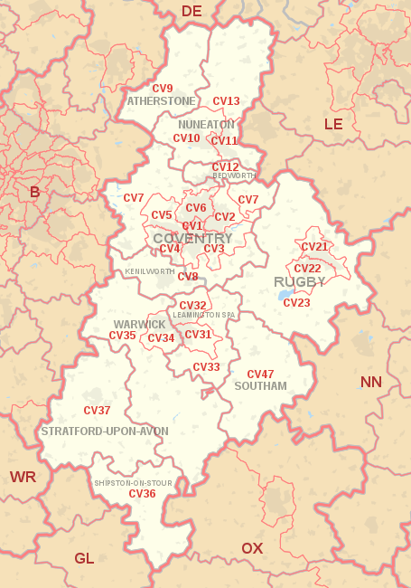
The approximate coverage of the postcode districts:
| Postcode district | Post town | Coverage | Local authority area(s) |
|---|---|---|---|
| CV1 | COVENTRY | Coventry C (Coventry City Centre, Gosford Green, Hillfields, Spon End, Coventry University) | Coventry |
| CV2 | COVENTRY | Coventry NE (Walsgrave, Wyken, Stoke, Bell Green, Wood End, Potters Green, Aldermans Green, Clifford Park, Woodway Park) | Coventry |
| CV3 | COVENTRY | Coventry SE (Binley, Whitley, Willenhall, Cheylesmore, Styvechale, Finham, Fenside, Stoke Aldermoor, Green Lane, Ernesford Grange, Binley Woods) | Coventry, Rugby |
| CV4 | COVENTRY | Coventry SW (Tile Hill, Canley, Cannon Park, Lime Tree Park, Gibbet Hill, Westwood Heath, University of Warwick) | Coventry |
| CV5 | COVENTRY | Coventry NW (Allesley, Allesley Park, Allesley Green, Earlsdon, Eastern Green, Whoberley, Chapelfields, Mount Nod, Brownshill Green) | Coventry |
| CV6 | COVENTRY | Coventry N (Holbrooks, Coundon, Radford, Longford, Rowley's Green, Courthouse Green, Whitmore Park), Hawkesbury | Coventry, Nuneaton and Bedworth |
| CV7 | COVENTRY | Exhall, Ash Green, Keresley, Meriden, Balsall Common, Berkswell, Corley, Arley, Ansty, Shilton, Fillongley | Nuneaton and Bedworth, North Warwickshire, Coventry, Rugby, Solihull |
| CV8 | COVENTRY | Wolston, Ryton-on-Dunsmore | Warwick, Rugby |
| KENILWORTH | Kenilworth, Baginton, Bubbenhall, Burton Green, Brandon, Stoneleigh, Ashow | ||
| CV9 | ATHERSTONE | Atherstone, Mancetter, Grendon, Baddesley Ensor, Baxterley, Hurley, Witherley, Wood End, Twycross, Orton On The Hill, Ridge Lane Village | North Warwickshire, Hinckley and Bosworth |
| CV10 | NUNEATON | Nuneaton N & W (Weddington, Stockingford, Camp Hill, Galley Common, Grove Farm, Whittleford, Chapel End, Bermuda Village), Caldecote, Fenny Drayton, Hartshill, Ansley, Astley, Oldbury, Ridge Lane | Nuneaton and Bedworth, North Warwickshire |
| CV11 | NUNEATON | Nuneaton C & E (town centre, Abbey Green, St Nicolas Park, Horeston Grange, Attleborough, Whitestone, Hill Top, Chilvers Coton, Caldwell), Burton Hastings, Bramcote | Nuneaton and Bedworth, Rugby, Hinckley and Bosworth |
| CV12 | BEDWORTH | Bedworth (except Exhall and Ash Green), Bulkington | Nuneaton and Bedworth |
| CV13 | NUNEATON | Barlestone, Barton in the Beans, Bilstone, Cadeby, Carlton, Congerstone, Dadlington, Fenny Drayton, Higham on the Hill, Market Bosworth, Nailstone, Odstone, Osbaston, Shackerstone, Shenton, Stoke Golding, Sutton Cheney, Upton, Wellsborough | Hinckley and Bosworth |
| CV21 | RUGBY | Rugby (north), Brownsover | Rugby |
| CV22 | RUGBY | Rugby (south), Bilton, Cawston, Dunchurch | Rugby |
| CV23 | RUGBY | Thurlaston, Princethorpe, Stretton-on-Dunsmore, Birdingbury, Brinklow, Long Lawford, Clifton upon Dunsmore, Stretton-under-Fosse, Monks Kirby, Kilsby | Rugby, West Northamptonshire |
| CV31 | LEAMINGTON SPA | Leamington Spa (south), Sydenham, Whitnash, Radford Semele | Warwick |
| CV32 | LEAMINGTON SPA | Leamington Spa (north), Cubbington, Lillington | Warwick |
| CV33 | LEAMINGTON SPA | Harbury and surrounding villages | Warwick, Stratford-on-Avon |
| CV34 | WARWICK | Warwick | Warwick |
| CV35 | WARWICK | Wellesbourne, Gaydon, Kineton and surrounding villages | Warwick, Stratford-on-Avon |
| CV36 | SHIPSTON-ON-STOUR | Shipston-on-Stour and surrounding villages | Stratford-on-Avon |
| CV37 | STRATFORD-UPON-AVON | Stratford-upon-Avon and surrounding villages | Stratford-on-Avon |
| CV47 | SOUTHAM | Southam and surrounding villages | Stratford-on-Avon |
The CV47 district was formed in 1999 from parts of the CV23 and CV33 districts.[3]
Map[]
| ( • help)
|
See also[]
- List of postcode areas in the United Kingdom
- Centre points of the United Kingdom
- Postcode Address File
References[]
- ^ "ONS Postcode Directory Version Notes" (ZIP). National Statistics Postcode Products. Office for National Statistics. May 2020. Table 2. Retrieved 19 June 2020. Coordinates from mean of unit postcode points, "Code-Point Open". OS OpenData. Ordnance Survey. February 2012. Retrieved 21 April 2012.
- ^ Royal Mail, Address Management Guide, (2004)
- ^ "Royal Mail Postcode Update 29". Beacon Dodsworth. Archived from the original on 23 April 2017. Retrieved 22 April 2017.
External links[]
Categories:
- Coventry
- Postcode areas covering the West Midlands (region)
- Postcode areas covering the East Midlands