NG postcode area
Postcode district boundaries:

Nottingham | |
|---|---|
 NG | |
| Coordinates: 53°00′32″N 1°03′54″W / 53.009°N 1.065°W | |
| Country | United Kingdom |
| Postcode area | NG |
| Postcode area name | Nottingham |
| Post towns | 7 |
| Postcode districts | 32 |
| Postcode sectors | 167 |
| Postcodes (live) | 28,773 |
| Postcodes (total) | 37,189 |
| Statistics as at May 2020[1] | |
The NG postcode area, also known as the Nottingham postcode area,[2] is a group of 29 postcode districts in the East Midlands of England, which are subdivisions of seven post towns. These cover central Nottinghamshire (including Nottingham, Mansfield, Sutton-in-Ashfield, Newark-on-Trent and Southwell), parts of south-west Lincolnshire (including Grantham and Sleaford) and small parts of Derbyshire and Leicestershire.
Coverage[]
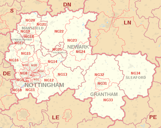
The approximate coverage of the postcode districts:
| Postcode district | Post town | Coverage | Local authority area(s) |
|---|---|---|---|
| NG1 | NOTTINGHAM | Nottingham city centre | Nottingham |
| NG2 | NOTTINGHAM | Nottingham city centre, Colwick Park, Sneinton, The Meadows, West Bridgford | Nottingham, Rushcliffe |
| NG3 | NOTTINGHAM | Carlton, Sneinton, St Ann's, Mapperley | Gedling, Nottingham |
| NG4 | NOTTINGHAM | Gedling Village, Netherfield, Carlton, Colwick | Gedling |
| NG5 | NOTTINGHAM | Sherwood, Arnold, Bestwood, Carrington, Top Valley, Rise Park | Nottingham, Gedling |
| NG6 | NOTTINGHAM | Bestwood Village, Bulwell, Old Basford | Nottingham, Gedling |
| NG7 | NOTTINGHAM | New Basford, Forest Fields, Hyson Green, Radford, Lenton | Nottingham |
| NG8 | NOTTINGHAM | Aspley, Wollaton, Whitemoor, Bilborough, Strelley | Nottingham, Broxtowe |
| NG9 | NOTTINGHAM | Beeston, Stapleford, Lenton Abbey, Chilwell, Trowell, Bramcote | Broxtowe, Nottingham |
| NG10 | NOTTINGHAM | Long Eaton, Sawley, Sandiacre | Erewash |
| NG11 | NOTTINGHAM | Clifton, Ruddington, Gotham, Kingston on Soar | Nottingham, Rushcliffe |
| NG12 | NOTTINGHAM | Cotgrave, Radcliffe on Trent, Keyworth, Edwalton | Rushcliffe |
| NG13 | NOTTINGHAM | Bingham, Whatton, Bottesford, Aslockton | Rushcliffe, Melton |
| NG14 | NOTTINGHAM | Calverton, Lowdham, Burton Joyce, Gunthorpe | Gedling |
| NG15 | NOTTINGHAM | Hucknall, Ravenshead, Newstead | Ashfield, Gedling |
| NG16 | NOTTINGHAM | Kimberley, Eastwood, Nuthall, Langley Mill, Pinxton, Selston, Awsworth, Ironville, Jacksdale, , Underwood, Brinsley, Watnall | Amber Valley, Ashfield Bolsover, Broxtowe |
| NG17 | NOTTINGHAM | Kirkby-in-Ashfield | Ashfield |
| SUTTON-IN-ASHFIELD | Sutton-in-Ashfield, Stanton Hill, Skegby | ||
| NG18 | MANSFIELD | Mansfield | Mansfield |
| NG19 | MANSFIELD | Mansfield Woodhouse, Forest Town | Mansfield |
| NG20 | MANSFIELD | Shirebrook, Market Warsop | Bolsover, Mansfield |
| NG21 | MANSFIELD | Rainworth, Edwinstowe, Clipstone, Blidworth | Newark and Sherwood |
| NG22 | NEWARK | Bilsthorpe, Newark-on-Trent | Newark and Sherwood |
| NG23 | NEWARK | Newark-on-Trent, Collingham, Long Bennington | Newark and Sherwood |
| NG24 | NEWARK | Newark-on-Trent, Balderton | Newark and Sherwood |
| NG25 | SOUTHWELL | Southwell | Newark and Sherwood |
| NG31 | GRANTHAM | Grantham | South Kesteven |
| NG32 | GRANTHAM | Grantham, Croxton Kerrial, Sedgebrook | South Kesteven, Melton |
| NG33 | GRANTHAM | Grantham, Castle Bytham, Corby Glen | South Kesteven |
| NG34 | SLEAFORD | Sleaford, Scredington | North Kesteven |
| NG70 | MANSFIELD | Special Business Reply Service | non-geographic |
| NG80 | NOTTINGHAM | Experian | non-geographic |
| NG90 | NOTTINGHAM | Boots UK | non-geographic |
Map[]
| ( • help)
|

Detailed map of postcode districts in central Nottingham
See also[]
References[]
- ^ "ONS Postcode Directory Version Notes" (ZIP). National Statistics Postcode Products. Office for National Statistics. May 2020. Table 2. Retrieved 19 June 2020. Coordinates from mean of unit postcode points, "Code-Point Open". OS OpenData. Ordnance Survey. February 2012. Retrieved 21 April 2012.
- ^ Royal Mail, Address Management Guide, (2004)
External links[]
Categories:
- Nottingham
- Postcode areas covering the East Midlands