TS postcode area
Postcode district boundaries:

Cleveland | |
|---|---|
 TS | |
| Coordinates: 54°35′06″N 1°13′19″W / 54.585°N 1.222°W | |
| Country | United Kingdom |
| Postcode area | TS |
| Postcode area name | Cleveland |
| Post towns | 10 |
| Postcode districts | 30 |
| Postcode sectors | 103 |
| Postcodes (live) | 17,477 |
| Postcodes (total) | 22,898 |
| Statistics as at May 2020[1] | |
The TS postcode area, also known as the Cleveland postcode area,[2] (or unofficially as the Teesside postcode area) is a group of 29 postcode districts in north-east England for ten post towns. These cover north-east North Yorkshire (post towns Middlesbrough, Redcar, Saltburn-by-the-Sea, Guisborough and Yarm) and south-east County Durham (post towns Stockton-on-Tees, Hartlepool, Billingham, Wingate and Trimdon Station).
Coverage[]
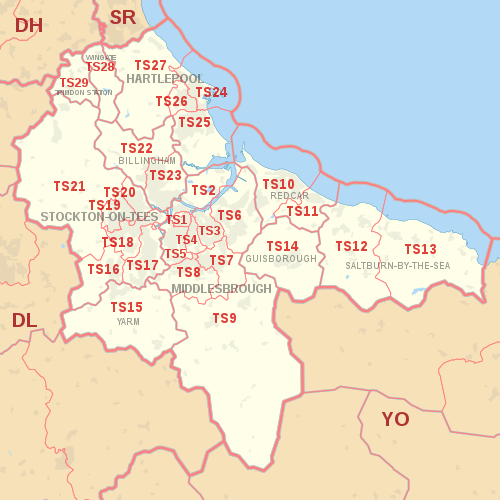
The approximate coverage of the postcode districts:
| Postcode district | Post town | Coverage | Local authority area(s) |
|---|---|---|---|
| TS1 | MIDDLESBROUGH | Town Centre (Gresham, University, Abingdon) | Middlesbrough |
| TS2 | MIDDLESBROUGH | Middlehaven, Port Clarence | Middlesbrough, Stockton-on-Tees |
| TS3 | MIDDLESBROUGH | Brambles Farm, Thorntree, Park End, North Ormesby, Berwick Hills | Middlesbrough |
| TS4 | MIDDLESBROUGH | Grove Hill, Longlands | Middlesbrough |
| TS5 | MIDDLESBROUGH | Acklam, Linthorpe | Middlesbrough |
| TS6 | MIDDLESBROUGH | Eston, Grangetown, Normanby, Teesville, South Bank | Redcar & Cleveland |
| TS7 | MIDDLESBROUGH | Marton, Nunthorpe, Ormesby | Middlesbrough, Redcar & Cleveland |
| TS8 | MIDDLESBROUGH | Coulby Newham, Marton, Hemlington Stainton, Thornton & Maltby | Middlesbrough, Stockton-on-Tees |
| TS9 | MIDDLESBROUGH | Great Ayton, Stokesley | Hambleton |
| TS10 | REDCAR | Redcar | Redcar & Cleveland |
| TS11 | REDCAR | Marske-by-the-Sea, New Marske | Redcar & Cleveland |
| TS12 | SALTBURN-BY-THE-SEA | Saltburn-by-the-Sea, Skelton-in-Cleveland, Brotton | Redcar & Cleveland |
| TS13 | SALTBURN-BY-THE-SEA | Loftus, Skinningrove, Staithes | Redcar & Cleveland, Scarborough |
| TS14 | GUISBOROUGH | Guisborough | Redcar & Cleveland |
| TS15 | YARM | Yarm, Kirklevington | Stockton-on-Tees |
| TS16 | STOCKTON-ON-TEES | Eaglescliffe, Egglescliffe, Aislaby | Stockton-on-Tees |
| TS17 | STOCKTON-ON-TEES | Thornaby, Ingleby Barwick, Stainton (part) | Stockton-on-Tees, Middlesbrough |
| TS18 | STOCKTON-ON-TEES | Central, Hartburn, Preston-on-Tees, Grangefield, Oxbridge, Portrack | Stockton-on-Tees, County Durham |
| TS19 | STOCKTON-ON-TEES | Newtown, Fairfield, Hardwick, Roseworth, Bishopsgarth, Elm Tree Farm | Stockton-on-Tees |
| TS20 | STOCKTON-ON-TEES | Norton, Mount Pleasant | Stockton-on-Tees |
| TS21 | STOCKTON-ON-TEES | Stillington, Bishopton, Redmarshall, Thorpe Thewles, Carlton, Sedgefield, Long Newton | Stockton-on-Tees |
| TS22 | BILLINGHAM | Billingham (West), Wolviston, Wynyard | Stockton-on-Tees |
| TS23 | BILLINGHAM | Billingham (East) | Stockton-on-Tees |
| TS24 | HARTLEPOOL | Hartlepool town centre, Hartlepool Marina, Stranton, Belle Vue, Headland | Hartlepool |
| TS25 | HARTLEPOOL | Seaton Carew, Fens Estate, Owton Manor, Rift House, Greatham | Hartlepool |
| TS26 | HARTLEPOOL | Middle Warren, Upper Warren, Bishop Cuthbert, Throston, West Park | Hartlepool |
| TS27 | HARTLEPOOL | Blackhall Rocks, Blackhall Colliery, Castle Eden, Hesleden, High Hesleden, Hutton Henry | Hartlepool, County Durham |
| TS28 | WINGATE | Wingate, Station Town | County Durham |
| TS29 | TRIMDON STATION | Trimdon | County Durham |
Map[]
| ( • help)
|
See also[]
References[]
- ^ "ONS Postcode Directory Version Notes" (ZIP). National Statistics Postcode Products. Office for National Statistics. May 2020. Table 2. Retrieved 19 June 2020. Coordinates from mean of unit postcode points, "Code-Point Open". OS OpenData. Ordnance Survey. February 2012. Retrieved 21 April 2012.
- ^ Royal Mail, Address Management Guide, (2004)
External links[]
Categories:
- Postcode areas covering North East England