BB postcode area
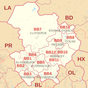
Postcode district boundaries:
Blackburn | |
|---|---|
 BB | |
| Coordinates: 53°47′06″N 2°20′06″W / 53.785°N 2.335°W | |
| Country | United Kingdom |
| Postcode area | BB |
| Postcode area name | Blackburn |
| Post towns | 9 |
| Postcode districts | 15 |
| Postcode sectors | 79 |
| Postcodes (live) | 13,200 |
| Postcodes (total) | 18,833 |
| Statistics as at May 2020[1] | |
The BB postcode area, also known as the Blackburn postcode area,[2] is a group of thirteen postcode districts in north-west England, within nine post towns. These cover east Lancashire, including Blackburn, Burnley, Accrington, Barnoldswick, Clitheroe, Colne, Darwen, Nelson and Rossendale.
Coverage[]
The approximate coverage of the postcode districts:
| Postcode district | Post town | Coverage | Local authority area(s) |
|---|---|---|---|
| BB0 | BLACKBURN | Granby Marketing, Blackburn[3] | non-geographic |
| BB1 | BLACKBURN | Blackburn (east), Bank Hey, Belthorn (part), Blackamoor, Clayton-le-Dale, Guide, Knuzden, Mellor, Ramsgreave, Rishton, Salesbury, Shadsworth, Sunnybower, Tottleworth, Whitebirk, Wilpshire | Blackburn with Darwen, Hyndburn, Ribble Valley |
| BB2 | BLACKBURN | Blackburn (west), Beardwood, Balderstone, Belthorn (part), Cherry Tree, Feniscowles, , , Livesey, Mellor, Mellor Brook, , Osbaldeston, Pleasington, | Blackburn with Darwen, Chorley, Ribble Valley, South Ribble |
| BB3 | DARWEN | Darwen, Bank Fold, Eccleshill, Hoddlesden, Livesey, Lower Darwen, Pickup Bank, Tockholes | Blackburn with Darwen |
| BB4 | ROSSENDALE | Acre, Balladen, Bent Gate, Cloughfold, Cowpe, Crawshawbooth, Haslingden, Helmshore, Lumb (near Rawtenstall), Newchurch, Rawtenstall, Waterfoot, Weir | Rossendale |
| BB5 | ACCRINGTON | Accrington, Altham, Baxenden, Church, Clayton-le-Moors, Huncoat, Oswaldtwistle, | Hyndburn, Rossendale |
| BB6 | BLACKBURN | Dinckley, Great Harwood, Langho | Hyndburn, Ribble Valley |
| BB7 | CLITHEROE | Clitheroe, Barrow, Bashall Eaves, Billington, Bolton-by-Bowland, Chatburn, Downham, Dunsop Bridge, Gisburn, Great Mitton, Grindleton, Hurst Green, Little Mitton, Middop, Newsholme, Newton-in-Bowland, Paythorne, Pendleton, Rimington, Sabden, Sawley, Slaidburn, Twiston, Waddington, Whalley, Whitewell, Wiswell, Worston | Ribble Valley |
| BB8 | COLNE | Colne, Foulridge, Laneshaw Bridge, Trawden, Winewall, Wycoller | Pendle |
| BB9 | NELSON | Nelson, Barrowford, Blacko, Brierfield, Higherford, Roughlee | Pendle |
| BB10 | BURNLEY | Burnley (east), Cliviger, Haggate, Harle Syke, Reedley, Worsthorne | Burnley, Pendle |
| BB11 | BURNLEY | Burnley (south and town centre), Dunnockshaw and Clowbridge, Hapton | Burnley |
| BB12 | BURNLEY | Burnley (west), Barley, Fence, Hapton, Higham, Padiham, Read, Simonstone, Wheatley Lane | Burnley, Pendle, Ribble Valley |
| BB18 | BARNOLDSWICK | Barnoldswick, Bracewell and Brogden, Earby, Kelbrook, Salterforth, Sough | Pendle |
| BB94 | BARNOLDSWICK | Holiday Cottages Group, Earby[3] | non-geographic |
The BB18 district was formed out of the BB8 district in 1997.[4]
Map[]
| ( • help)
|
See also[]
- List of postcode areas in the United Kingdom
- Centre points of the United Kingdom
- Postcode Address File
References[]
- ^ "ONS Postcode Directory Version Notes" (ZIP). National Statistics Postcode Products. Office for National Statistics. May 2020. Table 2. Retrieved 19 June 2020. Coordinates from mean of unit postcode points, "Code-Point Open". OS OpenData. Ordnance Survey. February 2012. Retrieved 21 April 2012.
- ^ Royal Mail, Address Management Guide, (2004)
- ^ a b "Royal Mail non-geographic postcodes" (PDF). Royal Mail. 7 March 2007. Retrieved 10 March 2008.[permanent dead link]
- ^ "Which districts have been recoded by the Royal Mail?". Experian Data Quality Support. Retrieved 22 April 2017.
External links[]
Categories:
- Blackburn with Darwen
- Postcode areas covering North West England
- Lancashire-related lists

