Oxted
| Oxted | |
|---|---|
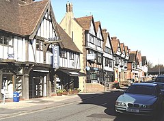 The timber-framed stucco façades of buildings in Oxted | |
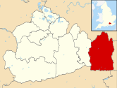
 Oxted Location within Surrey | |
| Area | 15.15 km2 (5.85 sq mi) |
| Population | 11,314 (Civil Parish 2011)[1] or 13,452 as to Built-up Area [2] |
| • Density | 747/km2 (1,930/sq mi) |
| OS grid reference | TQ3953 |
| • London | 17.9 mi (28.8 km) |
| Civil parish |
|
| District | |
| Shire county | |
| Region | |
| Country | England |
| Sovereign state | United Kingdom |
| Post town | Oxted |
| Postcode district | RH8 |
| Dialling code | 01883 |
| Police | Surrey |
| Fire | Surrey |
| Ambulance | South East Coast |
| UK Parliament | |
Oxted is a town and civil parish in the Tandridge district of Surrey, England, at the foot of the North Downs. It is 9 miles (14 km) south south-east of Croydon in Greater London, 8.5 miles (13.7 km) west of Sevenoaks in Kent, and 9 miles (14 km) north of East Grinstead in West Sussex.
Oxted is a commuter town with a railway station, with direct train services to London and has the district council offices. Its main developed area is contiguous with the village of Limpsfield. Six intermittent headwaters of the River Eden unite in the occasional market town including its furthest source, east of Titsey Place. The Eden feeds into Kent's longest river, the Medway. Only the southern slope of the North Downs is steep and its towns and farmland form the Vale of Holmesdale, a series of headwaters across Surrey and Kent to separate rivers.
The settlements of Hurst Green and Holland within the civil parish to the south, including a public house named after Oxted, are continuous but almost wholly residential areas (contiguous neighbourhoods).
Toponymy[]
The first written mention of Oxted is from an Anglo-Saxon charter of 862 AD, in which it appears as Acustyde.[3] In the Domesday Book of 1086, the settlement is recorded as Acstede.[4] In later documents, it appears as Akested (12th century), Axsted, Axstude and Ocsted (13th century) and Oxsted (14th century).[5] The name derives from the Old English āc meaning "oak" and stede meaning "place". Oxted is generally agreed to mean "place of oak trees". [4][5]
Hurst Green is first recorded in the mid-15th century as le Herst in a deed of Edward IV and as Herste grene in 1577. The name is thought to mean "open space by the wood (hurst)".[3] "Holland" appears in 1757 as Hollands[5] and is thought to mean "land by the hill".[6]
History[]
Early history[]
The earliest evidence of human activity in the civil parish is from the Iron Age and finds include a metal brooch dating from the 3rd or 4th centuries BCE.[7] During the Roman period, the roads from London to Lewes and London to Brighton ran either side of Oxted.[8] The name Oxted suggests that the modern settlement was founded in the Anglo-Saxon period and it is possible that St Mary's Church is built on a pre-Christian religious site.[9][10] From late Saxon times, the area was administered as part of the Tandridge Hundred.[11]
Mills and manors[]
Oxted appears in the Domesday Book as Acsted and was held by Eustace II, Count of Boulogne.[12][note 1] Its Domesday assets were: 5 hides; 1 church, 2 mills worth 12s 6d, 20 ploughs, 4 acres (1.6 ha) of meadow, pannage worth 100 hogs. It rendered £14 and 2d from a house in Southwark to its feudal overlords per year.[14]
Three mills are mentioned in the inquisition on Roland of Oxted, 1291–2. To a greater or lesser extent these were alienated from the main manor, which had become one of four, before 1689, when they were in the possession of Thomas Causton. In 1712 only one is mentioned as appertaining to the manor. The five manors were: Oxted, Barrow Green, Bursted/Bearsted, Broadham, Stocketts and Foyle.
The history of the first suggests wealthy tranche of the parish and is instructive as to social history; by marriage it became by agreed settlement a manor of Ralph Earl of Westmorland, with remainder to Thomas Cobham, his wife's uncle. Margaret died in 1460, leaving no children and her husband held the manor until his death in 1485, when it passed to Anne, only child and heir of Thomas Cobham, who had married Sir Edward Burgh. She died in 1526, and her husband, who 'became distracted of memorie,' died two years later, leaving a son and heir Thomas, afterwards created the Lord Burgh.[15]
Civil development and expansion from village into a commuter town[]
The original village of Oxted (now Old Oxted) is a small village centred on a short high street with four pubs (The Old Bell, The George Inn, The Crown Inn and The Wheatsheaf) just off the A25. Oxted's oldest church which still provides services, St Mary's, was built in a field, upstream from and north-east of the medieval heart of Oxted, near Master Park and the railway station. The Grade I listed church dates from at least Norman times and stands on a conspicuous mound.[16]
With the arrival of the railway in 1884 (after many years' delay caused by lack of funds) Oxted boomed in line with London's trade growth around its station, north-east of Old Oxted, and new buildings created "New Oxted". These new buildings were built in the Tudor style, particularly with stucco frontages. All Saints Catholic Church was built in 1913–1928 designed by Arts & Crafts architect James L. Williams (died 1926, his other work includes Royal School of Needlework, St George's in Sudbury, London (1926–27) and The Pound House in Totteridge (1907)).[17] The United Reformed Church's building followed in 1935, which is listed for its coloured glass and Byzantine design by architect Frederick Lawrence.[18]
In 2011 The Daily Telegraph listed Oxted as the twentieth richest town in Britain.[19]
Geography[]
The Greenwich Meridian runs through Oxted, passing through Oxted School. The parish encompasses a long divide between two ranges of hills, reaching up to the escarpments of the North Downs and the Greensand Ridge which is itself almost completely eroded at Hurst Green within the parish due to the action of the multiple headwaters of the River Eden, Kent.
The north of the parish is within the Vale of Holmesdale, which is drained by four, unconnected rivers. A nearby village is Tandridge, to the southwest, which sits on an edge of the Greensand Ridge.[15] Limpsfield, to the east, is contiguous with Oxted; both have a clustered community with the remainder of the land largely wooded or agricultural. Godstone is to the west and Crowhurst, Surrey to the south. Woldingham on the North Downs is to the north.
National and local government[]
Oxted is in the parliamentary constituency of East Surrey and has been represented at Westminster since May 2019 by Conservative Claire Coutinho.[20]
There is one representative on Surrey County Council, Conservative Cameron McIntosh.[21] There are six representatives on Tandridge District Council with much of Oxted South being Hurst Green :
| Member Since | Member[22] |
Ward | |
|---|---|---|---|
| 2018 | Catherine Sayer | Oxted North & Tandridge | |
| 2016 | Jackie Wren | Oxted North & Tandridge | |
| 2019 | David Stamp | Oxted North & Tandridge | |
| 2019 | Chris Langton | Oxted South | |
| 2018 | Lynn Mills | Oxted South | |
| 2021 | Deb Shiner | Oxted South | |
There is also a parish council with 11 members.[23]
Demography and housing[]
| Output area | Detached | Semi-detached | Terraced | Flats and apartments | Caravans/temporary/mobile homes | shared between households[1] |
|---|---|---|---|---|---|---|
| (Civil Parish) | 1,427 | 1,282 | 911 | 799 | 3 | 1 |
The average level of accommodation in the region composed of detached houses was 28%, the average that was apartments was 22.6%.
| Output area | Population | Households | % Owned outright | % Owned with a loan | hectares[1] |
|---|---|---|---|---|---|
| (Civil Parish) | 11,314 | 4,423 | 36.6% | 36.5% | 1,515 |
The proportion of households in the civil parish who owned their home outright compares to the regional average of 35.1%. The proportion who owned their home with a loan compares to the regional average of 32.5%. The remaining % is made up of rented dwellings (plus a negligible % of households living rent-free).
Culture and community[]
Band and civic centre[]
Oxted is one of the few Surrey towns to retain a town brass band, Oxted Band, which has been a fixture within the town since 1901. The town became the administrative town of the Tandridge District when it was established in 1974.[24][25]
Pram race[]
Oxted is host to a charity pram race held annually. It was started in 1977 by Eric and Elsie Hallson, who ran it for nearly 20 years before retiring. Entrants wear fancy dress and must push a pram around the two-thirds of a mile course, stopping at each of the seven licensed premises on the way to quaff a drink as quickly as they can. The race ends in Old Oxted high street where the road is closed for the evening and a street party is held.[26]
Events in Master Park[]
The park hosts annual events such as that run by the local football/cricket club. Every year there is also the Oxted Beer Festival.[27]
Barn Theatre[]
The Barn Theatre was conceived as a public hall for the local parishes and was opened on 22 May 1924 by the playwright Harley Granville-Barker.[28] The building, parts of which date from between 1362 and 1433, was originally used as a barn for a sawmill and was moved from Limpsfield to its current site in Blue House Lane. A rehearsal space was constructed to the rear of the theatre in 1931[29] and a cyclorama was installed in the building in 1968.[30] In 2021, the auditorium has 244 seats.[31] A project to reconfigure the entrance and foyer areas is underway in advance of the theatre's centenary celebrations in 2024.[29]
Transport[]

Oxted railway station and Hurst Green railway station are on the Oxted Line. Northbound trains run via East Croydon to either London Victoria or London Bridge. Southbound trains run to either Uckfield via Edenbridge Town or to East Grinstead via Lingfield.[32]
Oxted is also served by a total of four bus routes, operated by Southdown PSV (routes 236, 410, 594, 595).[33] These services provide connections to Westerham, Redhill, Godstone, Edenbridge and East Grinstead.[34]
Education[]
St Mary's C of E Primary School opened as a National school in Beadles Lane in 1872. Between 1963 and 1974, it moved in stages to its current site in Silkham Road.[35] In 2018, it merged with the adjacent Downs Way School to create a primary school with a total enrolment of 660 pupils.[36][note 2]
Hurst Green Infant School opened as a primary school in 1960. In 1993, it became an infants school with a nursery department[38] and since then has educated children aged from two to eight. Holland Junior School opened in 1971 as a middle school. It became a junior school in 1993[38] and educates pupils aged from eight to eleven.
Oxted School was opened in 1929 and was the first co-educational grammar school in Surrey. Originally called Oxted Secondary School, it opened with 22 pupils, but numbers had grown to 120 by 1932. Following the Second World War, it adopted the name Oxted County School and was renamed to Oxted School in September 1999. In August 1998, a fire destroyed 22 classrooms, the dining hall and the library, but the school reopened for the Autumn Term on time, with many lessons held in temporary buildings. A replacement building, named the Meridian Building, was opened in January 2000.[35] The refurbished arts centre was opened in 2019 by musician Richard Stilgoe as part of the school's 90th anniversary celebrations.[39]
Moor House School and College, in Hurst Green, was founded in 1947 by the neurologist Cecil Worster-Drought to educate children with speech and language impairments. Initially it catered for residential students only, but in 2011 it began to admit day pupils and, a year later, a sixth-form centre was opened.[40] The new residential student village was opened by Sophie, Countess of Wessex in October 2016.[41]
Places of worship[]
St Mary's Church[]

A church is mentioned in the entry for Oxted in the Domesday Book and St Mary's Church is thought to be on the same site. It is around 1.5 km (0.93 mi) north of Old Oxted and the circular churchyard suggests a pre-conquest origin.[42] The oldest part of the current church is the tower, which is constructed of Bargate stone with brick battlements and which is thought to date from the 12th century. The octagonal stone font and the chancel date from the 13th century.[43] The aisles, built partly from clunch, were added in the 14th century along with the stained glass panels in the east window, depicting the four Evangelists. The building was damaged by fires following lightning strikes in 1637 and in 1719, and the second incident resulted in the destruction of the ring of bells. In the late 19th and early 20th centuries, new windows, designed by Edward Burne-Jones and Marjorie Kemp, were installed in the aisles and chancel respectively.[42]
St John's Church, Hurst Green[]
The foundation stone of St John's Church was laid in July 1912 and was consecrated a year later by the Bishop of Southwark.[44] It was dedicated to John the Evangelist[45] and initially was a daughter church to St Mary's. A new parish was created in 1953.[46] It was designed by John Oldrid Scott in the Gothic Revival style and was built on land owned by Uvedale Lambert, who lived at South Park, Bletchingley.[45] Scott is commemorated in the 3.2 m diameter (10 ft) rose window above the altar, which was given by his family in 1914.[47]
On 1 April 1988, an arson attack took place and the resulting fire destroyed much of the interior. During the subsequent rebuilding, the opportunity was taken to remodel the church, and both the rood screen and altar rails were repositioned to make the chancel more accessible from the nave.[48] The new font cover and two mural panels were designed by the artist John Hayward. A carved oak eagle was presented to the church by the Rev'd Hugh Ford to celebrate its rededication on 1 April 1990.[47]
All Saints' Catholic Church[]
The first Catholic Mass to be celebrated in Oxted since the Reformation took place in a garden shed in April 1914.[49] Three months later, a plot of land on Chichele Road had been purchased for a new church from the Barrow Green estate. The building was designed by James Leonard Williams in the neo Gothic style[50] and the foundation stone was laid in August 1914.[51][note 3] The first mass took place in the completed crypt in October of the same year,[51] but building work ceased for much of the First World War and the shell of the church was not completed until December 1919.[52]
The church bell dates from 1768, but was recast in 1862 and purchased for All Saints' in 1922.[53] The following year, the stained glass window of St Hedwig, designed by Margaret Agnes Rope was installed in the lady chapel.[54] The church was finally consecrated on 6 July 1927[55] and the elaborately carved reredos was finished in the same year. The waggon roof, decorated to a design of Geoffrey Fuller Webb, was completed in 1928[56] and the Stations of the Cross, carved in oak, were installed in 1931.[57] During the Second World War, an incendiary bomb fell on the church, but the fire was extinguished before it could spread to the roof.[58]
Church of the Peace of God[]

The first congregational church in Oxted was opened in Station Road East in 1902. By the early 1930s, it had become unable to cope with the number of worshippers and so a new church, named the Church of the Peace of God, was built in 1934–35.[59] It was designed by Frederick Lawrence in the Byzanitine style and was constructed in red-brown brick. The church has a cruciform plan, oriented north–south, and has a central square tower.[60] The church underwent considerable alteration in 2000, with the addition of an entrance concourse at the front and a new hall at the rear. The sanctuary was also refurbished and the church was rededicated in March 2002.[59]
Sport[]
Leisure Centre[]
Tandridge Leisure Centre was opened in 1990.[61] It was run by the district council until 2000, when management was transferred to a private company, Tandridge Leisure and Culture Trust.[62] Freedom Leisure took over the operation of the centre in May 2018. The centre offers a fitness gym, exercise studio, a 25-metre fitness pool, and a lagoon pool with a 70 m (77 yd) flume slide.[63][64]
Association Football[]
Oxted and District Football Club was founded in 1894 and the team have played their home games at Master Park for over a century.[65]
Cricket[]
The first recorded cricket match including a team from Oxted took place at Caterham in 1840 and the first known matches in Oxted took place in 1855 and 1857 on Broadham Green.[66] Oxted United Cricket Club was formed c. 1870 and ran until 1893.[67] Oxted and Limpsfield Cricket Club was formed November 1889[68] and the first matches took place following year on Marls Field, much of which later became Master Park.[69] The pavilion on Master Park was constructed by 1906.[70]
Parks and open spaces[]
Great and Little Earls Woods[]
Covering a total of 9.8 ha (24 acres), the Great and Little Earls Woods are an area of ancient woodland managed by the Woodland Trust. The sites are designated as ancient semi-natural woodland and the dominant tree species are oak and sweet chestnut.[71][72]
Master Park[]
The 4.7 ha (12-acre) Master Park has been used as an outdoor recreation area since before 1900,[73] although formal permission was only granted by the Hoskins Masters family in 1920. Three years later, a trust was formed to manage the park[73] and local sports teams began to play matches there.[74] The pavilion dates from 1996[75] and replaced an earlier building constructed in 1967.[76] A red oak tree was planted at the park in 1994, to celebrate the centenary of Oxted Parish Council.[77] The children's playground was opened in 2000.[78]
Mill Lane Playing Fields, Hurst Green[]
The 6 ha (15-acre) Mill Lane Playing Fields are owned by the District Council and leased by the Holland Sports and Social Association. The facilities include an athletics track and various sports pitches. The pavilion provides changing facilities and a licensed bar. The fields have been legally protected by the charity, Fields in Trust, since 1961 and are designated under the King George V Fields scheme.[79]
Notable residents[]
- Since the 1970s businessman Mohamed Al-Fayed has lived at Barrow Green Court and farm near Oxted.[80]
- Alan Charig (1927—1997)[81] Palaeontologist, TV presenter and author — lived in Oxted from 1958 until his death.[citation needed]
- Thomas Ernest Bennett 'Tibby' Clarke (1907—1988) lived in Oxted in the 1950s.[citation needed] His Ealing comedy The Titfield Thunderbolt derives its name from an almagamation of near-by villages Limpsfield and Titsey.[citation needed]
- English heavyweight boxer Sir Henry Cooper died of cardiac failure at his son Henry's home, Bourne House, Uvedale Road, Oxted, on 1 May 2011.[82]
- American writer and poet Stephen Crane lived in Oxted in 1897, where he met writers such as Joseph Conrad and Ford Madox Ford.[citation needed]
- Bert Hardy (1913—1995) photographer — moved to Oxted in 1964 and died there in 1995.[citation needed]
- Cellist Beatrice Harrison lived in Oxted for much of her life, and from her garden the BBC broadcast live radio recorded outdoors for the first time on 19 May 1924. Harrison played cello pieces and was accompanied by a nightingale; the first wild animal sounds transmitted by the BBC. The broadcast was heard by over a million listeners and repeated several times. She died in 1965.[83]
- Artist Albert Houthuesen lived and painted in Oxted in 1950.[citation needed]
- Commander William Ibbett, submariner and broadcaster, was born in Oxted.[84]
- Controversial Irish nationalist politician Douglas Pyne (1847–1888) was born and grew up at Oxted Place. He was the MP for West Waterford from 1885 until his unexplained death in the Irish Sea.[85][86]
- Singer Louise Redknapp, formerly of the band Eternal, lived in Oxted during her childhood.[citation needed]
- The band Rooster come from the Oxted area.[citation needed]
- British snowboarder, Ellie Soutter, grew up in Oxted.[87]
- Keir Starmer, current leader of the Labour Party, grew up in the town.[88][89][90]
- Distinguished English composer Michael Tippett lived in Oxted from 1929 to 1951. The first concert entirely devoted to Tippett's music took place at the Barn Theatre on 5 April 1930, conducted by David Moule-Evans.[91]
- Laura Trott, the current Conservative MP for Sevenoaks, grew up in the town.[92]
- Television presenter Kim Woodburn lives in Old Oxted[citation needed]
- Footballers who have lived in Oxted include Julián Speroni, goalkeeper for Crystal Palace, and former footballers Ian Pearce, Nicky Forster and Jamie Pollock.[citation needed]
See also[]
| Wikimedia Commons has media related to Oxted. |
- List of places of worship in Tandridge (district)
- The , a farcical incident in which Harold Laski bombed the men's lavatory at Oxted railway station in a gesture of solidarity with the suffragettes.[93]
- Titsey Place
Notes[]
- ^ Before the Norman conquest, the manor of Oxted was held by Gytha, the mother of King Harold.[13]
- ^ Downs Way Primary School opened in 1969 and merged with St Mary's C of E Junior School in 2018.[37]
- ^ James Leonard Williams also designed St George's Catholic Church in Sudbury, which is similar in style to All Saints'.
References[]
- ^ a b c Key Statistics; Quick Statistics: Population Density Archived 11 February 2003 at the Wayback Machine United Kingdom Census 2011 Office for National Statistics Retrieved 21 November 2013
- ^ "Custom report - Nomis - Official Labour Market Statistics". Archived from the original on 1 December 2021. Retrieved 4 February 2019.
- ^ a b Leveson-Gower, Granville (1874). "Surrey Etymologies: Tandridge Hundred - Part II" (PDF). Surrey Archaeological Collections. 6: 127–226. Retrieved 1 December 2021.
- ^ a b Mills 2003, p. 360.
- ^ a b c Gover, Mawer & Stenton 1969, pp. 332–334.
- ^ Mills 2003, p. 245.
- ^ Williams, David (1996). "Some recent finds from East Surrey" (PDF). Surrey Archaeological Collections. 83: 165–186. doi:10.5284/1069216. Retrieved 2 December 2021.
- ^ Ketteringham, Lesley (1990). "The M25 from Godstone to the Kent boundary" (PDF). Surrey Archaeological Collections. 80: 121–132. doi:10.5284/1069166. Retrieved 2 December 2021.
- ^ Alderton 1999, p. 18.
- ^ Packham 1987, Introduction.
- ^ Alderton 1999, pp. 13–14.
- ^ Powell-Smith A (2011). "Oxted". Open Domesday. Retrieved 2 November 2021.
- ^ Munford, WF (1966). "The Manor of Oxted 1360-1420" (PDF). Surrey Archaeological Collections. 63: 66–94. doi:10.5284/1068954. Retrieved 27 November 2021.
- ^ Surrey Domesday Book Archived 15 July 2007 at the Wayback Machine
- ^ a b H.E. Malden, ed. (1912). "Parishes: Oxted". A History of the County of Surrey: Volume 4. Institute of Historical Research. Archived from the original on 1 December 2021. Retrieved 1 December 2013.
- ^ Historic England. "Details from listed building database (1189608)". National Heritage List for England. Retrieved 1 December 2013.
- ^ All Saints Historic England. "Details from listed building database (1245423)". National Heritage List for England. Retrieved 1 December 2013.
- ^ The United Reformed Church, Oxted Historic England. "Details from listed building database (1388287)". National Heritage List for England. Retrieved 1 December 2013.
- ^ "Britain's richest towns: 20 – 11". The Daily Telegraph. London. 18 April 2008. Archived from the original on 3 February 2014. Retrieved 2 April 2018.
- ^ "East Surrey". UK Parliament. Archived from the original on 21 May 2021. Retrieved 1 December 2021.
- ^ "List of Surrey CC Councillors". Surrey County Council. Archived from the original on 17 March 2011. Retrieved 28 April 2012.
- ^ "Council Members". Tandridge District Council. Archived from the original on 9 September 2011. Retrieved 28 April 2012.
- ^ "Parish Council Members". Oxted Parish Council. Archived from the original on 10 September 2012. Retrieved 28 April 2012.
- ^ "OxtedBand.co.uk". Archived from the original on 24 September 2009. Retrieved 4 May 2010.
- ^ "Tandridge District Council". Archived from the original on 30 March 2014. Retrieved 1 December 2013.
- ^ "Oxtedpramrace.co.uk". Archived from the original on 18 June 2009. Retrieved 19 June 2009.
- ^ oxtedandlimpsfieldbeerfestival.co.uk
- ^ Brown 1994, pp. 2–3.
- ^ a b "History". The Barn Theatre. 2021. Retrieved 2 December 2021.
- ^ Brown 1994, p. 11.
- ^ Richardson, Melissa. "Barn Theatre, Oxted - Theatre Info". www.barntheatreoxted.co.uk. Archived from the original on 6 September 2017. Retrieved 19 September 2017.
- ^ "Timetable 29: East Grinstead and Uckfield to London" (PDF). Southern, December 2019. Archived (PDF) from the original on 21 October 2020. Retrieved 27 July 2020.
- ^ "Route Information". Southdown Buses, July 2020. Archived from the original on 15 August 2020. Retrieved 27 July 2020.
- ^ "Oxted and Limpsfield Bus Services Map" (PDF). Surrey County Council, September 2018. Archived (PDF) from the original on 27 July 2020. Retrieved 27 July 2020.
- ^ a b Alderton 1999, p. 91.
- ^ Johnson, Thomas (23 November 2017). "Downs Way School in Oxted to close at end of academic year to allow for expansion of St Mary's". Surrey Live. Archived from the original on 23 January 2021. Retrieved 1 December 2021.
- ^ Alderton 1999, p. 92
- ^ a b Alderton 1999, p. 93.
- ^ "Oxted School's upgraded arts centre opened by Sir Richard Stilgoe". Bromley Borough News. 8 July 2019. Archived from the original on 1 December 2021. Retrieved 1 December 2021.
- ^ "History". Moor House School and College. 2021. Archived from the original on 7 May 2021. Retrieved 1 December 2021.
- ^ "Moor House School and College: Student Village". Colman Architects. October 2016. Archived from the original on 9 May 2021. Retrieved 1 December 2021.
- ^ a b Blatch 1997, pp. 167–169.
- ^ Historic England. "Church of St Mary the Virgin (Grade I) (1189608)". National Heritage List for England.
- ^ McCarthy 2013, pp. 14–15.
- ^ a b McCarthy 2013, p. 13.
- ^ McCarthy 2013, p. 9.
- ^ a b McCarthy 2013, pp. 28–31.
- ^ McCarthy 2013, pp. 21–22.
- ^ Alderton & Bridson 2004, p. 11.
- ^ Alderton & Bridson 2004, p. 13.
- ^ a b Alderton & Bridson 2004, p. 15.
- ^ Alderton & Bridson 2004, p. 18.
- ^ Alderton & Bridson 2004, p. 20.
- ^ Alderton & Bridson 2004, p. 24.
- ^ Alderton & Bridson 2004, p. 28.
- ^ Historic England. "Church of All Saints (Grade II) (1245423)". National Heritage List for England.
- ^ Alderton & Bridson 2004, p. 37.
- ^ Alderton & Bridson 2004, p. 41.
- ^ a b "History". Oxted United Reformed Church. Archived from the original on 6 July 2008. Retrieved 24 November 2021.
- ^ Historic England. "United Reformed Church and attached walls (Grade II) (1388287)". National Heritage List for England.
- ^ Alderton 1999, p. 89.
- ^ Jarmyn, Luke (8 November 2017) [7 November 2017]. "Plans for Freedom Leisure to takeover leisure facilities in Tandridge". Get Surrey. Archived from the original on 28 February 2021. Retrieved 1 December 2021.
- ^ Comeau, Dave (18 April 2019). "Water slide at Tandridge Leisure Centre Oxted is finally being fixed". Get Surrey. Archived from the original on 3 March 2021. Retrieved 1 December 2021.
- ^ "Swimming at Tandridge Leisure Centre". Freedom Leisure. 2021. Archived from the original on 3 November 2021. Retrieved 1 December 2021.
- ^ "Club History". Oxted FC. 2021. Archived from the original on 19 January 2021. Retrieved 1 December 2021.
- ^ Hébert & Packham 1990, p. 9.
- ^ Hébert & Packham 1990, p. 10.
- ^ Hébert & Packham 1990, p. 11.
- ^ Hébert & Packham 1990, p. 14.
- ^ Fry 1932, pp. 34–35.
- ^ "Great Earls Wood". Woodland Trust. 2021. Retrieved 2 December 2021.
- ^ "Great Earls Wood: Management Plan 2012-2017" (PDF). Woodland Trust. 2012. Retrieved 2 December 2021.
- ^ a b Bristow 2002, p. 5.
- ^ Bristow 2002, p. 6.
- ^ Bristow 2002, p. 32.
- ^ Bristow 2002, p. 24.
- ^ Bristow 2002, p. 49.
- ^ Bristow 2002, p. 53.
- ^ "King George V Playing Field (Hurst Green)". Fields in Trust. 2021. Retrieved 2 December 2021.
- ^ Bower 1998, p. 43.
- ^ "Alan Charig". The Times. No. 65948. London. 22 July 1997. p. 23.
- ^ Taylor, Matthew. "Cooper, Sir Henry". Oxford Dictionary of National Biography (online ed.). Oxford University Press. doi:10.1093/ref:odnb/103746. (Subscription or UK public library membership required.)
- ^ Seatter, Robert (25 March 2016). "The cello and the nightingale". BBC News. Archived from the original on 5 November 2018. Retrieved 8 May 2018.
- ^ "Royal Navy (RN) Officers 1939–1945 – I". Unit Histories. Archived from the original on 16 September 2014. Retrieved 1 August 2014.
- ^ "An Irishman's Diary on a nationalist MP whose antics made him a celebrity". The Irish Times. Archived from the original on 12 June 2018. Retrieved 29 May 2018.
- ^ "Oxted Place history". Archived from the original on 5 June 2020. Retrieved 5 June 2020.
- ^ Ellie Soutter: British snowboarder dies on 18th birthday Archived 1 December 2021 at the Wayback Machine. BBC SPORT. Published 27 July 2018. Retrieved 30 July 2018.
- ^ Stephen Moss (9 April 2016). "Labour's Keir Starmer: 'If we don't capture the ambitions of a generation, it doesn't matter who is leading the party'". The Guardian. Archived from the original on 29 February 2020. Retrieved 4 April 2020.
- ^ "Sir Keir Starmer: 'My mum's health battles have inspired me'". Ham & High. 27 March 2015. Archived from the original on 8 April 2020. Retrieved 4 April 2020.
- ^ "Keir Starmer: The sensible radical". New Statesman. 31 March 2020. Archived from the original on 5 April 2020. Retrieved 4 April 2020.
- ^ Tippett, Michael. Those Twentieth Century Blues: an Autobiography (London: Hutchinson, 1991), p. 25.:ISBN 9780091753078
- ^ Smith, Alan (17 November 2019). "General Election 2019: Conservative Laura Trott looks safe in Sevenoaks". Kent Online. Archived from the original on 17 November 2019. Retrieved 26 June 2020.
- ^ Torode, John (29 June 1993). "BOOK REVIEW / The art of collective irresponsibility: Harold Laski – Isaac Kramnick and Barry Sheerman: Hamish Hamilton, pounds 25". The Independent. London. Archived from the original on 29 October 2014. Retrieved 7 May 2013.
Bibliography[]
- Alderton, Mary (1999). Oxted 2000: Oxted, Hurst Green and district – A history and guide for the millenium. Oxted: Oxted Parish Council. ISBN 978-0-95-362210-8.
- Alderton, Mary; Bridson, Michael (2004). All Saints' yesterday and today: A history and portrait of the church and parish. Oxted: All Saints' Catholic Church.
- Blatch, Mervyn (1997). The churches of Surrey. Chichester: Phillimore. ISBN 978-1-86-077002-9.
- Bower, Tom (1998). Fayed: The Unauthorized Biography. Macmillan. p. 43. ISBN 978-0-33-374554-0.
- Bristow, Ron G. (2002). A history of Master Park, Oxted, Surrey. Oxted. ISBN 978-0-95-421670-2.
- Brown, Stanley (1994). Continuing history of the Barn Theatre, Oxted – from 1948 to the present. Oxted: Barn Theatre.
- Crocker, Glenys (1999). Surrey's Industrial Past (PDF). Guildford: Surrey Industrial History Group. ISBN 978-0-95-239188-3. Archived from the original (PDF) on 3 February 2021.
- Fry, Lewis G., ed. (1932). Oxted, Limpsfield and neighbourhood. Oxted: W. & G. Godwin.
- Gover, J.E.B.; Mawer, A.; Stenton, F.M. (1969). The place-names of Surrey. Cambridge: Cambridge University Press.
- Hébert, Brian; Packham, Roger (1990). Oxted Cricket Club 1890-1990: A centenary celebration. Oxted: Oxted Cricket Club.
- Malden, H.E., ed. (1911). A History of the County of Surrey. Vol. 4. London: Victoria County History. Archived from the original on 26 November 2021. Retrieved 27 November 2021.
- McCarthy, Kathleen (2013). A hundred years in Hurst Green: The story of the church of St John the Evangelist. Hurst Green: Church of St John the Evangelist.
- Mills, A.D. (2003). Oxford Dictionary of British Place Names. Oxford: Oxford University Press. ISBN 978-0-19-852758-9.
- Packham, Roger (1987). Oxted in old picture postcards. Vol. 1. Zaltbommel, NL: European Library. ISBN 978-9-02-883493-4.
- Packham, Roger (1990). Oxted in old picture postcards. Vol. 2. Zaltbommel, NL: European Library. ISBN 978-9-02-884920-4.
- Percy, Kay; Gray, Peter, eds. (1975). Oxted Explored. Oxted: Tandridge District Council.
| Settlements (grouped by associated post town) |
|  | ||||||||||||||||||
|---|---|---|---|---|---|---|---|---|---|---|---|---|---|---|---|---|---|---|---|---|
| Places of worship |
| |||||||||||||||||||
| Education | ||||||||||||||||||||
| Transport |
| |||||||||||||||||||
| Buildings and structures |
| |||||||||||||||||||
| Sport |
| |||||||||||||||||||
The administrative centre is Oxted. The largest town is Caterham. Three of the post towns have urban centres Caterham, Godstone and Oxted. Lingfield and Warlingham are major villages which have post town status. The others are outside the area. | ||||||||||||||||||||
Authority control | |
|---|---|
| General | |
| National libraries | |
- Oxted
- Towns in Surrey
- Tandridge
- Civil parishes in Surrey