Nutfield, Surrey
| Nutfield | |
|---|---|
| Village | |
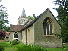 St Peter and St Paul's Church | |
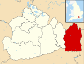
 Nutfield Location within Surrey | |
| Area | 9.81 km2 (3.79 sq mi) |
| Population | 2,673 (Civil Parish 2011)[1] |
| • Density | 272/km2 (700/sq mi) |
| • London | 18 miles (29 km) |
| Civil parish |
|
| District |
|
| Shire county | |
| Region | |
| Country | England |
| Sovereign state | United Kingdom |
| Post town | REDHILL |
| Postcode district | RH1 |
| Dialling code | 01737 |
| Police | Surrey |
| Fire | Surrey |
| Ambulance | South East Coast |

Nutfield is a village and civil parish in the Tandridge District of Surrey, England. It lies in the Weald immediately south of the Greensand Ridge and has a railway station at South Nutfield which is one stop from Redhill, on the Redhill to Tonbridge Line. It includes a watersports park and picnic destination, Mercers Country Park.
History[]
The village lay within the Reigate hundred.
Nutfield appears in Domesday Book of 1086 as Notfelle. It was held by Countess Ida of Boulogne (2nd wife of Count Eustace). Its domesday assets were: 3 hides; 1 church, 16 ploughs, 1 mill worth 2s, 10 acres (40,000 m2) of meadow, herbage worth 12 hogs. It rendered £15 per year to its feudal overlords.[2]
At the end of the 12th century, Nutfield was held by Hubert de Anstey and his wife Dionysia, then in 1210 it passed to his son and heir Nicholas de Anstey.[3]
The Grade II* listed St Peter and St Paul's church was built in the 13th century. The tower dates from the early 15th century but was partly rebuilt in the late 18th century.[4] There are two stained glass windows by Edward Burne-Jones.[5]
The Grade II listed Nutfield Priory is to the west of the village centre, constructed by John Gibson between 1872-4.[6]
Localities[]
Nutfield Marsh is the neighbourhood north of the winding and hilly, motorway-bypassed, east-west route, the A25, where the village centre is, which, including Nutfield Court and its conservation area, is outsized by the largest part of the community South Nutfield next to the nearest station, Nutfield railway station.
Governance[]
There is one representative on Surrey County Council, Conservative Rose Thorn, for a division co-serving Godstone and small villages around it.[7]
There are three representatives on Tandridge District Council:
| Member Since | Member[8] | Ward | |
|---|---|---|---|
| 2007 | Gill Black | Bletchingley & Nutfield | |
| 2006 | Tony Edouard Elias | ||
| 2021 | Liam Hammond | ||
The parish council has 8 members.[9]
The parish council was set up in 1894 under the terms of the Local Government Act 1894. The council's work ranges from planning applications, allotments, cemetery, meeting and cultural venues, overgrown footpaths to dog fouling. The Metropolitan Green Belt has been used to retain the largely agricultural green belt around the village.
Transport[]
At just over a mile, an undulating walk away, is Nutfield railway station in South Nutfield.
The A23 has road junctions to the village in Redhill and Salfords to the west, each 2 miles (3.2 km) away.
Amenities[]
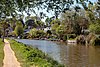
Within the bounds of Nutfield is the Aqua Sports Company's Mercers Park country park.
Famous Inhabitants[]
- Maria Louisa Charlesworth, popular author of religious books for children in the 1800s, lived at Church Hill House, Nutfield, and at The Cottage, where she died in 1861. She was buried at St Peter & St Paul's Church.
- Michael Maw (1912–1944), cricketer and Royal Air Force airman
Demography and housing[]
| Output area | Detached | Semi-detached | Terraced | Flats and apartments | Caravans/temporary/mobile homes | shared between households[1] |
|---|---|---|---|---|---|---|
| (Civil Parish) | 371 | 305 | 254 | 147 | 1 | 0 |
The average level of accommodation in the region composed of detached houses was 28%, the average that was apartments was 22.6%.
| Output area | Population | Households | % Owned outright | % Owned with a loan | hectares[1] |
|---|---|---|---|---|---|
| (Civil Parish) | 2,673 | 1,078 | 35.5% | 41.2% | 981 |
The proportion of households in the civil parish who owned their home outright compares to the regional average of 35.1%. The proportion who owned their home with a loan compares to the regional average of 32.5%. The remaining % is made up of rented dwellings (plus a negligible % of households living rent-free).
Nearest settlements[]
| show Nearest settlements |
|---|
See also[]
- List of places of worship in Tandridge (district)
References[]
- ^ Jump up to: a b c Key Statistics; Quick Statistics: Population Density Archived 11 February 2003 at the Wayback Machine United Kingdom Census 2011 Office for National Statistics Retrieved 21 November 2013
- ^ Surrey Domesday Book Archived 2007-07-15 at the Wayback Machine
- ^ Anstey, G.M. and T.J. (2017). ANSTEY: Our True Surname Origin and Shared Medieval Ancestry. p. 126.
- ^ "History". Nutfield Parish Church. Archived from the original on 14 July 2019. Retrieved 14 July 2019.
- ^ Historic England. "Details from listed building database (1377573)". National Heritage List for England. Retrieved 28 April 2012.
- ^ Historic England. "Nutfield Priory, Nutfield (1400998)". National Heritage List for England. Retrieved 29 September 2019.
- ^ "List of Surrey CC Councillors". Surrey County Council. Archived from the original on 3 May 2012. Retrieved 28 April 2012.
- ^ . Tandridge District Council. Retrieved 27 July 2021.
- ^ "Parish Council Members". Nutfield Parish Council. Archived from the original on 30 April 2012. Retrieved 28 April 2012.
| Wikimedia Commons has media related to Nutfield, Surrey. |
| show Authority control |
|---|
- Tandridge
- Civil parishes in Surrey
- Villages in Surrey