Asir Mountains
| Asir Mountains | |
|---|---|
 Jabal Sawdah ("Mount Sawdah") | |
| Highest point | |
| Coordinates | 21°36′N 39°48′E / 21.6°N 39.8°ECoordinates: 21°36′N 39°48′E / 21.6°N 39.8°E |
| Naming | |
| Native name | جِبَال ٱلْعَسِيْر (in Arabic) |
| Geography | |
 Asir Mountains | |
| Country | |

The Asir Mountains[1] (Arabic: جِبَال ٱلْعَسِيْر, jibāl al-ʿasyr; Arabic pronunciation: [ʕsiːr] ('Difficult')) is a mountainous region in southwestern Saudi Arabia running parallel to the Red Sea. It comprises areas in the Asir Region of Saudi Arabia, however it also generally includes areas near the Yemeni border. The mountains cover approximately 100,000 square kilometres (40,000 sq mi) and consists of mountains, plains, and valleys of the Arabian highlands.[2] Sensu lato, they are part of the Sarawat Mountains,[3] defining the latter as the mountain range which runs parallel to the Tihamah throughout the western portion of the Arabian Peninsula, particularly the western parts of Saudi Arabia and Yemen.[4][5][6]
Geology[]

The mountains consist primarily of sedimentary rock, limestone, sandstone and shale, of Jurassic, Cretaceous and Paleogene origin on a Precambrian granitic basement.[2]
Climate and agriculture[]
The region has the highest average rainfall of Saudi Arabia[citation needed] due to largely seasonal rain. Average rainfall can range from 600 millimetres (24 in) to over 1,000 millimetres (39 in) per year, in wet regions. The eastern plains and plateaus receive much lower amounts, from 500 millimetres (20 in) to below 100 millimetres (3.9 in) per year.[2]
The region's crops, most of which are cultivated on steeply terraced mountainsides, include wheat, coffee, cotton, indigo, ginger, vegetables, and palms. The region also supports cattle, sheep, goats, and camels.[citation needed]
Biodiversity[]
The region's difficult terrain has helped preserve the region's unique biodiversity. Several new Myxomycetes fungi species have been discovered in the region, as have a variety of previously undiscovered plants.[7] Asir is also thought to be one of the last natural habitats of the Arabian leopard.[2][5][6]
Gallery[]
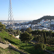
Abha city, located 2,270 m (7,450 ft) above sea level in the 'Asir Region

Habala Valley near Abha

Jabal Atherb, as seen from Ḥawālah in Bareq


See also[]
- Geography of Saudi Arabia
- List of mountains in Saudi Arabia
- Wildlife of Saudi Arabia
- Wildlife of Yemen
References[]
- ^ "Library of Congress Country Study: Saudi Arabia", The Library of Congress, archived from the original on 2008-09-23
- ^ Jump up to: a b c d "Southwestern Arabian montane woodlands". Terrestrial Ecoregions. World Wildlife Fund.
- ^ Overstreet, William Courtney (1977). Tertiary laterite of the As Sarat Mountains, Asir Province, Kingdom of Saudi Arabia. 2. Directorate General of Mineral Resources. pp. iii–2.
- ^ Nasr, Seyyed Hossein (2013). "1: The Holiest Cities of Islam". Mecca the Blessed, Medina the Radiant: The Holiest Cities of Islam. Tuttle Publishing. ISBN 978-1-4629-1365-7.
- ^ Jump up to: a b Judas, J.; Paillat, P.; Khoja, A.; Boug, A. (2006). "Status of the Arabian leopard in Saudi Arabia" (PDF). Cat News. Special Issue 1: 11–19.
- ^ Jump up to: a b Spalton, J. A. & Al-Hikmani, H. M. (2006). "The Leopard in the Arabian Peninsula – Distribution and Subspecies Status" (PDF). Cat News (Special Issue 1): 4–8.
- ^ Boulos, L. (1985), "Myxomycetes from the Asir Mountains, Saudi Arabia (abstract)", A contribution of the flora of the Asir Mountains, Saudi Arabia, 3, Arab Gulf Journal of Scientific Research, pp. 67–94, archived from the original on February 29, 2012
Further reading[]
| show Hills and mountains on the Arabian Peninsula |
|---|


| Authority control |
|
|---|
- Mountain ranges of Saudi Arabia
- 'Asir Province
- Southwestern Arabian foothills savanna