Atrax (Thessaly)
Coordinates: 39°34′12″N 22°11′30″E / 39.57005°N 22.19173°E

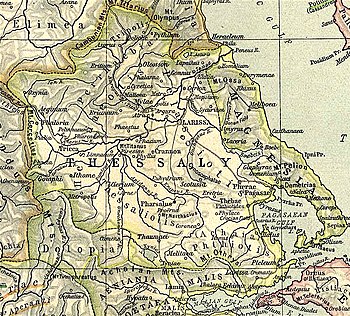
Atrax (Ancient Greek: Ἄτραξ, or Ἄτραγϕϛ[1] or Ἄτρακοϛ[2]) or Atracia (Ἀτρακία)[3][4] was a Perrhaebian town in ancient Thessaly, described by Livy as situated above the river Peneius, at the distance of about 10 miles (16 km) from Larissa.[5] Strabo says that the Peneius passed by the cities of Tricca, Pelinnaeum and Pharcadon, on its left, on its course to Atrax and Larissa.[6] The town is attested as Ἆδρακος in the nominative in a catalog of theorodokoi of Epidaurus,[7] dating from 363-359 BCE.[8] It was also a polis (city-state) in antiquity.[9]
History[]
The town was located in the district of Pelasgiotis and its territory was bordered on the north by Phalanna, the northeast by Argura, and to the south by Crannon.[3]
In the 5th century BCE, the acropolis and the slope of the hill were enclosed in a polygonal enclosure. In the 4th century BCE the acropolis was rebuilt: a quadrangular tower was built and fortified with a new wall with five towers, one of them with a fortified gate. The eastern part of the wall of the hill was reinforced in the 4th century BCE, And bears similarity to the defensive constructions of Halos.[10] The lower part was enclosed in the 4th century BCE by an opus isodomum wall with four quadrangular towers. It was 3 kilometres (1.9 mi) long and surrounded an area of 64 hectares (160 acres). The main gate was in the northwest, and was accessed by a polygonal stone ramp.[9]
During the food crisis of 330-326 BCE Atrax received 10,000 medimnoi of wheat from Cyrene, in Africa.[11]
Atrax minted silver and bronze coins at the beginning of the 4th century BCE, With the legends «ΑΤΡΑ», «ΑΤΡΑΓΙΟΝ», and «ΑΤΡΑΓΙΩΝ».[12]
Location[]
Modern scholars locate Atrax at a kastro called in the modern village of (Greek: Κουτσόχερο), in the municipal unit of Koilada, in the municipality of Larissa.[13][14]
References[]
- ^ Supplementum Epigraphicum Graecum 34.560.3 c. 450 BCE)
- ^ Strabo. Geographica. 9.5.20. Page numbers refer to those of Isaac Casaubon's edition.
- ^ Jump up to: a b Stephanus of Byzantium. Ethnica. s.v.
- ^ Ptolemy. The Geography. 3.13.42.
- ^ Livy. Ab Urbe Condita Libri (History of Rome). 32.15, 36.13.
- ^ Strabo. Geographica. ix. p.438. Page numbers refer to those of Isaac Casaubon's edition.
- ^ IG iv2.1 94.b.3.
- ^ Perlman, P. (2000). City and Sanctuary in Ancient Greece. The Theorodokia in the Peloponnese, Hypomnemata 121. Göttingen, p. 178 E.1b3
- ^ Jump up to: a b Mogens Herman Hansen & Thomas Heine Nielsen (2004). "Thessaly and Adjacent Regions". An inventory of archaic and classical poleis. New York: Oxford University Press. p. 692. ISBN 0-19-814099-1.
- ^ H. Reinder Reinders (1988). Hew Halos: A Hellenistic Town in Thessalia, Greece. p. 54.
- ^ Tod, M. N. (1933-1948). A Selection of Greek Historical Inscriptions, I-II. Oxford. 196.24 (330-326)
- ^ Rogers, E. (1932). The Copper Coinage of Thessaly, pp.159-168
- ^ Richard Talbert, Barrington Atlas of the Greek and Roman World, (ISBN 0-691-03169-X), Map 55.
- ^ Lund University. Digital Atlas of the Roman Empire.
This article about a location in ancient Thessaly is a stub. You can help Wikipedia by . |
- Populated places in ancient Thessaly
- Former populated places in Greece
- Pelasgiotis
- Larissa (regional unit)
- Perrhaebia
- Thessalian city-states
- Ancient Thessaly geography stubs