Auckland County
| Auckland New South Wales | |||||||||||||||
|---|---|---|---|---|---|---|---|---|---|---|---|---|---|---|---|
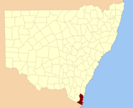 Location in New South Wales | |||||||||||||||
| |||||||||||||||
Auckland County is one of the 141 cadastral divisions of New South Wales. It is at the extreme south-east of the state, with the Victorian border to the south, and the area to the north of the Brogo River the boundary to the north. It includes Bega, Eden and Merimbula.
The county was named after George Eden, who was the First Earl of Auckland between (1784-1849).[1] In 1852, it had an area of 1,536,000 acres (6,220 km2) and was described as being mountainous with fertile plains.[2]
References[]
- ^ "Auckland County". Geographical Names Register (GNR) of NSW. Geographical Names Board of New South Wales.

- ^ "Old Welsh Books with English Translations", The Land of Gold: the Companion for the Welsh Emigrant to Australia, 1852
Categories:
- Counties of New South Wales