Augšdaugava
| Augšdaugava | |
|---|---|
IUCN category V (protected landscape/seascape) | |
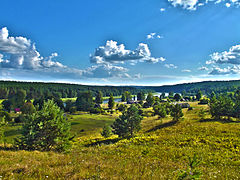 Daugava riverside at Slutiški | |
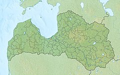 | |
| Location | Latvia, Latgale |
| Coordinates | 55°53′00″N 27°00′00″E / 55.88333°N 27.00000°ECoordinates: 55°53′00″N 27°00′00″E / 55.88333°N 27.00000°E |
| Area | 520.78 km2 (201.07 sq mi) [1] |
| Established | 1990 |
Augšdaugava is a protected landscape located in Latgale, Augšdaugava Municipality and Krāslava Municipality on the banks of the Daugava , as well as stretching to the side of in the north and Augšzeme in the south. Established in 1990 to preserve outstanding cultural and natural values in the Daugava Valley and its surroundings. The territory includes Nature Park and several protected nature objects: , (Slutišķi and Ververu Cliff), , , , , , , . [2] It is Natura 2000 area.[1]
References[]
| Wikimedia Commons has media related to Augšdaugava protected landscape area. |
- ^ a b Augšdaugava Protected Planet
- ^ Nature Protection Board. Augšdaugava
This Latgale location article is a stub. You can help Wikipedia by . |
This article related to a protected area in Europe is a stub. You can help Wikipedia by . |
Categories:
- IUCN Category V
- Natura 2000 in Latvia
- Nature parks in Latvia
- Augšdaugava Municipality
- Krāslava Municipality
- Latgale
- Latgale geography stubs
- European protected area stubs