Azewijn
Azewijn | |
|---|---|
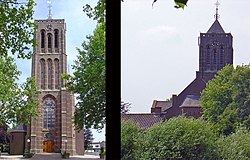 Mattheuskerk van Azewijn | |
 Azewijn Location in the Netherlands | |
| Coordinates: 51°53′8″N 6°18′15″E / 51.88556°N 6.30417°ECoordinates: 51°53′8″N 6°18′15″E / 51.88556°N 6.30417°E | |
| Country | Netherlands |
| Province | Gelderland |
| Municipality | Montferland |
| Area | |
| • Total | 12.96 km2 (5.00 sq mi) |
| Elevation | 15 m (49 ft) |
| Population (2021)[1] | |
| • Total | 910 |
| • Density | 70/km2 (180/sq mi) |
| Time zone | UTC+1 (CET) |
| • Summer (DST) | UTC+2 (CEST) |
| Postal code | 7045[1] |
| Dialing code | 0314 |


Azewijn is a village in the Dutch province of Gelderland. It is in the municipality Montferland, about 3 km east of the town of 's-Heerenberg.
The main part of the village is also known as "Groot-Azewijn" (Greater Azewijn), in contrast with the hamlet "Klein-Azewijn" (Lesser Azewijn) about 1 km to the north.[3]
History[]
It was first mentioned in 1025 as Asawon. The etymology is unclear.[4] There was a little castle near Azewijn which used to terrorise its environment. It used to belong to the Kingdom of Prussia, and became part of the Netherlands in 1816.[5] In 1840, it was home to 525 people.[3] In 1891, the St Matthews Church was built in Azewijn. On 31 March 1945, it was burned by the Germans. It was rebuilt in 1950–1951.[3]
Images[]

Laakweg
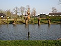
De Laak

Gendringseweg 3
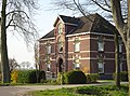
Gendringseweg 5


References[]
- ^ a b c "Kerncijfers wijken en buurten 2021". Central Bureau of Statistics. Retrieved 23 March 2022.
two entries
- ^ "Postcodetool for 7045AA". Actueel Hoogtebestand Nederland (in Dutch). Het Waterschapshuis. Retrieved 23 March 2022.
- ^ a b c "Azewijn". Plaatsengids (in Dutch). Retrieved 23 March 2022.
- ^ "Azewijn - (geografische naam)". Etymologiebank (in Dutch). Retrieved 23 March 2022.
- ^ "Azewijn, als vroegste vermelding van Berghse buurtschap in de geschreven bronnen". Heemkundekring Bergh (in Dutch). Retrieved 23 March 2022.
| Wikimedia Commons has media related to Azewijn. |
This Gelderland location article is a stub. You can help Wikipedia by . |
- Populated places in Gelderland
- Montferland
- Gelderland geography stubs