Bóly
Bóly
Bohl (in German) | |
|---|---|
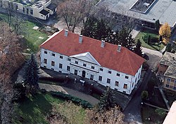 Palace | |
 Flag  Coat of arms | |
 Bóly Location of Bóly | |
| Coordinates: 45°58′02″N 18°31′06″E / 45.96729°N 18.51825°ECoordinates: 45°58′02″N 18°31′06″E / 45.96729°N 18.51825°E | |
| Country | |
| County | Baranya |
| District | Bóly |
| Area | |
| • Total | 25.34 km2 (9.78 sq mi) |
| Population (2015)[1] | |
| • Total | 3,887 |
| • Density | 150/km2 (400/sq mi) |
| Time zone | UTC+1 (CET) |
| • Summer (DST) | UTC+2 (CEST) |
| Postal code | 7754 |
| Area code | (+36) 69 |
| Website | telepules |

Bóly (Croatian: Boja, German: Bohl) is a town in Baranya county, Hungary.
Twin towns – sister cities[]
Bóly is twinned with:
 Semriach, Austria
 Heroldsberg, Germany
 Cernat, Romania
 Neded, Slovakia
Sports[]
The local sports team is called .
References[]
- ^ Gazetteer of Hungary, 1 January 2015. Hungarian Central Statistical Office.
External links[]
| Wikimedia Commons has media related to Bóly. |
- Official website in Hungarian, English and German
| show Baranya County |
|---|


| show Authority control |
|---|
This Baranya County–related article is a stub. You can help Wikipedia by . |
Categories:
- Populated places in Baranya County
- Hungarian German communities
- Baranya County geography stubs