Baranyajenő
Baranyajenő | |
|---|---|
Village | |
 | |
 Seal | |
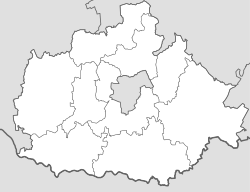 Baranyajenő Location in Baranya County | |
| Coordinates: 46°16′15″N 18°02′41���E / 46.27083°N 18.04472°ECoordinates: 46°16′15″N 18°02′41″E / 46.27083°N 18.04472°E | |
| Country | |
| County | Baranya |
| District | Hegyhát |
| Government | |
| • Type | Mayor-council |
| • Mayor | Csaba Balogh (Ind.) |
| Area | |
| • Total | 15.55 km2 (6.00 sq mi) |
| Population (2021)[3] | |
| • Total | 424 |
| • Density | 27/km2 (71/sq mi) |
| Time zone | UTC+1 (CET) |
| • Summer (DST) | UTC+2 (CEST) |
| Postal code | 7384 |
| Area code | 72 |
| NUTS 3 | HU231 |
| HCSO | 24749 |
| Website | www.baranyajeno.asp.lgov.hu |


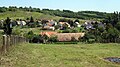
Baranyajenő ([ˈbɒrɒɲɒjɛnøː], German: Jening) is a village (Hungarian: község) in Hegyhát District, northern Baranya county, in the Southern Transdanubia region of Hungary. Its population at the was 455.[4]
Geography[]
The village is located at 46° 16′ 15″ N, 18° 2′ 41″ E. Its area is 15.55 km2 (6.00 sq mi). It is part of the Southern Transdanubia statistical region, and administratively it falls under Baranya County and Hegyhát District. It lies 5 km (3.1 mi) north of the village of Mindszentgodisa and 26.5 km (16.5 mi) northwest of Pécs.[5]
Demographics[]
2011 census[]
As of the , there were 455 residents, 154 households, and 114 families living in the village. The population density was 76 inhabitants per square mile (29/km2). There were 159 dwellings at an average density of 27 per square mile (10/km2). The average household size was 2.87. The average number of children was 1.37. The average family size was 3.13.[4]
Religious affiliation was 81.2% Roman Catholic, 2.0% Calvinist, 0.7% Lutheran, and 0.7% other religion, with 15.4% declining to answer.
The village had a significant ethnic minority Roma population of 40.3%. A small number of residents also identified as German (2.5%), Romanian (0.2%) and Serb (0.2%). The vast majority declared themselves as Hungarian (96.6%), with 3.4% declining to answer.[note 1][3]
Local government[]
The village is governed by a mayor with a four-person council. The local government of the village operates a with the nearby localities of Bakóca, Kisbeszterce, Kishajmás, Mindszentgodisa, Szágy, and Tormás. The seat of the joint council is in Mindszentgodisa.[2][3]
As of the election of 2019, the village also has a local for its Roma community, with three elected representatives.[6]
Transportation[]
Railway[]
- , 6 km (3.7 mi) east of the village. The station is on the and railway lines and is operated by MÁV.[3]
Gallery[]
Baranyajenő

Graveyard of Baranyajenő

Town sign of Baranyajenő

Fast food restaurant in Baranyajenő

Entrance to the graveyard of Baranyajenő

Old town sign of Baranyajenő

Church in Baranyajenő


External links[]
Notes[]
- ^ As a person can affiliate themselves with more than one ethnic group (nationality), the totals may be greater than 100%.
References[]
- ^ "Local government elections 2019". . Retrieved 24 October 2021.
- ^ a b "Gazetteer of Hungary, 1 January 2019" (PDF). Hungarian Central Statistical Office (in Hungarian). Retrieved 24 October 2021.
- ^ a b c d "Detailed Gazetteer of Hungary". Hungarian Central Statistical Office. Retrieved 24 October 2021.
- ^ a b "Population Census 2011: Regional Data - Baranya County". Hungarian Central Statistical Office. 1 October 2011. Archived from the original on 2013-09-03. Retrieved 24 October 2021.
- ^ "Distance Calculator Find Distance Between Cities". Distance Calculator. Retrieved 2021-10-24.
- ^ "Ethnic municipal elections 2019". . Retrieved 24 October 2021.
| Towns (2) | ||
|---|---|---|
| Villages (23) | ||


This Baranya County–related article is a stub. You can help Wikipedia by . |
- Populated places in Baranya County
- Baranya County geography stubs