Babia Góra National Park
| Babia Góra National Park | |
|---|---|
| Babiogórski Park Narodowy | |
 | |
| Location | Lesser Poland Voivodeship, Poland |
| Area | 33.92 km2 (13.10 sq mi) |
| Established | 1954 |
| Governing body | Ministry of the Environment |
Babia Góra National Park (Polish: Babiogórski Park Narodowy) is one of the 23 national parks in Poland, located in the southern part of the country, in Lesser Poland Voivodeship, on the border with Slovakia. The Park has its headquarters in the village of Zawoja.
The park covers an area of 33.92 square kilometres (13.10 sq mi), of which forests occupy 31.98 km2 (12.35 sq mi). The park includes the northern and part of the southern side of the Babia Góra massif, of which the main peak (also known as Diablak) is the highest point of the Orava Beskids mountain range at 1,725 metres (5,659 ft). There is a protected area Horná Orava Protected Landscape Area on the Slovak side of the massif.
The area of Babia Góra was first brought under legal protection in 1933, when the Babia Góra Reserve was created. On October 30, 1954 it was designated a National Park. Since 1976 it has been listed by UNESCO as a biosphere reserve under the Man and the Biosphere (MaB) programme. The area of the biosphere reserve was extended in 2001.
Fauna[]
- 105 species of birds (including woodpeckers and eagle owls)
- Animals such as deer, lynx, wolves and bears
- Insects, especially beetles, including some that are unique to the area
Gallery[]
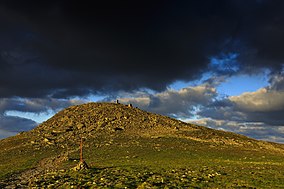
Babia Gora (1725 m), the highest peak of the national park

Summit of Babia Góra

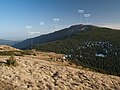
Babia Góra seen from Mosorny Groń

A forest in the Babia Góra National Park

A mountain trail

Beskid Żywiecki landscape

Babia Góra and Pilsko seen from Rysianka

Campanula polymorpha

Ostoja Babiogórska Nature Reserve with Alpine flora
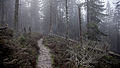
A forest trail
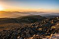
Sunset over Ostoja Babiogorska


External links[]
| Wikimedia Commons has media related to Babia Góra. |
- "Official site" (in Polish). Retrieved 6 November 2011.
- "The Board of Polish National Parks" (in Polish). Archived from the original on 2006-02-25. Retrieved 6 November 2011.
- "UNESCO biosphere reserve information". Retrieved 6 November 2011.
Coordinates: 49°35′18.05″N 19°32′22.92″E / 49.5883472°N 19.5397000°E

- IUCN Category II
- Parks in Lesser Poland Voivodeship
- National parks of Poland
- Biosphere reserves of Poland
- Protected areas established in 1954
- Protected areas of the Western Carpathians
- 1954 establishments in Poland