Tatra National Park, Poland
| Tatra National Park | |
|---|---|
| Tatrzański Park Narodowy | |
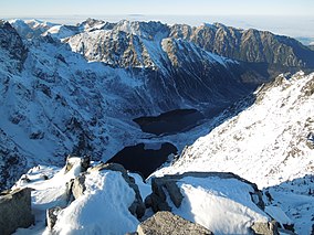 Mountain lakes of Czarny Staw pod Rysami and Morskie Oko seen from Poland's highest point, the north-western summit of Rysy, 2,499 metres (8,199 ft) in elevation.
| |
 Location in Poland | |
| Location | Tatra Mountains, southern Poland |
| Nearest city | Zakopane |
| Coordinates | 49°10′N 19°55′E / 49.167°N 19.917°ECoordinates: 49°10′N 19°55′E / 49.167°N 19.917°E |
| Area | 211.64 km² (81.71 mi²) |
| Established | 1954 |
| Governing body | Ministry of the Environment |
| Official name | Glacial lakes in the Tatra National Park |
| Designated | 11 December 2017 |
| Reference no. | 2340[1] |
| Official name | Peat bogs in the Tatra National Park |
| Designated | 11 December 2017 |
| Reference no. | 2341[2] |

Tatra National Park (Polish: Tatrzański Park Narodowy; abbr. TPN) is a National Park located in the Tatra Mountains in Tatra County, in the Lesser Poland Voivodeship—Małopolska region, in central-southern Poland.[3] The Park has its headquarters in the town of Zakopane.
The Tatra Mountains form a natural border between Poland to the north and Slovakia to the south, and the two countries have cooperated since the early 20th century on efforts to protect the area. Slovakia created an adjoining national park, and UNESCO later designated the combined effort a transboundary biosphere reserve.
Park history[]
The first calls for protection of the Tatras came at the end of the 19th century. In 1925 the first efforts to create a national park, in cooperation with Slovakia, took place. Formally the park was created in 1937, on an area that belonged to the state forests authority. In 1947, a separate administrative unit, Tatra Park, was created.
In 1954, by decision of the Polish Government, Tatra National Park was created. It was established originally with an area of 215.56 km2 (83.23 sq mi), but it is currently slightly smaller, at 211.64 km2 (81.71 sq mi). Of this, 151.91 km2 (58.65 sq mi) is forest and the remainder mainly meadows. Strictly protected zones account for 115.14 km2 (44.46 sq mi), of which 61.49 km2 (23.74 sq mi) are forest ecosystems.
In 1992, the Polish and Slovakian national parks in the Tatras were jointly designated a transboundary biosphere reserve by UNESCO, under its Man and the Biosphere Programme.[4]
Geography[]
- Mountains
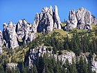
The National Park covers one of the two Alpine mountain ranges in Poland. The Polish Tatra range, which is a part of the Western Carpathian Mountains, is divided into two sections: the High Tatras (Tatry Wysokie) and the Western Tatras (Tatry Zachodnie). The landscape consists of sharp-edged peaks and hollows with numerous rock formations.[3] The highest peak in Poland, Rysy (2,499 metres (8,199 ft) AMSL), is located here.
- Caves
There are around 650 caves in the park, of which the Wielka Sniezna cave system is the longest (18 kilometres (11 mi)), and the deepest (maximum depth 814 metres (2,671 ft)). Six caves of this system are open to public.
- Water
There are several streams, the longest stream reaching 20 kilometres (12 mi). Waterfalls, such as Wodogrzmoty Mickiewicza are popular with tourists. The highest waterfall is Wielka Siklawa at 70 metres (230 ft)).
The park has over 30 mountain lakes, called staw (Polish: pond). These water bodies are an important part of the High Tatra landscape. The largest lakes are: Morskie Oko with an area of 349,000 m² and maximum depth of 50.8 metres (167 ft)); and Wielki Staw with an area of 344,000 m² and maximum depth of 79.3 metres (260 ft)).
Biology and ecology[]


Flora[]
Up to 1,250 metres (4,100 ft) there are mainly Silver fir (Abies alba) and European beech (Fagus sylvatica) forests. Higher levels, up to 1,550 metres (5,090 ft), are covered with European spruce (Picea abies) forests, which turn into meadows and grasslands at higher elevations up to 1,800 metres (5,900 ft). The highest elevations, above 1,800 metres (5,900 ft), have alpine flora habitats.
Other typical species include Swiss pine (Pinus cembra), Edelweiss (Leontopodium alpinum), and Stemless carline thistle (Carlina acaulis). Spring in the Kościeliska Valley is notable for the fields of Giant crocus (Crocus vernus, syn: Crocus scepusiensis).
Fauna[]
The National Park contains several endemic fauna species, and many endangered and protected ones. Animals include: the Tatra chamois and marmot, both protected since the mid-19th century; brown bear, Eurasian lynx, gray wolf, European otter, lesser spotted eagle, and falcon.
Culture[]
The Górale[]
The Podhale region of the Tatras is home to the Górales or the Goral (highland) people. Distinctive elements of their culture include the Podhale dialect (language), music, and traditional artisan customs such as clothes, wooden vernacular architecture, cheesemaking, and craft works.[5][3] The historic Górale culture was traditionally passed on in oral stories.
Environment[]
The area of the Tatra mountains was exploited by human activities in the past. During summer numerous herds of animals (such as goats, sheep, and cows) pastured on the meadows and these practices caused erosion processes. In the 18th and 19th centuries several mines and ironworks were built here, industries that used substantial harvests of local timber.
Current environmental threats include: the proximity of the fast-developing town of Zakopane; and air pollution from the industrial zones in Kraków, Ostrava, and Orava. Fauna is threatened by poachers and habitat loss.
The high number of tourists is the largest threat to Park’s ecosystem currently. Also, the infrastructure, such as hotels and car parks, is not sufficient for the current volume of visitors.[citation needed]
Tourism[]
Tourism was first developed in the Tatras in the late 19th century, and continues in the 21st. It is the most visited of the national parks in Poland.[3]
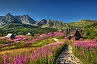
There are more than 270 kilometres (170 mi) of hiking trails in Tatra National Park.[3]
Gallery[]
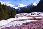
A field of crocuses in the Goryczkowa Valley, Western Tatras
Mnichy Chochołowskie

Siklawa waterfall
Hala Gąsienicowa

Czarny Staw pod Rysami and Morskie Oko lakes

Snow covered Tatras in May 2019

Chochołowska Valley in winter
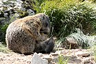
Tatra Marmots

European brown bear


See also[]
- Tatra National Park, Slovakia — biosphere reserve partner.
- Western Carpathians Ranges
- List of national parks of Poland
References[]
- ^ "Glacial lakes in the Tatra National Park". Ramsar Sites Information Service. Retrieved 25 April 2018.
- ^ "Peat bogs in the Tatra National Park". Ramsar Sites Information Service. Retrieved 25 April 2018.
- ^ Jump up to: a b c d e en.poland.gov: Tatra National Park . accessed 5.12.2013
- ^ "Europe & North America: 297 biosphere reserves in 36 countries". Ecological Sciences for Sustainable Development. Archived from the original on 2015-08-05. Retrieved 2016-01-31.
- ^ National Geographic Magazine; "The Górale People"; c. 1980s issue; pp 105 - 130.
External links[]
| Wikimedia Commons has media related to Tatra National Park. |
- Official Tatra National Park website — (English)
| Authority control: National libraries |
|---|
- IUCN Category II
- National parks of Poland
- Biosphere reserves of Poland
- Parks in Lesser Poland Voivodeship
- Protected areas of the Western Carpathians
- Protected areas established in 1954
- Tatra County
- High Tatras
- Western Tatras
- Tatra Mountains
- 1954 establishments in Poland
- Ramsar sites in Poland