Rysy
| Rysy | |
|---|---|
 Main summit | |
| Highest point | |
| Elevation | 2,501 m (8,205 ft)[1] |
| Prominence | 161 m (528 ft)[2] |
| Isolation | 0.87 km (0.54 mi) |
| Listing | Country high point (Poland) |
| Coordinates | 49°10′46″N 20°5′17″E / 49.17944°N 20.08806°ECoordinates: 49°10′46″N 20°5′17″E / 49.17944°N 20.08806°E[2] |
| Naming | |
| English translation | scratches or crevices |
| Language of name | Polish and Slovak |
| Geography | |
 Rysy Location in Lesser Poland Voivodeship | |
| Location | Poland / Slovakia |
| Parent range | High Tatras |
| Geology | |
| Mountain type | Granite |
| Climbing | |
| First ascent | 1840 by Ede Blásy, Ján Ruman-Driečny[citation needed] |
| Easiest route | Hiking |


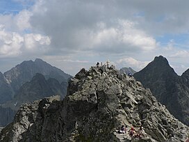
Rysy (Polish: [ˈrɨsɨ]; Slovak: [ˈrisi]; German: Meeraugspitze, Hungarian: Tengerszem-csúcs) is a mountain in the crest of the High Tatras, eastern part of the Tatra Mountains, lying on the border between Poland and Slovakia. Rysy has three summits: the middle at 2,501 m (8,205 ft); the north-western at 2,500 m (8,202 ft); and the south-eastern at 2,473 m (8,114 ft). The north-western summit is the highest point of Poland and belongs to the Crown of Polish Mountains; the other two summits are on the Slovak side of the border.
Name[]
Experts assume that the Polish and Slovak name Rysy, meaning "scratches" or "crevices", refers to a series of couloirs, either those on the western slopes of Żabie Ridge or the very prominent 500 m (1,600 ft) high couloir and numerous smaller on the northern side. A folk explanation on the Slovak side says that the name comes from the plural word rysy meaning "lynxes", although the habitat of the lynx does not extend above the timberline.
The Hungarian name Tengerszem-csúcs and the German name Meeraugspitze mean "eye-of-the-sea peak", from the glacial lake at the northern foot of the mountain, called "eye of the sea" (Morskie Oko in Polish).
History[]
The first known ascent was made in 1840, by Ede Blásy and his guide Ján Ruman-Driečny, Sr. The first winter ascent was completed in 1884, by Theodor Wundt and Jakob Horvay.
Rysy at present is the highest point in Poland, earlier however, the highest peak of Poland was Zadni Gerlach (2616 m).
Tourism[]
Rysy is the highest peak in the Tatra Mountains that is accessible to individual tourists on foot without a mountain guide. It is possible to ascend the peak from the Slovak side, starting at Štrbské pleso and passing Chata pod Rysmi, a mountain chalet at an altitude of 2,250 m (7,380 ft), open during the summer season (from June 15 to October 31). The mountain can also be ascended from the Polish side coming from the Morskie Oko lake, which is a more spectacular route, but at the same time more difficult and more exposure.
Between November 1 and June 15, the trail on the Slovak side is closed.
The winter ascent from the Polish side is a serious climb requiring the right equipment (crampons, ice axe) and skills, often with a large avalanche threat. There have been serious avalanche events, including fatal ones. The average slope of the slope above the Czarny Staw is around 30 degrees. In the Rysa couloir, about 40 degrees to its half. In the upper part, the incline reaches up to 44 degrees.
Since the accession of Poland and Slovakia to the Schengen Agreement in 2007, the border between the two countries may be easily crossed at this point like at any other.
See also[]
- Orla Perć
- Giewont
- Tourism in Poland
- Tourism in Slovakia
- Geography of Poland
- Geography of Slovakia
- Tatra Volunteer Search and Rescue (Poland)
- Mountain Rescue Service (Slovakia)
- List of highest paved roads in Europe
- List of mountain passes
References[]
- ^ Nowe ustalenia dotyczące wysokości szczytów w Tatrach
- ^ Jump up to: a b "Rysy". Peakbagger.com. Retrieved 2019-04-05.
External links[]
| Wikimedia Commons has media related to Rysy. |
- TOPR - Polish Tatra Mountain Rescue Service
- Additional photos
- Rysy at Peakbagger.com
- Chalet below the Rysy peak
- Additional information including some photos
3D Panorama[]
- Two-thousanders of Poland
- Two-thousanders of Slovakia
- Mountains of the Western Carpathians
- Poland–Slovakia border
- International mountains of Europe
- High Tatras
- Highest points of countries