Hoverla
| Hoverla | |
|---|---|
| Говерла | |
 Hoverla, September 2003 | |
| Highest point | |
| Elevation | 2,061 m (6,762 ft)[1] |
| Prominence | 721 m (2,365 ft)[1] |
| Listing | Country high point |
| Coordinates | 48°09′36″N 24°30′01″E / 48.16000°N 24.50028°ECoordinates: 48°09′36″N 24°30′01″E / 48.16000°N 24.50028°E[1] |
| Geography | |
 Hoverla Ukraine | |
| Location | West Ukraine, Ukraine |
| Parent range | Chornohora (Carpathians) |


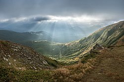
Mount Hoverla (Ukrainian: Говерла, Hoverla; Russian: Говерла, Goverla; Rusyn: Говерла, Hoverla; Hungarian: Hóvár; Romanian: Hovârla; Goverla, Polish: Howerla), at 2,061 metres (6,762 ft), is the highest mountain in Ukraine and part of the Carpathian Mountains. The mountain is located in the Eastern Beskids, in the Chornohora region. The slopes are covered with beech and spruce forests, above which there is a belt of sub-alpine meadows called polonyna in Ukrainian. At the eastern slope there is the main spring of the Prut River. The name is of Hungarian origin and means 'snow fortress'. Hoverla is composed of sandstone, a sedimentary rock type.

The date of the first ascent is unknown. In late 19th century the mountain became a notable tourist attraction, especially among tourists from nearby cities of Galicia. In 1880 the first tourist route between the peak of Hoverla and Krasny Luh was marked by of the Galician Tatra Society. The following year the first tourist shelter was founded there.
In the 20th century the mountain increasingly gained popularity as an extreme sports site. Some routes are classified as 1A in the winter period (from late autumn to May), according to the Soviet grading system. Nowadays because of its prominence too many unskilled extreme-lovers are taking attempts to climb it in winter, resulting in regular frostbite or even deaths. The most popular approach to the summit starts from the tour-basa Zaroslyak on the mountain's east face and gains more than 3,600 vertical feet (1,100 meters) along a steep path with few switchbacks. There is a steeper route (marked with blue signs) and a more gentle one but a lengthier one (marked with green).
In October 2007 the far right pro-Russian Eurasia Party-affiliated Eurasian Youth Union vandalized the official Ukrainian state symbols that had been placed on the summit of Hoverla.[2]
See also[]
References[]
- ^ Jump up to: a b c Hoverla, "Gora Goverla, Ukraine" on Peakbagger.com Retrieved 29 September 2011
- ^ Eurasian Youth Union outraged state symbols of Ukraine (photo), UNIAN News Agency, October 22, 2007
External links[]
| Wikimedia Commons has media related to Hoverla. |
- Hoverla climb on youtube
- Hoverla Guided Tour
- Info, advice and equipment lists on winter Hoverla ascents (in Ukrainian)
- Hoverla – photographs and information in Czech
- Extreme winter sports on Hoverla
| show Authority control |
|---|
- Mountains of Ukraine
- Mountains of the Eastern Carpathians
- Highest points of countries
- Two-thousanders of Ukraine