Gaiziņkalns
This article needs additional citations for verification. (April 2014) |
| Gaiziņkalns | |
|---|---|
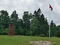 A flagpole with a replica of the demolished tower. | |
| Highest point | |
| Elevation | 312 m (1,024 ft) |
| Prominence | 187 m (614 ft) |
| Isolation | 114.91 km (71.40 mi) to Suur Munamägi |
| Listing | Country high point |
| Coordinates | 56°52′12.93″N 25°57′33.68″E / 56.8702583°N 25.9593556°ECoordinates: 56°52′12.93″N 25°57′33.68″E / 56.8702583°N 25.9593556°E |
| Geography | |
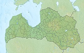 Gaiziņkalns Location of in Latvia | |
| Location | Bērzaune parish, Madona Municipality, Latvia |

The Gaising or Gaiziņkalns (German: Mesenberg), at 312 m (1,024 feet[1]) above sea level, is the highest point in Latvia. It is situated in the Vidzeme Upland a short distance to the west of the town of Madona, central Vidzeme.
Although only relatively low, Gaiziņkalns has been developed into a skiing area with three slopes and several guesthouses.[2] In order to rival Suur Munamägi - the highest point of neighbouring Estonia at 318 metres - a tower was built which exceeds the latter in height. Although the construction work was not finished, the tower became a popular tourist attraction, which led to its closure due to the serious risk to safety. The tower was demolished in December 2012, and the rubble removed. There is a nearby multilingual sign marking the high point, but nothing at the natural summit itself.

See also[]
- Extreme points of Latvia
- List of highest points of European countries
References[]
- ^ Gaiziņkalna augstuma precizēšana Archived 2016-11-24 at the Wayback Machine Latvijas Ģeotelpiskās informācijas aģentūra
- ^ Madonas novads. "Golgata Recreation Center (Gaiziņkalns)". Retrieved April 12, 2014.
External links[]
This Vidzeme location article is a stub. You can help Wikipedia by . |
- Extreme points of Latvia
- Highest points of countries
- Madona Municipality
- Vidzeme geography stubs