Suur Munamägi
This article does not cite any sources. (February 2022) |
| Suur Munamägi | |
|---|---|
 Suur Munamägi seen from north-east | |
| Highest point | |
| Elevation | 318 m (1,043 ft) European Vertical Reference System |
| Prominence | 218 m (715 ft) |
| Isolation | 169.93 km (105.59 mi) |
| Listing | Country high point |
| Coordinates | 57°42′52″N 27°03′33″E / 57.71444°N 27.05917°ECoordinates: 57°42′52″N 27°03′33″E / 57.71444°N 27.05917°E |
| Geography | |
 Suur Munamägi Estonia | |
| Location | Haanja, Võru County, Estonia |

Suur Munamägi (Estonian pronunciation: [ˈsuːr ˈmunɑmæɡ̊i]; translation "Great Egg Mountain") is the highest peak in Estonia (and the Baltic states), reaching 318 metres (1,043 ft) above sea level. It is located near the village of Haanja, in Võru County in the south-eastern corner of Estonia, close to the borders of both Latvia and Russia. The landscape around the peak - the Haanja Upland - is gently hilly.

Mount Suur Munamägi in Southern Estonia
History[]

Suur Munamagi in Southern Estonia
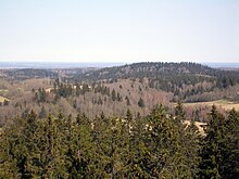
Hilly and forested landscape around Suur Munamägi

Suur Munamägi Tower
See also[]
External links[]
| Wikimedia Commons has media related to Suur Munamägi. |
Categories:
- Hills of Estonia
- Rõuge Parish
- Landforms of Võru County
- Tourist attractions in Võru County
- Highest points of countries