Slættaratindur
| Slættaratindur | |
|---|---|
 | |
| Highest point | |
| Elevation | 880 m (2,890 ft) |
| Prominence | 880 m (2,890 ft) |
| Coordinates | 62°17′47″N 7°00′45″W / 62.29639°N 7.01250°WCoordinates: 62°17′47″N 7°00′45″W / 62.29639°N 7.01250°W |
| Geography | |
 Slættaratindur Location of Slættaratindur in the Faroe Islands | |
| Location | Eysturoy, Faroe Islands |

Slættaratindur (English: Flat peak) is the highest mountain in the Faroe Islands, at an elevation of 880 metres.[1] It is located in the northern part of Eysturoy, between the villages of Eiði, Gjógv, and Funningur. Funningur lies at the foot of the mountain, however, the summit is not visible from the village.
Its name means "flat summit". It can be climbed in about four hours, and although the routes are steep, technical climbing skills are not necessary to reach the summit. In clear weather, the summit gives views over the entire archipelago. Slættaratindur is one of ten mountains in the Faroe Islands which rise to over 800m above sea level. Gráfelli, the second-highest peak at 856 m, lies just to the north-east of Slættaratindur.
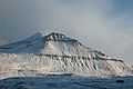
Slættaratindur during winter.

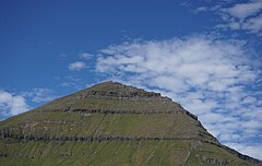
Slættaratindur seen from the streets of Funningur.


References[]
 Definitions from Wiktionary
 Media from Wikimedia Commons
 News from Wikinews
 Quotations from Wikiquote
 Texts from Wikisource
 Textbooks from Wikibooks
 Resources from Wikiversity

This Faroe Islands location article is a stub. You can help Wikipedia by . |
- Mountains of the Faroe Islands
- Faroe Islands geography stubs