Orava (region)


Orava is the traditional name of a region situated in northern Slovakia (as Orava) and partially also in southern Poland (as Orawa). It encompasses the territory of the former comitatus (county) of Árva (or Arwa in German).
Etymology[]
The name arises from the Orava river (a major river flowing through the region).
History[]
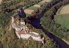
The county arose before the 15th century. The county's territory was situated along the Orava River between Zázrivá and the Tatra Mountains. Its area amounted to 2,019 km2 (780 sq mi) around 1910. The original seat of the county was Orava Castle.
Geography[]
Orava is now recognized as one of Slovakia's 25 tourist regions, however, it is not an administrative region unlike its predecessor. In Slovakia, Orava is divided between Dolný Kubín, Tvrdošín, and Námestovo districts in the Žilina Region. It has an area of 1,661 km2 (641 sq mi),[1] with the population on the Slovak side around 126,000.[2] The village of Oravská Polhora is the northernmost settlement of Slovakia. The most important town on the Slovak side (and also the seat of the former county) is Dolný Kubín. The Polish part of Orava belongs to the Lesser Poland Voivodeship, to the Nowy Targ County, with the main village of the Polish side being Jabłonka.
References[]
- ^ "Orava - index page". Archived from the original on 2007-07-09. Retrieved 2020-04-26.
- ^ Mestská a obecná štatistika SR
External links[]
Coordinates: 49°15′42″N 19°21′29″E / 49.261569°N 19.358056°E

| hide Authority control | |
|---|---|
| General |
|
| National libraries | |
This Poland location article is a stub. You can help Wikipedia by . |
- Traditional regions of Slovakia
- Regions of Poland
- Slovakia geography stubs
- Poland geography stubs