Babie
Babie | |
|---|---|
Municipality | |
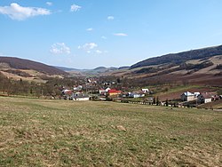 | |
 Babie Location of Babie in the Prešov Region | |
| Coordinates: 49°04′0″N 21°30′0″E / 49.06667°N 21.50000°ECoordinates: 49°04′0″N 21°30′0″E / 49.06667°N 21.50000°E | |
| Country | |
| Region | Prešov |
| District | Vranov nad Topľou |
| First mentioned | 1330 |
| Government | |
| • Mayor | Martina Hliboká |
| Area | |
| • Total | 8 km2 (3 sq mi) |
| Elevation | 204 m (669 ft) |
| Population | |
| • Total | 252 |
| • Density | 32/km2 (82/sq mi) |
| Time zone | UTC+1 (CET) |
| • Summer (DST) | UTC+2 (CEST) |
| Postal code | 094 31 (pošta Hanušovce nad Topľou) |
| Area code(s) | 057 |
| Car plate | VT |
| Website | babie |


Babie (Hungarian: Bábafalva) is a village and municipality in the Vranov nad Topľou District in the Prešov Region of Slovakia.
Population[]
According to the 2011 census, the municipality had 252 inhabitants. All inhabitants were Slovaks.[1]
Genealogical resources[]
The records for genealogical research are available at the state archive "Statny Archiv in Presov, Slovakia"
- Roman Catholic church records (births/marriages/deaths): 1766-1897
- Greek Catholic church records (births/marriages/deaths): 1847-1939
- Lutheran church records (births/marriages/deaths): 1766-1895
- Census records 1869 of Babie are available at the state archive.
See also[]
References[]
- ^ "OBCE Narodnost" (PDF). Archived from the original (PDF) on 2012-11-14. Retrieved 2012-11-14.
External links[]
 Media related to Babie (Vranov nad Topľou District) at Wikimedia Commons
- Official website

- http://en.db-city.com/Slovakia/Pre%C5%A1ov/Vranov_nad_Top%C4%BEou/Babie
- Surnames of living people in Babie
This Prešov Region geography article is a stub. You can help Wikipedia by . |
Categories:
- Villages and municipalities in Vranov nad Topľou District
- Šariš
- Prešov Region geography stubs