Regions of Slovakia
| Regions of Slovakia Kraje Slovenska | |
|---|---|
| Category | Unitary state |
| Location | Slovak Republic |
| Number | 8 Regions |
| Populations | 563,591 (Trnava) – 825,022 (Prešov) |
| Areas | 2,052.6 km2 (792.5 sq mi) (Bratislava) – 9,454.8 km2 (3,650.5 sq mi) (Banská Bystrica) |
| Government |
|
| Subdivisions | |
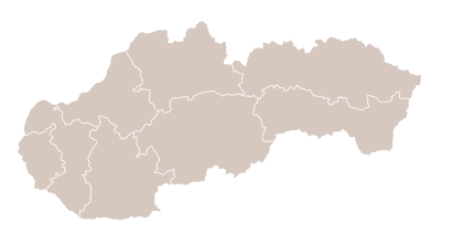
Since 1949 (except 1990–1996), Slovakia has been divided into a number of kraje (singular kraj; usually translated as "Regions" with capital R).[1] Their number, borders and functions have been changed several times. There are eight regions of Slovakia and they correspond to the EU's NUTS 3 level of local administrative units. Each kraj consists of okresy (counties or districts). There are 79 districts.
List[]
After a period without kraje and without any equivalent (1990–1996), the kraje were reintroduced in 1996. As for administrative division, Slovakia has been subdivided into 8 kraje since 24 July 1996:
| Flag | Arms | Region | Capital | Population (2018) | Area (km2) | Density | NUTS level 3 | Seats
in Regional Council |
|---|---|---|---|---|---|---|---|---|
| Bratislava | Bratislava | 2,052.6 | 321.34 | SK010 | 50 | |||
| Trnava | Trnava | 4,172.2 | 135.08 | SK021 | 40 | |||
| Trenčín | Trenčín | 4,501.9 | 130.14 | SK022 | 47 | |||
| Nitra | Nitra | 6,343.4 | 106.67 | SK023 | 54 | |||
| Žilina | Žilina | 6,808.4 | 101.54 | SK031 | 57 | |||
| Banská Bystrica | Banská Bystrica | 9,454.8 | 68.52 | SK032 | 49 | |||
| Prešov | Prešov | 8,974.5 | 91.92 | SK041 | 62 | |||
| Košice | Košice | 6,751.9 | 118.32 | SK042 | 57 | |||
| Total | 5 427 917 | 49 035 | 111.3 | 416 | ||||
Since 2002, Slovakia is divided into 8 samosprávne kraje (self-governing regions), which are called by the Constitution vyššie územné celky (Higher Territorial Units), abbr. VÚC. The territory and borders of the self-governing regions are identical with the territory and borders of the kraje. Therefore, the word "kraj" can be replaced by "VÚC" or "samosprávny kraj" in each case in the above list. The main difference is that organs of samosprávne kraje are self-governing, with an elected chairperson and assembly, while the organs of kraje are appointed by the government.
Name[]
The term "Region" (Slovak: kraj) should not be confused with:
- the general (i.e. non-administrative) term "region" (Slovak: región) as it is used for example in the articles List of traditional regions of Slovakia or List of tourism regions of Slovakia
- the 4 "regions" (Slovak: regióny or oblasti or zoskupenia krajov) that correspond to the NUTS 2 level, i.e. groups of several kraje, used by the Eurostat for statistical purposes. These are:
- Bratislava SK 01 (Bratislava Region) – comprises only this single kraj
- Západné Slovensko SK 02 (Western Slovakia) – Trnava, Trenčín and Nitra
- Stredné Slovensko SK 03 (Central Slovakia) – Žilina and Banská Bystrica
- Východné Slovensko SK 04 (Eastern Slovakia) – Prešov and Košice
History[]
Prior to 1949[]
Historically, Slovakia was not divided into kraje, but into counties (Slovak: župy or stolice). This was the case when present-day Slovakia was part of:
- Great Moravia (cca. 9th century)
- the Kingdom of Hungary (cca. 11th / 12th century – 1918)
- Czechoslovakia (the župy existed 1918 – 1928)
- the WWII Slovak Republic (the župy existed 1940 – 1945)
In 1928–1939 (and formally also 1945–1948) Slovakia as a whole formed the administrative unit "Slovak land" (Krajina slovenská) within Czechoslovakia.
24 December 1948/1 January 1949 – 30 June 1960[]
- Bratislavský kraj (Bratislava Region)
- Banskobystrický kraj (Banská Bystrica Region)
- Košický kraj (Košice Region)
- Nitriansky kraj (Nitra Region)
- Prešovský kraj (Prešov Region)
- Žilinský kraj (Žilina Region)
Each kraj was named after its principal city.
July 1, 1960 – December 19, 1990[]
- Stredoslovenský kraj (Central Slovak Region)
- Východoslovenský kraj (Eastern Slovak Region)
- Západoslovenský kraj (Western Slovak Region)
- Bratislava (before March 22, 1968, part of the Západoslovenský kraj, afterwards a partly separate entity; from January 1971 a separate kraj)
Note: The kraje were abolished from July 1, 1969, to December 28, 1970, and reintroduced then.
See also[]
- List of traditional regions of Slovakia
- List of tourism regions of Slovakia
- Districts of Slovakia
- Counties of Slovakia
- Flags of Slovak Regions
- ISO 3166-2:SK
References[]
External links[]
- EU-maps (the kraje correspond to the NUTS 3 level with EUROSTAT)
- Former names of all Slovakia´s towns and villages prior IWW (prior 1918)
- Nature and lanscsape of Eastern Slovakia in photo

- Regions of Slovakia
- Subdivisions of Slovakia
- Lists of administrative divisions
- Administrative divisions in Europe
- First-level administrative divisions by country
- Slovakia geography-related lists