Nitra Region
Nitra Region
Nitriansky kraj | |
|---|---|
 | |
 Flag  Coat of arms | |
 Nitra Region | |
| Country | |
| Capital | Nitra |
| Government | |
| • Governor | Milan Belica |
| Area | |
| • Total | 6,343.94 km2 (2,449.41 sq mi) |
| Highest elevation | 943 m (3,094 ft) |
| Population (2011 census) | |
| • Total | 689,867 |
| • Density | 110/km2 (280/sq mi) |
| Time zone | UTC+1 (CET) |
| • Summer (DST) | UTC+2 (CEST) |
| ISO 3166 code | SK-NI |
| Website | www |
The Nitra Region (Slovak: Nitriansky kraj, pronounced [ˈɲitrɪɐnski ˈkraj]; Hungarian: Nyitrai kerület) is one of the administrative regions of Slovakia. It was first established in 1923 and from 1996 exists in its present borders. It consists of seven districts (Slovak: okres) and 354 municipalities, from which 16 have a town status. The economy of the region focuses more on agriculture, than in other Slovak regions. Nitra is its seat, largest city, and cultural and economic center.
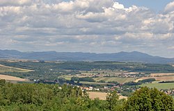
Geography[]
This region with a long history is situated in the southwest of Slovakia, mostly in the eastern part of the Danubian Lowland. It is divided into two sub-units: the Danubian Flat in the south-west, with eastern part of the Žitný ostrov island, and the Danubian Hills in the north, centre and east. Mountain ranges reaching into the region are: Považský Inovec in the north-west, where the region's highest point, , is located, Tribeč in the north from Nitra, Pohronský Inovec in the north-east and Štiavnické vrchy in the east. Major rivers are the Danube in the south, Váh in the south-west, Nitra in the western-central part, Hron in the east and Ipeľ in the south-east. As for administrative divisions, the region borders Trenčín Region in the north, Banská Bystrica Region in the east, Hungarian Pest in the south-east, Komárom-Esztergom in the south, and Győr-Moson-Sopron county in the south-west and Trnava Region in the west.
Demographics[]
The population density in the region is 106/km2 (270/sq mi) (2020-06-30/-07-01),[1], which is very similar to the country's average (110 per km2). The largest towns are Nitra, Komárno, Nové Zámky and Levice. According to the 2001 census, there were 713,422 inhabitants in the region, with a majority of Slovaks (68.3%), but there is a numerous Hungarian minority (27.6%) in the southern districts, forming a majority in the Komárno District (72%) and there are small minorities of Czechs and Roma (<1%).[2]
| Year | 1994 | 1999 | 2014 | 2019 | 2020 |
|---|---|---|---|---|---|
| Population | 718,358 | 715,841 | 709,350 | 705,661 | 684,922 |
Data are year-end. The time zone is CET.
Economy and climate[]
The city of Nitra is also the centre of whole region. The region - which is the warmest in Slovakia - reaches a high production of wheat, rye and vegetables. Significant industries are: the food industry, with breweries in Topoľčany, Nitra and Hurbanovo, are machinery (fridges in Zlaté Moravce, shipyards in Komárno) and energy (Mochovce Nuclear Power Plant).
Administrative division[]
The Nitra Region consists of 7 districts. There are 350 municipalities, of which 16 are towns.
See also[]
- Nyitra County of the Kingdom of Hungary
References[]
- ^ "Statistic of Slovak places by Dušan Kreheľ – Export". Retrieved 2021-07-05.
- ^ POPULATION AND HOUSING CENSUS 2001 - Tab. 3a
- ^ "Statistic of Slovak places by Dušan Kreheľ – Export". Retrieved 2021-06-27.
- Kopa, Ľudovít; et al. (2006). The Encyclopaedia of Slovakia and the Slovaks. Bratislava, Slovakia: Encyclopaedic Institute of the Slovak Academy of Sciences. ISBN 80-224-0925-1. External link in
|publisher=(help)
External links[]
- Nitriansky samosprávny kraj Official website
| show |
|---|
| show Authority control |
|---|
- Nitra Region
- Regions of Slovakia
- 1923 establishments in Slovakia