Bajtava
Bajtava | |
|---|---|
Municipality and village | |
 | |
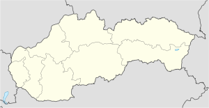 Bajtava Location in Slovakia | |
| Coordinates: 47°51′N 18°45′E / 47.850°N 18.750°E | |
| Country | |
| Region | Nitra Region |
| District | Nové Zámky District |
| Area | |
| • Total | 3.60 sq mi (9.33 km2) |
| Population (2004) | |
| • Total | 388 |
| Time zone | UTC+1 (CET) |
| • Summer (DST) | UTC+2 (CEST) |

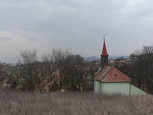
Bajtava (Hungarian: Bajta) is a municipality and village in the Nové Zámky District in the Nitra Region of south-west Slovakia.
History[]
In historical records the village was first mentioned in 1261.
Geography[]
The village lies at an altitude of 197 metres and covers an area of 9.33 km2 (3.60 sq mi). It has a population of 388 (2004).
Ethnicity[]
The population is about 91% Hungarian and 6% Slovak.
Genealogical resources[]
The records for genealogical research are available at the state archive "Statny Archiv in Nitra, Slovakia"
- Roman Catholic church records (births/marriages/deaths): 1718-1787 (parish B), 1837-1895 (parish A)
- Census records 1869 of Bajtava are not available at the state archive.
See also[]
External links[]
| Wikimedia Commons has media related to Bajtava. |
- https://web.archive.org/web/20100202015957/http://www.statistics.sk/mosmis/eng/run.html
- Surnames of living people in Bajtava
- Bajtava – Nové Zámky okolie
Coordinates: 47°51′N 18°45′E / 47.850°N 18.750°E
This Nitra Region geography article is a stub. You can help Wikipedia by . |
Categories:
- Villages and municipalities in Nové Zámky District
- Nitra Region geography stubs