Cața
Cața
Kaca | |
|---|---|
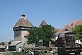
 View of Drăușeni | |
 Location within the county | |
 Cața Location in Romania | |
| Coordinates: 46°5′N 25°16′E / 46.083°N 25.267°ECoordinates: 46°5′N 25°16′E / 46.083°N 25.267°E | |
| Country | Romania |
| County | Brașov |
| Government | |
| • Mayor (2020–2024) | Liviu Ioan Vocilă[1] (PNL) |
| Area | 118.12 km2 (45.61 sq mi) |
| Population (2011)[2] | 2,463 |
| • Density | 21/km2 (54/sq mi) |
| Time zone | EET/EEST (UTC+2/+3) |
| Vehicle reg. | BV |
| Website | www |

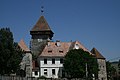
Cața (German: Katzendorf; Hungarian: Kaca) is a commune in Brașov County, Transylvania, Romania. It is composed of five villages: Beia, Cața, Drăușeni, Ionești, and Paloș. There are three fortified churches in the commune, at Cața, Beia, and Drăușeni.
The commune is located in the northernmost part of the county, on the border with Harghita and Mureș counties. Cața village—the administrative center of the commune—is 69 km (43 mi) northwest of Brașov (the county seat) and 36 km (22 mi) south of Odorheiu Secuiesc. At the 2011 census, 44.9% of inhabitants were Romanians, 30.9% Hungarians, and 23.4% Roma.
| In Romanian | In German | In Hungarian |
|---|---|---|
| Beia | Meeburg | Homoródbene |
| Cața | Katzendorf | Kaca |
| Drăușeni | Draas | Homoróddaróc |
| Ionești | Eisdorf | Homoródjánosfalva |
| Paloș | Königsdorf | Pálos |
Fortified church of Cața
Fortified church of Drăușeni


References[]
- ^ "Results of the 2020 local elections". Central Electoral Bureau. Retrieved 9 June 2021.
- ^ "Populaţia stabilă pe judeţe, municipii, oraşe şi localităti componenete la RPL_2011" (in Romanian). National Institute of Statistics. Retrieved 4 February 2014.

| Authority control |
|---|
This Brașov County location article is a stub. You can help Wikipedia by . |
Categories:
- Communes in Brașov County
- Localities in Transylvania
- Brașov County geography stubs