Babinda Boulders
| Boulders Scenic Reserve Queensland | |
|---|---|
 The main swimming hole at Babinda Boulders | |
 Boulders Scenic Reserve | |
| Nearest town or city | Babinda |
| Coordinates | 17°20′30″S 145°52′10″E / 17.34167°S 145.86944°E |
| Managing authorities | Cairns Regional Council |
| Website | Boulders Scenic Reserve |

Babinda Boulders, officially called the Boulders Scenic Reserve[1] but known locally as Babinda Boulders or simply the Boulders, is a public recreation reserve managed by the Cairns Regional Council and adjacent to the Wooroonooran National Park in far north Queensland, Australia.
Description[]
The Boulders Scenic Reserve encompasses a section of Babinda Creek where several smaller tributaries join it. Most of the site, apart from the picnic and play areas adjacent to the main swimming hole, is covered by dense tropical rainforest. It lies in the foothills between Queensland's highest and second-highest mountain peaks – Mount Bartle Frere and Mount Bellenden Ker respectively.[2][3][4] This high coastal mountain range, the tropical location and the moist south-easterly trade winds are responsible for making the coastal strip between Tully and Cape Tribulation the wettest area in all of Australia,[5][6][7] and as a result a constant supply of cool mountain water flows through all the creeks of the reserve.
Location[]
Access to the Boulders Scenic Reserve is via the town of Babinda which is about 60 km (37 mi) south of Cairns and about 30 km (19 mi) north of Innisfail on the Bruce Highway. The reserve is located about 6 km (3.7 mi) to the west of the town.[1][2]
Facilities[]
The site is well suited for families, boasting spacious and calm swimming holes with clear cool water year round, a picnic area with tables and free gas barbeques, toilets and showers, swings, grassed areas, viewing platforms, and walking tracks. There is also a free camping ground close by.[1][2]
Walks[]

There are three walking tracks within the Boulders Reserve:
- Wonga Circuit Track: an easy 850 m (0.53 mi) loop walk which takes one through rainforest alongside both North Babinda Creek and Babinda Creek.
- Devil's Pool Walk: this 1.2 km (0.75 mi) return walk takes the visitor alongside a lower section of Babinda Creek. There are two viewing platforms where the spectacular and dangerous rock formations may be observed.
- Goldfield Trail: a track for more serious walkers, it begins from the reserve and leads north west approximately 19 km (12 mi) over a saddle in the Bellenden Ker Range to the Goldsborough Valley.[8]
Indigenous names[]
In the language of the local indigenous Yidinji people the area is called Bunna Binda meaning "waterfall" or "water over your shoulder". The town name "Babinda" is derived from the indigenous one. Wonga is a local indigenous family name. The original Yidinji name for Mt Bartle Frere is Chooreechillum.[4][9][10][11]
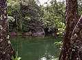
Devil's Pool[]
The Devil's Pool is at the top of a perilous section of Babinda Creek. Approximately 700 m (770 yd) downstream from the main swimming hole the river valley narrows considerably and the creek channel is filled with massive boulders and lined with bedrock, all of which have been polished smooth by the water flow over countless millennia. In the dry season the water in Babinda Creek passes over and under these rocks, sometimes disappearing from view altogether, while in the wet season the boulders are often completely covered. Regardless of the season, the rocks are treacherously slippery when wet and sadly many casual visitors have slipped into the stream and been dragged by the strong current to their deaths, while others have drowned while attempting to swim in the Devil's Pool.[12][13]
Gallery[]
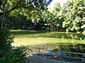
The main swimming hole at the Boulders Scenic Reserve, Babinda, Queensland
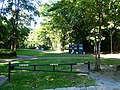
Babinda boulders picnic area

A picnic shelter at Babinda Boulders

One of the public barbeques at Babinda Boulders Scenic Reserve

Swimming in Babinda Creek, upstream from the main recreation area

The Boulders main swimming hole
The main swimming hole

Water rushing between boulders from the Devil's Pool

Babinda Creek below the Devil's Pool


References[]
- ^ a b c "The Boulders, Babinda". Cairns Regional Council. Retrieved 12 December 2020.
- ^ a b c "Babinda Information Centre". Retrieved 16 December 2020.
- ^ "Babinda, QLD – Aussie Towns". Retrieved 16 December 2020.
- ^ a b "Job Search – Employment and jobs". Queensland Government. Archived from the original on 16 December 2020. Retrieved 16 December 2020.
- ^ "Climatic Extremes – Geoscience Australia". Australian Government. Retrieved 16 December 2020.
- ^ "'It can be freaky': Meet the man who checks Australia's wettest rain gauge". Australian Broadcasting Corporation. Retrieved 16 December 2020.
- ^ "Welcome to the wettest place in Australia – 9News". Retrieved 16 December 2020.
- ^ "Goldfield Trail, Wooroonooran National Park". Department of Environment and Science, Queensland Government. Retrieved 16 December 2020.
- ^ "indigenous Culture and History". Cairns Regional Council. Retrieved 16 December 2020.
- ^ "Nature, culture and history – Goldfield Trail – Wooroonooran National Park". Department of Environment and Science, Queensland Government. Retrieved 16 December 2020.
- ^ "Wonga Park". Cairns Regional Council. Retrieved 16 December 2020.
- ^ "Search underway for missing Brisbane man who disappeared while swimming at notorious Babinda Boulders waterhole in Far North Queensland". Australian Broadcasting Corporation. Retrieved 10 December 2020.
- ^ "Search expanded for teen missing at notorious far north Qld swimming spot". Brisbane Times. Retrieved 9 January 2021.
- Babinda
- Rainforests
- Protected areas of Queensland