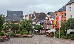
Bad Neuenahr-Ahrweiler
Bad Neuenahr-Ahrweiler | |
|---|---|
 | |
 Coat of arms | |
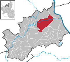
show Location of Bad Neuenahr-Ahrweiler within Ahrweiler district | |
 Bad Neuenahr-Ahrweiler | |
| Coordinates: 50°32′41″N 7°6′48″E / 50.54472°N 7.11333°ECoordinates: 50°32′41″N 7°6′48″E / 50.54472°N 7.11333°E | |
| Country | Germany |
| State | Rhineland-Palatinate |
| District | Ahrweiler |
| Subdivisions | Ortsbezirke 13 |
| Government | |
| • Mayor (2017–25) | Guido Orthen[1] (CDU) |
| Area | |
| • Total | 63.4 km2 (24.5 sq mi) |
| Elevation | 99 m (325 ft) |
| Population (2020-12-31)[2] | |
| • Total | 28,634 |
| • Density | 450/km2 (1,200/sq mi) |
| Time zone | UTC+01:00 (CET) |
| • Summer (DST) | UTC+02:00 (CEST) |
| Postal codes | 53474 |
| Dialling codes | 02641; 02646 |
| Vehicle registration | AW |
| Website | www.bad-neuenahr-ahrweiler.de |


Bad Neuenahr-Ahrweiler (German pronunciation: [baːt ˌnɔʏənʔaːɐ̯ˈʔaːɐ̯vaɪlɐ]) is a spa town in the German Bundesland of Rhineland-Palatinate that serves as the capital of the Ahrweiler district. The A61 motorway connects the town with cities like Cologne and Mainz. Formed by the merging of the towns (now districts) of Bad Neuenahr and Ahrweiler in 1969, Bad Neuenahr-Ahrweiler consists of 11 such districts.
Geography[]
Bad Neuenahr-Ahrweiler rests in the Ahr valley (German: Ahrtal) on the left bank of the Rhine river in the north of Rhineland-Palatinate. Bad Neuenahr-Ahrweiler nestles in the Ahr Hills (German: Ahrgebirge).
The highest hill in the area is the Häuschen at 506 metres (1,660 ft) metres above sea level. Nearby are the hills of Steckenberg, Neuenahrer, and Talerweiterung. There used to be castles on the last two of these hills.
Neighbouring communities[]
Bad Neuenahr-Ahrweiler is surrounded by the following villages and towns (clockwise from the north): Grafschaft, Remagen, Sinzig, Königsfeld, Schalkenbach, Heckenbach, Kesseling, Rech and Dernau. The nearest cities are Bonn and Koblenz.
Districts[]
Bad Neuenahr is divided into Ortsbezirke which consist of one or more districts. The Ortsbezirke be represented by local councils. The largest district, Bad Neuenahr, was originally made up of three communities, which are still seen as districts.
Population statistics as of 31 March 2013 (main and secondary residence):[3]
| Local District | Subdivision | Population (30 June 2015) |
|---|---|---|
| Ahrweiler | District: Ahrweiler | 7,411 |
| Bachem | District: Bachem | 1,214 |
| Bad Neuenahr | Districts: Beul, and | 12,132 |
| Gimmigen | District: Gimmigen | 735 |
| Heimersheim | District: Heimersheim and | 3,194 |
| Heppingen | District: Heppingen | 873 |
| Kirchdaun | District: Kirchdaun | 368 |
| Lohrsdorf | District: Lohrsdorf and | 672 |
| Ramersbach | District: Ramersbach | 567 |
| Walporzheim | District: Walporzheim and Marienthal | 698 |
Climate[]
| hideClimate data for Bad Neuenahr-Ahrweiler (1991-2020) | |||||||||||||
|---|---|---|---|---|---|---|---|---|---|---|---|---|---|
| Month | Jan | Feb | Mar | Apr | May | Jun | Jul | Aug | Sep | Oct | Nov | Dec | Year |
| Record high °C (°F) | 16.9 (62.4) |
20.7 (69.3) |
25.4 (77.7) |
30.5 (86.9) |
33.4 (92.1) |
36.4 (97.5) |
40.4 (104.7) |
38.9 (102.0) |
34.5 (94.1) |
28.5 (83.3) |
22.4 (72.3) |
19.0 (66.2) |
40.4 (104.7) |
| Average high °C (°F) | 5.9 (42.6) |
7.3 (45.1) |
11.4 (52.5) |
15.9 (60.6) |
19.8 (67.6) |
22.9 (73.2) |
25.2 (77.4) |
25.1 (77.2) |
20.7 (69.3) |
15.5 (59.9) |
10.0 (50.0) |
6.5 (43.7) |
15.5 (59.9) |
| Daily mean °C (°F) | 2.9 (37.2) |
3.5 (38.3) |
6.5 (43.7) |
10.2 (50.4) |
14.1 (57.4) |
17.2 (63.0) |
19.2 (66.6) |
18.7 (65.7) |
14.7 (58.5) |
10.5 (50.9) |
6.5 (43.7) |
3.6 (38.5) |
10.6 (51.1) |
| Average low °C (°F) | −0.3 (31.5) |
−0.2 (31.6) |
2.1 (35.8) |
4.6 (40.3) |
8.4 (47.1) |
11.6 (52.9) |
13.5 (56.3) |
13.1 (55.6) |
9.6 (49.3) |
6.0 (42.8) |
2.9 (37.2) |
0.5 (32.9) |
6.0 (42.8) |
| Record low °C (°F) | −20.3 (−4.5) |
−21.8 (−7.2) |
−14.1 (6.6) |
−6.4 (20.5) |
−2.7 (27.1) |
1.6 (34.9) |
4.0 (39.2) |
4.5 (40.1) |
0.1 (32.2) |
−7.0 (19.4) |
−12.5 (9.5) |
−20.1 (−4.2) |
−21.8 (−7.2) |
| Average precipitation mm (inches) | 46.0 (1.81) |
42.0 (1.65) |
48.0 (1.89) |
39.0 (1.54) |
58.0 (2.28) |
60.0 (2.36) |
62.0 (2.44) |
64.0 (2.52) |
53.0 (2.09) |
49.0 (1.93) |
46.0 (1.81) |
53.0 (2.09) |
620.0 (24.41) |
| Source: wetterlabs.de: Bad Neuenahr-Ahrweiler | |||||||||||||
History[]


Antiquity[]
Discoveries dating to Hallstatt period (1000–500 BC) shows farming activity by local Celts that dwelled in the area. The Gallic Wars (58–50 BC) resulted in the forced relocation of the indigenous Eburones people to the Middle Rhine. From the 1st to 3rd century, several Roman discoveries were made. Most notable is the .
Middle Ages[]
In 893 AD, Ahrweiler was mentioned as Arwilre, Arewilre, Arewilere, and later Areweiller in the Prüm Urbar (register of estates owned by Prüm Abbey). The abbey of Ahrweiler owned a manor with 24 farmsteads; 50 acres of farmland and 76 acres of vineyards. The first mention of a parish church occurred in Neuenahr Castle and surrounding county (Newenare) from 1204 to 1225. In 1246 was founded one of the oldest German inns Gasthaus Sanct Peter.
Modern Times[]
During the 2021 European floods much of the town was submerged and many died.[4]
Economy[]
- The German Army's (German: Deutsches Heer) Logistics Centre (main depot) is located in an underground facility.
- Bad Neuenahr-Ahrweiler has been home to the traditional mineral water "Heppinger" since 1584.
- The "Apollinaris" mineral water company was founded in Bad Neuenahr in 1852.
Transport[]
The town has five stations on the Ahr Valley Railway and provides hourly connections to Bonn.
Sport[]
- Bad Neuenahr-Ahrweiler is the home of the successful women's football team, SC 07 Bad Neuenahr.
Twin towns – sister cities[]
Bad Neuenahr-Ahrweiler is twinned with:[5]
 Brasschaat, Belgium
Notable people[]

- Cyrillus Jarre (1878–1952), Franciscan Archbishop in Jinan
- Markus Stenz (born 1965), conductor
- Björn Glasner (born 1973), cyclist
- Jan van Eijden (born 1976), cyclist
- Pierre Kaffer (born 1976), racing driver
- Bianca Rech (born 1981), footballer
- Ricarda Funk (born 1992), canoeist
Associated with the town[]
- Karl Marx (1818–1883), philosopher and economist, stayed in a spa resort in Bad Neuenahr in 1877
- Peter Friedhofen (1819–1860), founder of the Charitable Brethren of Maria Hilf, who practiced his trade first in Ahrweiler
- Wolfgang Müller von Königswinter (1816–1873), novelist and poet, died in Bad Neuenahr
- Maria Magdalena Merten (1883–1918), nun, member of the Ursulines near Ahrweiler
- Ebba Tesdorpf (1851–1920), illustrator and watercolorist, died in Ahrweiler
- Paul Metternich (1853–1934), diplomat, died in the district of Heppingen
- Max von Schillings (1868–1933), composer and conductor
- Christian Hülsmeyer (1891–1957), inventor, physicist and entrepreneur, died in Ahrweiler
References[]
- ^ Wahlen der Bürgermeister der verbandsfreien Gemeinden, Landeswahlleiter Rheinland-Pfalz, accessed 30 July 2021.
- ^ "Bevölkerungsstand 2020, Kreise, Gemeinden, Verbandsgemeinden". Statistisches Landesamt Rheinland-Pfalz (in German). 2021.
- ^ "Zahlen & Daten Bad Neuenahr-Ahrweiler". Stadt Bad Neuenahr-Ahrweiler – offizielle Website.
- ^ "More than 100 dead as flood 'catastrophe' hits Germany and Belgium". the Guardian. July 16, 2021.
- ^ "Städtepartnerschaft mit Brasschaat". bad-neuenahr-ahrweiler.de (in German). Bad Neuenahr-Ahrweiler. Retrieved 2021-03-10.
External links[]
| Wikimedia Commons has media related to Bad Neuenahr-Ahrweiler. |
| Wikivoyage has a travel guide for Bad Neuenahr-Ahrweiler. |
- . Encyclopædia Britannica. 19 (11th ed.). 1911. p. 425.
- Official website
 (in German)
| show Authority control |
|---|
- Towns in Rhineland-Palatinate
- Spa towns in Germany
- Populated places in Ahrweiler (district)