Badia Tedalda
Badia Tedalda | |
|---|---|
| Comune di Badia Tedalda | |
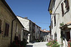 Via Castello in Badia Tedalda Alta | |
show Location of Badia Tedalda | |
 Badia Tedalda Location of Badia Tedalda in Italy | |
| Coordinates: 43°42′N 12°11′E / 43.700°N 12.183°ECoordinates: 43°42′N 12°11′E / 43.700°N 12.183°E | |
| Country | Italy |
| Region | Tuscany |
| Province | Arezzo (AR) |
| Frazioni | Arsicci, Caprile, , Fresciano, Montelabreve, Monte Viale, Pratieghi, Rofelle, Sant’Andrea, Santa Sofia Capannello, , , Stiavola, Svolta del Podere |
| Government | |
| • Mayor | Alberto Santucci (since June 2004) |
| Area | |
| • Total | 119.1 km2 (46.0 sq mi) |
| Elevation | 700 m (2,300 ft) |
| Population (31 August 2007)[3] | |
| • Total | 1,183 |
| • Density | 9.9/km2 (26/sq mi) |
| Demonym(s) | Badiali |
| Time zone | UTC+1 (CET) |
| • Summer (DST) | UTC+2 (CEST) |
| Postal code | 53032 |
| Dialing code | 0575 |
| Patron saint | St. Michael Archangel |
| Saint day | September 29 |


Badia Tedalda is a comune (municipality) in the Province of Arezzo in the Italian region Tuscany, located about 80 kilometres (50 mi) east of Florence and about 35 kilometres (22 mi) northeast of Arezzo. Two of its frazioni, Santa Sofia Marecchia and Cicognaia, form an exclave (Ca' Raffaello) in the province of Arezzo.
References[]
| Wikimedia Commons has media related to Badia Tedalda. |
- ^ "Superficie di Comuni Province e Regioni italiane al 9 ottobre 2011". Istat. Retrieved 16 March 2019.
- ^ "Popolazione Residente al 1° Gennaio 2018". Istat. Retrieved 16 March 2019.
- ^ All demographics and other statistics: Italian statistical institute Istat.
Categories:
- Cities and towns in Tuscany
- Municipalities of the Province of Arezzo
- Tuscany geography stubs