Badimalika
Badimalika Municipality
बडिमालिका नगरपालिका | |
|---|---|
 Badimalika Peak as seen from Bamta, Bajura, Nepal | |
 Badimalika Municipality Location in Nepal | |
| Coordinates: 29°26′N 81°08′E / 29.44°N 81.14°ECoordinates: 29°26′N 81°08′E / 29.44°N 81.14°E | |
| Country | |
| Province | Sudurpashchim Province |
| District | Bajura |
| Municipality | Badimalika |
| No.of wards | 9 |
| Government | |
| • Mayor | Padam Baduwal |
| • Deputy Mayor | Kabita Kumari Budha(Bista) |
| Area | |
| • Total | 276 km2 (107 sq mi) |
| Population (2017/18) | |
| • Total | 16,818 |
| • Density | 61/km2 (160/sq mi) |
| • Religion | Hindu |
| Time zone | UTC+5:45 (Nepal Time) |
| Postal code | 10600 |
| Website | http://badimalikamun.gov.np/ |

Badimalika Municipality (Nepali: बडिमालिका नगरपालिका) is a newly formed municipality in Bajura District in the Sudurpashchim Province of Nepal.[1] It was formed in March, 2017 as decided by the Cabinet in line with the Constitution of Nepal 2015[2]
History[]
The name of this municipality is derived from the name of the famous religious place Badimalika Mai located in Triveni Municipality of this district. It is formed by merging previous 3 VDC named Martadi, Budiganga and Jugada.[3]
Area and Population[]
The population of this municipality is about 16,818 with 3,446 household. The average size of household is 4.88. It is the least populated municipality among other municipalities of Bajura district, while it is the largest municipality on the basis of area. The total area of this municipality is (107 sq mi.). Mardati Bazzar is the local trade center of this municipality. District hospital and many other government offices are also located here.
Geography[]
This municipality is located in the middle of Bajura district. It has Budhinanda Municipality in the East, Gaumul Rural Municipality, Chhededaha Rural Municipality and Budhiganga Municipality in the West, Budhinanda Municipality in the North while Triveni Municipality in the South.
References[]
Headquarters: Martadi (today part of Badimalika) | ||
| Municipality | 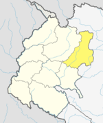 | |
| Rural municipalities | ||
| Former VDCs | ||
List of municipalities and rural municipalities of Nepal | ||
- Nepal municipalities established in 2017
- Bajura District
- Municipalities in Bajura District