Himali Rural Municipality
Himali Rural Municipality
हमाली गाउपालिका | |
|---|---|
 Himali Rural Municipality Location in Nepal | |
| Coordinates: 29°32′N 81°40′E / 29.53°N 81.67°ECoordinates: 29°32′N 81°40′E / 29.53°N 81.67°E | |
| Country | |
| Province | Sudurpashchim Province |
| District | Bajura |
| Municipality | Himali Rural Municipality |
| No.of wards | 7 |
| Government | |
| • Type | Rural Council |
| • Mayor | Govinda Bahadur Malla |
| • Deputy Mayor | Chandra Devi Buddha |
| Area | |
| • Total | 830.33 km2 (320.59 sq mi) |
| Population (2017/18) | |
| • Total | 9,214 |
| • Religion | Hindu Buddhist |
| Time zone | UTC+5:45 (Nepal Time) |
| Postal code | 10600 |
| Headquarter | |
| Website | http://himalimun.gov.np/ |

Himali (Nepali: हमाली गाउँपालिका) is the newly formed rural municipality in Bajura District in the Sudurpashchim Province of Nepal. It was formed in March 2017, when Government of Nepal announced 744 local level units in line with the Constitution of Nepal 2015.[1] It lies in the northern region of Bajura District and is also considered to be the remote place of this district.
History[]
It is formed by merging previous VDCs named Bichhiya, Rugin and ward no. 1 to 7 of Baddhu VDC.[2] There is snowfall throughout the year in this region.
Himali Rural Municipality has an area of 830.33 square kilometres (320.59 sq mi) and the population of this municipality is 9,214. It is the second smallest rural municipality of Bajura district in terms of population. It is divided into 7 wards and the headquarter of this newly formed municipality is situated at .
References[]
- ^ "New local level structure comes into effect from today". The Himalayan Times. March 10, 2017.
- ^ "Final District 1-75 Corrected Last for RAJAPATRA" (PDF). mofald.gov.np (in Nepali).
Headquarters: Martadi (today part of Badimalika) | ||
| Municipality | 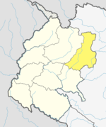 | |
| Rural municipalities | ||
| Former VDCs | ||
List of municipalities and rural municipalities of Nepal | ||
- Rural municipalities in Bajura District
- Rural municipalities of Nepal established in 2017